Opening a Martian "Can of Worms …?"
By Ron Nicks
Geologist, Terracon
- A GeoTechnical Engineering Company
Enterprise Mission Consulting Geologist
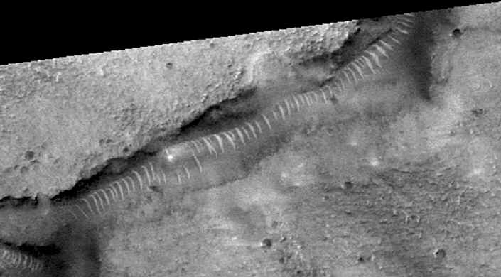
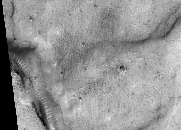
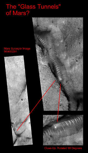
A most interesting feature came to light on Mars recently. Amid the over 60,000 newly-released images from the current unmanned NASA probe (MGS), non-NASA "Enterprise Mission" researchers discovered a strange "tubular structure" in the Martian deserts (MOC frame M04-00291), located at about 40 degrees north latitude. This remarkable "tube," roughly a mile in length and hundreds of feet wide, appears to cling to a desert canyon wall near the canyon's bottom, and extend along its entire length. The feature has the appearance of being "translucent," of being supported at somewhat regular intervals by "ribs," and of being quite cylindrical -- with a localized, internal structure at one point of considerably higher albedo (brightness). To define this feature in purely geological terms has been a considerable challenge. The reasons for this are discussed below.
For starters, the "tube" appears to be very resistant to erosion, as it lies directly along the flow line of what could be considered a fairly major tributary drainage from the surrounding level plain. But, what if it's not "drainage" at all? If not that (which would eliminate one erosion problem for the "tube" - i.e. flowing water), what could be an alternative explanation for this incised feature (the canyon) in this currently totally desiccated desert landscape? A few other geologic mechanisms come to mind: 1) the canyon could be a structural feature, related to faulting and consequent weakening of materials along the trend of the fault; 2) it could be the coming together of two different material types - what geologists routinely term a "nonconformity"; 3) or, it could be the juxtaposition of similar material types, with differing structural orientations on opposite sides of their contact.
None of these potential explanations to explain the "canyon," or the "tube" within it, is totally satisfactory. If faulting were the mechanism, then (with one exception) it could be expected that the feature would be somewhat more linear. (The exception is the trace of a low-angle thrust fault, which can produce a very sinuous path across the landscape.) There doesn't appear to be any major, discernible difference in material types on either side of the "canyon," which would be evidence for a nonconformity. Similarly, there is no clear indication that materials on either side of the "canyon" have different structural characteristics -- such as "horizontal deposits being deposited on and along deposits that have been previously folded or tipped."
What about the possibility of "lava tubes?"
Initially, that seems to be a perfectly reasonable means for creating a "tubular feature" of the size being seen in these images from Mars, and we know (from this and previous unmanned missions) that there has been extensive ancient volcanic activity on the planet, particularly in these Northern level plains. As I see it, however, the "lava tube possibility" becomes much less convincing when one considers two very clear pieces of evidence in the image containing the "tube" itself … and for which there is no reasonable geological explanation as yet.

First: why is it that the tube has "ribs" at nearly consistent intervals, ninety degrees to the axis of the ~600-foot-wide "cylinder," and stretching throughout its entire sinuous path; and, why do the ribs appear to be composed of different materials than the tube itself? Second, if the canyon were there first, the lava would logically flow down its length -- filling it from wall to wall. So, the tube (as a separate cylindrical volume) had to predate the formation of the canyon proper - and had to have formed (or be placed there - see below) under preexisting, overlying materials. If those overlying deposits were volcanic or of relatively homogeneous composition, then what accounts for the (later, eroded) canyon "just happening" to follow the path of the tube proper? From a geologic perspective, understanding the relationship of "the canyon to the tube" is perhaps even more important to solving this mystery than understanding the genesis of the tube itself.
So, what is the genesis of that "convenient" canyon?
Having briefly pointed out --and reluctantly discarded -- what might be considered the most readily recognizable and reasonable geologic mechanisms for these two associated structures, where might a geologist turn next? For, I am a geologist, not a biologist -- but since geology, as yet, gives us no clear-cut answer to this problem, let's at least consider the possibility of an ancient, biologic mechanism to account for this remarkable Martian feature...
Although the following postulation is at first glance preposterous, let's see if there may be some merit in at least its tentative consideration...
If there were a large biological entity on Mars -- such as an annelid-type worm, known for its burrowing and tilling of soils -- such a creature might account for the combination of geologic anomalies, and their association with what appears to be the remains of a large "glass-like worm!" It is a fact that in the image the feature looks like a "glass worm" -- especially if one does not take the prodigious scale into account.
Consider this: our hypothetical alien "creature" is busily burrowing along under the ancient Martian surface, and suddenly there is some sort of "catastrophe" that stops him in his tracks. A considerable amount of time goes by … and the unconsolidated material loosened by his burrowing is simply more susceptible to mass wasting, weathering and wind erosion than the undisturbed materials farther from his path. So, an eroded "canyon" eventually develops in his immediate vicinity, revealing his former presence through removal of the overlying and surrounding sediments …
There is precedent for such "silica producing organisms" here on Earth -- for example, radiolaria -- which produce siliceous "tests." Then, there are other silica-producing organisms that create literal tubular "glass straws" as by- products of their eating habits. (It's the "glass straw" left under the skin of a host by a "chigger" that creates the maddening itch -- long after the chigger has departed).
The unfortunate reality of this "chigger analogy" is also a fairly convincing argument against the reality of our hypothetical Martian "glass worm"; chiggers live off of blood, sucked from an unwitting host. In other words, you have one biologic entity living off another biologic entity. (That's exactly what the rest of us do on Earth to this day-with every meal.) However, on Mars -- where this "creature" is shown to be nearly a mile long and hundreds of feet across, the eminently practical question arises:
"What the heck did it eat?!"
Unfortunately, that simple question -- along with this feature's tremendous length and width -- goes a long way toward discounting such a fascinating biologic speculation. So, what's left?
I may not be a biologist, but I am a registered, certified geologist, and an engineering geologist at that. There is already a groundswell of evidence for engineered structures on the surface of the planet Mars, from past and current NASA missions. The Cydonia region alone has produced some extremely convincing evidence of past construction, not to mention the many other images returned by MGS that now show what would otherwise be inexplicable, "bewildering geology" - if it were not obviously "sound engineering."
In this case - the case of the "mysterious "glass worm" -- that explanation (sound engineering) seems to me, ironically, to be "the simplest, most rational explanation": we may be looking at the exhumed remains of the nothing more "exotic" than the Lincoln Tunnel.
The only thing: it just "happens" to be constructed on another planet.
ADDENDUM
By Ron Nicks
As is common in the milieu of honest scientific inquiry, I find
myself in a position of expressing a dept of gratitude to a colleague
who obviously disagrees with some, if not all, of my previous interpretations
regarding "the worm-like feature" discussed in the body of my
earlier article: "Opening a Can of Martian Worms ..."
He graciously has pointed out one very obvious geologic mechanism that he believes to be solely responsible for this evocative image, a mechanism that I freely admit I simply failed to address in my original article. So, out of respect for dissenting opinions, and borne of a genuine desire to understand, I offer the following brief further discussion regarding the emphatic assertion he has made -- that the subject MGS image shows little more than "sand dunes along a valley floor": known also in the trade as "a dune train."
Many of the recent MGS images from Mars do indeed show what appear to be "unusual" areas of windblown deposition. Unusual in the sense that, the various dune patterns represented seem to be generally pervasive on the planet Mars; whereas, one can find similar patterns on Earth, they are generally not quite of the same magnitude or scale. This isn't too difficult to understand, given the extent and violence of known "dust storms" that have been tracked by telescope on Mars for well over a century, culminating with insitu observations by spacecraft overhead and on the surface.
Nevertheless, let's look again at the subject MGS image (MO4-00291), and postulate that the bright "ribs," as I called them, are indeed nothing more than "dunes along the floor of a relatively narrow valley." This is for certain a totally reasonable postulation-after all, in my original article, I even passingly considered a biologic mechanism (which to me, is a lot more bizarre than an assessment of mere "sand dunes").
It is true that, in my previous written analysis, I did not address the potential for the "worm feature" representing a simple Martian dune train; it is also true that prior to committing my thoughts to print, I simply dismissed the idea as obviously geologically untenable. That is exactly the sort of "unscientific" approach that is so frustrating in much of the literature today, and I feel a bit embarrassed that I myself fell prey to the same arrogance.
So, let's look a bit more closely and see if perhaps the feature is not a "Dune" worm after all … but rather, a simple Martian dune train.
Consider where this feature is located: near the bottom of (and embedded in the side of) a relatively narrow, precipitous incision (canyon) in the otherwise reasonably level surrounding Martian surface. The canyon also appears to have several "overhangs," locally. Now, ask yourself: "which direction did the wind have to be blowing, to create these dune-like features in this canyon?" Some investigators seem to be focusing on light angles, while totally ignoring the crucial wind direction -- when it's the wind that would create such deposition they are postulating … not "the light." (And while it is true that light angles can sometimes give the illusion of "inverted topography", it's also true that it only takes a minimum of field and photo interpretive experience to recognize this possibility and readily adjust for the phenomenon).
The wind either had to be blowing "up" the canyon (toward the north-roughly toward the top of the image here), or "down" the canyon (toward the south). The "dune" forms themselves (if that's what they are) rule out a wind direction at any significant angle to the canyon axis - which is almost due north/south. If the wind was blowing "upstream," then the dunes would be arched in such a manner as their tips -- or the concave part of the "dunes" -- would be pointing, or facing "upstream." That is obviously not the case: in fact, just the opposite is true.
The wind had to be blowing generally "downstream" (from north to south) to create the shapes displayed in MGS image MO4-00291. Indeed, the shapes are quite consistent with all their concave sides pointing downstream. And that's fine.
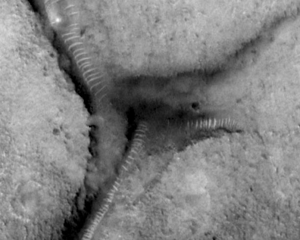
Now, what happens when the wind encounters another entrant into the main canyon -- a '"Y" in the canyon, or the proverbial "fork in the road?" This happens in two places in this canyon system -- one to the north of the bright "highlight" I have ascribed to some kind of object trapped inside the "tube," and one to the south (below).

Well, on encountering such a land surface configuration, one might expect considerable disruption of the previously coherent wind patterns. One might even expect to see considerable disruption in the dune chain itself, with a sudden shift to "chaotic" deposition -- as the eddy currents and wildly varying wind velocities at the intersection result in a truly random (as opposed to previously highly ordered) dumping of the airborne sediment load.
One might even expect that, as the wind blew over the precipice at the mouth of the entrant canyon (the 'Y'), heading south (remember) -- a "plucking effect" would tend to pick up additional sediments and then dump them unceremoniously "in a heap" at the toe of the intruding precipice! There is indeed some evidence of this, but from this image alone it is difficult to precisely determine it's extent -- because the mouth of the entrant canyon (coming in from the upper right - northeast), although partly shadowed, appears to be a very steep slope … if not an actual vertical precipice.

However, if what can be seen at the mouth of that entrant is indeed chaotic dumping of sediments, then (because they are significantly dark) they must be of different composition than the "dune-deposited sediments" of high reflectance - which, remember, is being postulated as a more mundane explanation for the mile-plus long repetitive pattern … in direct opposition to the structural "tube ribbing model" we have favored.
This seemingly insignificant observation -- a dark deposit at this crucial juncture of the "main" and "entrant" canyon -- flies directly in the face of the "opposition's" model: that the airborne materials making up the "dunes" in the main canyon all derive from some other area -- which visibly contains sorted sediments of significantly higher reflectance than the possible deposits at the base of this overhanging northern cliff.
So in reality, what do we see?
Especially at the southern "fork," we see a striking continuation of the "regular dune pattern" (on the other side of the main valley) southwest, right on past this crucial intersection. Furthermore, you can discern the same pattern spacing (the one extending up this second entrant canyon and ending at the canyon wall) at the toe of the precipice (albeit in shadow) -- with only a slight variation from the regularity of the established "depositional" pattern seen in the main valley. How is that possible?
I've run out of aerodynamic answers at this point.
Not only does the continuing regularity of the striking pattern at the "worm forks" pose a serious, non-trivial problem for the "dune advocates," so does the fact that if our assumption of the wind direction -- "downstream" -- is correct (and that is the only wind direction that makes any sense, given the curving geometry of the subject features themselves -- if they are dunes), then we are also beginning to get into serious trouble with that part of their model as well; because, in the entrant canyons (remember, entering from the upper right), the "ribs" or "dunes" are, in areas, approaching an orientation of nearly ninety degrees to those same features in the main canyon.
So, we now have this same wind, simultaneously blowing at almost right angles to itself - while blithely continuing to deposit the same, highly predictable "dune" pattern in two radically different directions!
I don't think so.
In closing, you might think hard about what you are being asked to accept from JPL and NASA as an "explanation" for this totally fascinating feature -- if you take for granted that these regular, curving "rib-like features" are in fact just simple "Martian sand dunes."
You are being asked to "understand" that what you think you see is an "illusion," and that there is a wind on Mars (as opposed to all our experience on Earth) that picks up a small amount of material (in comparison to the size of the canyon itself) from an area of sediments with visibly higher reflectance than that at the canyon site, and transports that material alone-no mixing with any other stuff -- to the subject canyon, and then proceeds to deposit its unique sediment-load down the entire canyon length, and then down the tributaries (that are high-angle entrants to that canyon) … without so much as a significant "hiccup."
If you're willing to believe that, it should not be too great an additional "leap of faith" (for that is what this is) to believe that this same "magic Martian wind" actually has deposited these dunes locally in such a fashion that they appear to be crossing one another, yet each retaining its separate, integral shape (look carefully in the area of the bright "highlight" and "bulge").
Now do you understand why I never seriously considered "sand dunes" as any kind of scientific explanation for this remarkable tube-like feature - with its equally remarkable "supporting rings?"
One mystery still remains: do these investigators, with far more impressive academic credentials, actually believe in their "magic Martian winds?"
