Water, Water Everywhere … but NOT Where NASA Thinks!
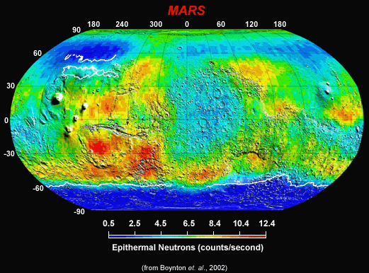
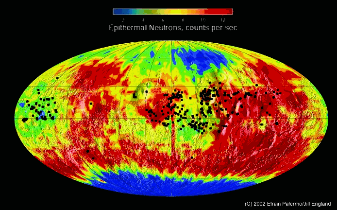
Recent NASA "leaks" (how can it be a "leak" if it comes from inside NASA?) regarding the astonishing amounts of Martian water that have been detected underground in the form of wide-spread reservoirs of ice, have ignited interest in the Red Planet not seen since the days of the unmanned Viking missions. The latest discovery, made by Dr. William Boynton, Principle Investigator of the Gamma Ray Spectrometer (GRS) instrument aboard NASA’s 2001 Mars Odyssey spacecraft, is of copious amounts of hydrogen on Mars (map, above) -- in all likelihood present in the form of frozen water. This has prompted more speculation regarding Mars within the mainstream press than we have seen in years. So much, in fact, that according to NASA "insiders," this "wild press speculation" was the central reasoning behind the abrupt cancellation of the previously planned May 30th formal NASA briefing on the new Odyssey discoveries. One veteran space journalist even termed this "uncontrolled expression" of renewed interest in the Red Planet "the darkest day he’d ever seen in journalism …."
Regardless of that reporter’s curious personal opinion, the discovery of a Mars "literally awash" in frozen oceans (if they all re-melted) has raised the stakes for ALL concerns re Mars – from the ever-present question, "Is there, or was there ever, life on Mars – including actual intelligence!?", to the more pragmatic: "When will we send men and woman in a human expedition to the planet Mars?" Even "Pravda-On-Line" – electronic heir to the well-known newspaper of the old Soviet era, whose very title ironically means "Truth" – could not help gently chiding NASA on its startling “leaks” regarding its discovery of water … if not how it was “coyly” playing it in the press. This is particularly intriguing, considering that the Russians are major members of Boynton’s Team -- having constructed the companion high energy neutron detector (HEND) on the GRS.
Said Pravda:
"The giant ice cluster is another confirmation of hypothesis that Earth-like life existed (or even exists now) on the planet. This information caused an increase in the talk [this week] about the possibility of sending manned exploration expeditions to Mars in the future. Some specialists suppose that NASA plans to perform an expedition of this kind within the nearest 20 years. In fact, regarding today’s level of modern technology, the operation could be performed even sooner. Director General of Russia’s Aerospace Agency Yury Koptev says that it is possible to organize a mission to Mars within the next two or three years [emphasis added]…."
How’s THAT for "boldly going where someone has gone before …?"
Even though NASA's aborted May 30th press conference has managed to throw a little cold water on the increasingly hot topic of Martian ice deposits, nothing can truly stop the inexorable curve we now find ourselves on. As militant factions of the space agency, led by notables such as Gil Levin of Spherix Corp. (a frequent critic of NASA's political suppression of the Labeled Release Experiment, which found highly controversial evidence -- since substantiated -- of current microbial life during the 1976 Viking missions) have now begun to chip away at the brittle casing stones of NASA's monolithic view of the planet's past and present, so too has this new data dealt a near death blow to the notion of “a cold, long-dead Mars.” When we combine all of the observations and data over the years -- from Viking, Pathfinder, Mars Global Surveyor and now Mars Odyssey -- a newly emergent model of a living, breathing (if perhaps lightly slumbering) Mars has taken hold, and it is unlikely that all the Kings Men can ever put this particular genie “back in the freezer.”
But if, as our critics always say, NASA is truly an "open and honest civilian science agency," why would they not want to take advantage of the biggest sea-state change in the world's view of not only our solar system … but our own place in it as well? Why would they seek to downplay the biggest cash-cow news story the Agency has had since John F. Kennedy called upon them to beat the Russians to the Moon?! Why would they seek to suppress that which they claim to have been looking for all throughout this recent surge of unmanned Mars exploration? Whatever happened to their "follow the water" mantra? Are they only willing to follow it … if it fits with their pre-conceived (and obviously now erroneous) notions of what Mars is and was?
Or, is it that they have now found precisely what they were looking for all along -- and need to make sure the rest of us don't catch on too soon to the real game being played?
Clearly, flatly, NASA’s “duck and cover” behavior on May 30th makes no sense at all … except in a political context. Just as we have argued that the Cydonia debate has long since passed the Rubicon of a scientific question into the realm of blatant politics, so too does this notion of water in abundance on Mars – with NASA running from even formally addressing its amazing implications -- now has fallen into that same category. The striking evidence of water in great quantities on Mars, not just at the poles but also distributed in the equatorial regions -- just as we predicted in our Mars Tidal Model almost a year ago -- not only now answers many long fought debates about the planet, it also raises many more uncomfortable questions NASA obviously wishes to not even address, let alone answer, at this moment ….
Serious “anomalists” should certainly be asking: “why!?”
We, of course, we were not surprised by these developments -- either by the latest NASA Odyssey discoveries, nor by their treatment in the international media. We not only specifically predicted Odyssey would find such significant amounts of "fossil water", we also predicted that the mainstream press (prompted by the "roosters") would use this as its next carefully timed "cue" to publicly ramp up serious discussion of a manned Mars Mission. We even went as far as to specifically predict last year where Odyssey would find important concentrations of this water … in addition to the polar regions, in two equatorial locations, spaced 180 degrees around the planet … which Dr. Boynton and his GRS team have now so graciously confirmed (see map).
There is only one small problem with this elegant depiction -- NASA’s official description of its own Mars data (below).
"Observations by NASA's 2001 Mars Odyssey spacecraft show a global view of Mars in intermediate-energy, or epithermal, neutrons. Soil enriched by hydrogen is indicated by the deep blue colors on the map, which show a low intensity of epithermal neutrons. Progressively smaller amounts of hydrogen are shown in the colors light blue, green, yellow and red. The deep blue areas in the polar regions are believed to contain up to 50 percent water ice in the upper one meter (three feet) of the soil. Hydrogen in the far north is hidden at this time beneath a layer of carbon dioxide frost (dry ice). Light blue regions near the equator contain slightly enhanced near-surface hydrogen, which is most likely chemically or physically bound because water ice is not stable near the equator ..."
Some background:
It is critical to be clear on what NASA’s actually found: Odyssey has not directly detected any Martian water. What NASA has detected is hydrogen on Mars – LOTS of it (through neutron absorption) … which is assumed (for good scientific reasons -- see below) to then be bound in the familiar water molecule.
The existence of a frozen “planetary ocean” on Mars, at this point, is therefore only a logical deduction by Boynton and his Team; the deep blue (again, see map) -- corresponding to the lowest number of "epithermal neutrons," and thus the highest concentration of Mars hydrogen -- is the direct measurement. The "leap" to water (ice) is based on simple chemistry … and the projected "universal abundances" of elements in the primordial solar system. Mars, in this extended logic chain, is presumed to have formed (like the other planets) from the water-rich materials of this primordial solar nebula. Thus, the massive amount of hydrogen now observed on Mars is presumed to be contained in some cosmically abundant compound, and in similar amounts, to that observed in the current Sun and in recovered meteorites … water. Hydrogen alone would have long escaped from Mars, and there just isn’t any other abundant hydrogen compound which would be found on Mars under past or present temperature conditions … and certainly not in these observed amounts. So it is this step-by-step process of “cosmic elimination’ of all other possibilities that forms the basis of the staggering new NASA claim that the "degree of blue" on Boynton’s map represents a concentration of vast fields of water ice beneath the Martian soil -- and not something slightly more exotic … like Champaign!
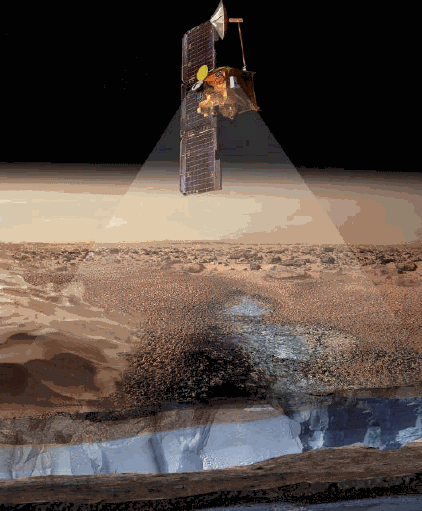
However, since Odyssey’s GRS cannot detect neutrons coming up from Mars much below three feet (graphic, below), the presumed concentration of ice currently reported in the soil near the poles (50% to 60% by volume), is only a lower limit to such ice. If the Martian "permafrost" extends significantly deeper (some investigators have speculated it may go down well over a mile …), the amount of water still undetected by Odyssey could truly be enormous. Already, NASA’s published estimates project that the water Odyssey is currently inferring – if completely melted and spread around the planet – would cover the surface of Mars to a depth of over 1500 feet!
But a curious thing happens in NASA’s scenario, when they move from interpreting the dark blue (high hydrogen/water concentrations) draped around both poles, to the areas of lighter blue. As we said before, this hydrogen is suspiciously concentrated in two regions along the Mars equator … 180 degrees apart -- the Tharsis Bulge and Arabia Terra.
Suspiciously consistent with our Mars Tidal Model.
In the simplest interpretation, this lighter blue obviously corresponds to less subsurface hydrogen … i.e. less water. The actual amount is color-coded from Boynton’s published calibration, so the amount of hydrogen (water) can be read pretty much directly from the map: in these equatorial regions it is approximately half that proposed around the poles.
That’s still a LOT of water … about 15 to 20 % of the Martian surface soil -- and remember, only measurable in about the top three feet ….
At this point in the logic, there’s a major NASA hiccup.
The Agency -- suddenly switching from its own interpretation -- insists in the official caption accompanying the map of water distribution (above), that the lighter blue areas at the equator (remember – strikingly confirmatory of our Tidal Model), unlike the deeper blue around the poles, is NOT indicative of water … but "free hydrogen," bound “somehow” (they don't even attempt to speculate) to the surface soil itself. Quoting:
" … Light blue regions near the equator contain slightly enhanced [slightly?!] near-surface hydrogen, which is most likely chemically or physically bound because water ice is not stable near the equator [emphasis added]."
This is a crucial point … easily the most important (if overlooked in the excitement) of NASA’s entire new "water Mars" extravaganza .. ..
For, it should be obvious from this official NASA statement -- the outright denial of water right where we’ve specifically proposed it, at the equator, in two regions 180 degrees apart -- that there is a severe contradiction between what NASA is now willing to admit about the history of Mars and "water"… and what we’ve figured out.
So, how do we clear up these significant discrepancies? Does the new Odyssey data truly validate our Tidal Model ... or does it support NASA’s standard story after all?
To answer these important questions, it is obvious that we must unravel several hidden assumptions built into NASA’s latest water model.
· First, the assumption that the current quantities of ice detected by Mars Odyssey HAVE to be "primordial," i.e. present in their current locations on Mars from literally billions of years ago -- the only time Mars (in NASA’s scenario) had a far more temperate environment.
· Second, the assumption that this early Mars then slowly froze -- across up to half a billion years -- leaving the then icy planetary ocean exposed to solar radiation … to slowly evaporate over millions of years, with any water originally located near the equator migrating toward the poles … to permanently refreeze.
It is this last assumption that is the major basis for NASA’s official claim that the hydrogen detected by Odyssey … on the Martian equator … cannot currently be ice or liquid water. The reasoning is simple: if Mars truly "died" billions of years ago (as NASA publicly espouses), during its so-called "Naochian Period," any ice then on the equator would have by now completely sublimated from the lower latitudes and moved to the coldest places on the planet – the poles. This, in NASA’s interpretation, is why we see the darkest blue (most ice) now only at the highest latitudes; in their model, this simply represents the slow but inexorable migration of all the evaporated/refrozen water to the coldest regions. Therefore, the hydrogen currently observed by Odyssey on the equator -- in this official view -- has to be some kind of "chemical signature" of former equatorial reservoirs of ancient water (perhaps some kind of hydroxyl radical -- like HO, not H2O) … but certainly not current quantities of water (or even ice).
What is unexplained in this view is “why” these former “ancient water reservoirs” turn out to be located only in two locations -- counter intuitively coincident with the tops of the major geological “bulges” on the planet (why would the ancient water lie on the top of such bulges, and not in the “valleys” in between?) … and spaced 180 degrees apart --
Precisely as the Tidal Model mandates.
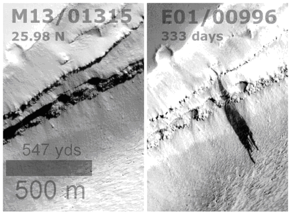
Also unexplained in NASA’s current thinking is the nagging presence of those mysterious, dark "stains" -- which we discovered "leaking" all across Mars in 2000, long before Odyssey’s latest revelations (below).
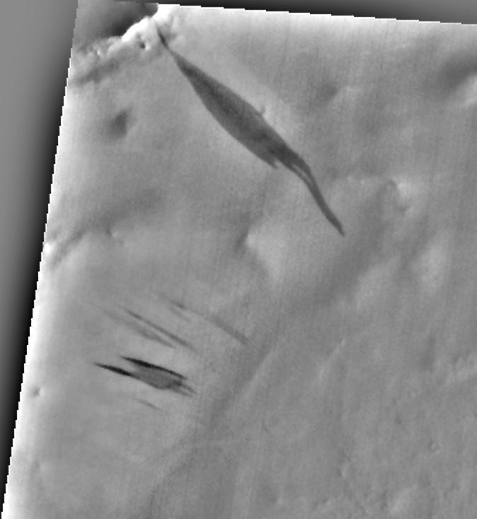
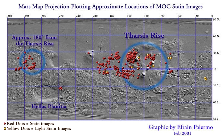
Following our lead, Palermo and England subsequently plotted the first comprehensive global distribution of these tell-tale water features … now termed "seeps" … and discovered that they are also centered on the equator -- and distributed in two, suspiciously 180-degree locations precisely coincident with the most massive Martian "rises" or "uplift bulges" on the planet (see below).
These “seep” parameters have all the earmarks of a current liquid … even now, upwelling from underneath the dusty Martian surface in regions of gravitationally determined, former tidal forces. Similar to NASA, we therefore concluded that such a “leaking” liquid could only be real water – because of its universal abundance, and Mars’ current temperature regime. But unlike NASA, we believed that this water was liquid now … and obviously still leaking out of the ground precisely where these two former tidal oceans once existed. In fact, time lapse Mars Global Surveyor photography (below) easily demonstrated “before and after” images of such “eruptions” – MOC views showing seeps newly spreading from locations dry just months before ….
How then to resolve this obvious, major contradiction with NASA’s current views -- which have consistently dismissed these strange flow features as mere “dust avalanches.” Just as they now dismiss Odyssey’s equatorial detection of hydrogen – precisely in these same “seep” regions -- as “just chemistry” For, when overlaid on the preliminary GRS maps of Martian water distribution from NASA’s March press briefing (below), the correspondence of the “seeps” -- remember, evidence of current liquid water in our model -- and the Odyssey regions of enhanced hydrogen on the equator -- is striking.
What’s going on?!
It’s simple. The water Mars Odyssey has now detected on the Red Planet is NOT "old," as NASA continues to emphatically insist, but --
Young!
In the Tidal Model, the oceans of Mars were extant up until approximately 65 million years before the present -- just “yesterday” in Martian history. Because this is when the catastrophe occurred, this is when the oceans finally froze … not 3.5 billion years ago. Thus, instead of 3.5 billion years of evaporation and refreezing at the Martian poles, the waters from the two equatorial oceans “only” have had ~65 million years to sublimate out of their equatorial sediments and soils … This is why Odysseys mysterious equatorial concentrations of hydrogen, and the locations of the seeps, so neatly correspond because the frozen sediments beneath these regions from the two former tidal oceans --
Are still melting!
As you can see from the overlaying of Palermo and England's seeps maps with the Odyssey Epithermal Neutron distribution, the seeps correspond almost precisely with the equatorial water hydrogen distribution now downplayed by NASA. The correlation is inescapable.
To pretend that a phenomenon that has all the characteristics of liquid water flows, corresponding so exactly to areas which Odyssey has now confirmed contain vast amounts of hydrogen, and to continue to insist they are not indications of existing water/ice, but rather “some sort of exotic [but unspecified] hydrogen bonding agent,” is an unnecessarily complex ad-hoc explanation … obviously devised to avoid the obvious -- that the Tidal Model is correct! For our critics, who are constantly trying to cite the notion of "Occam's Razor" in response to our data on Cydonia (fallaciously, since the competing notions of “artificiality” vs. “natural genesis” are hardly equal -- in terms of their inherent geometric complexity), we ask only that they now apply the same “Occam’s Razor” here.
Which model is more likely the correct one now -- the model which has no good explanation for water ice in any major quantity, on a supposedly “dead and desiccated planet,” or the one which specifically predicts both the volume and location of that water … and with exquisite precision?
Because these Odyssey results are so consistent with our Tidal Model, it is far simpler to now concede the obvious -- that Odyssey has found so much water, and in locations positively prohibited by the competing model, that it is increasingly obvious that Mars had to have had liquid water and its accompanying temperate climate much more recently than the Naochian Epoch. Occam will not permit any other conclusion from the data. In fact, Mars was almost certainly “living and breathing” as recently as 65 million years ago -- when an unspeakable cataclysm abruptly caused tremendous disruption to its ecosphere … and, simultaneously, almost every other body in the solar system.
The reason this is now a highly likely scenario, is that so much water still remains (according to Odyssey’s observations) in the equatorial latitudes (concentrated in Tharsis and Arabia). It simply has not yet had time (compared to the competing model) to significantly sublimate and migrate to the poles!
This model is even strongly supported by the Odyssey observations that the peaks of Tharsis (over 16 miles up) are almost bereft of hydrogen (in the upper three feet, anyway) -- yet still have great numbers of seeps showing in the MGS images taken of the area. Obviously, the water sublimation process is going to be more far rapid and dramatic at higher altitudes, where the atmospheric density is low and thus even modest daytime temperatures can drive more water from the soils. Yet, even in this high altitude region, there is apparently still enough water below the GRS detection limit to account for continuing, abundant “seepages” in the MGS images that have been taken, virtually guarantying that -- even at this amazing altitude -- our theorized former "tidal Tharsis Ocean" is the ultimate source.
And there is more. When you consider this new Odyssey data for these two regions, together with all the relevant supporting data from our Tidal Paper -- the seeps; visible flow erosion signatures all across these regions, identified by MGS; other, massive catastrophic flow channels identified by University of Arizona researchers on other MGS photography; and the subsurface, literally buried massive outflow channels discovered in the MOLA data -- it quickly becomes obvious that the newly discovered hydrogen deposits in these same regions simply have to be the remnants of the two former tidal oceans predicted by our Model.
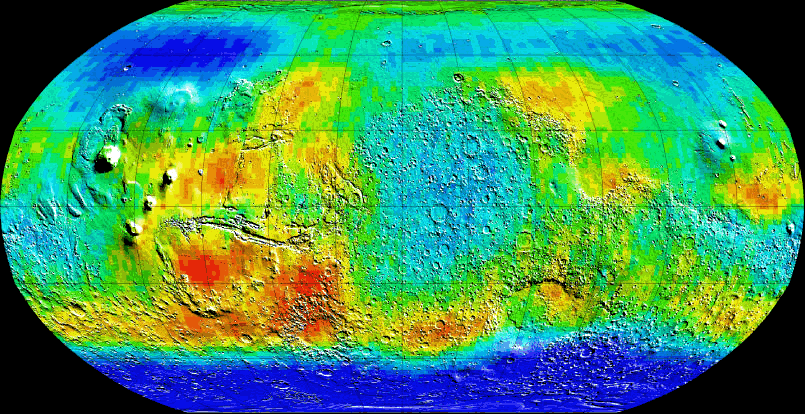
Looking elsewhere on Mars, as you can see from the above animation the source of most of the northern hemisphere NASA-acknowledged water (deep blue) is unquestionably also our former, twin bi-modal tidal oceans. When the tidal lock with Planet V was severed, the water took the path of least resistance and flowed out from Tharsis and Arabia, carving massive flow channels identified by MOLA (teal) and MGS (white arrows). These raging outflows ran "downhill," down from Tharsis through the ancient and pre-existing Valles Marineris, and off the Arabia rise through the Oxia and Luna Pallus regions (causing massive, literally miles of vertical erosion in the process). These incomparable streams eventually joined up right around Kasei Valles, and then flowed together into the Arcadia region, where the densest concentration of northern hemisphere near-surface hydrogen has now been mapped. Another massive flow (50,000 times the flow rate of the Amazon river and 10 times the size of Kasei Valles) ran northwest of Arsia Mons and around Olympus Mons, ending up in the same massive northern reservoir of water -- all of these raging, rushing floods converging to form a literal “new northern Martian ocean.”
The seeps overlaid on the above image confirm where the highest concentrations of liquid water still exist today -- in the equatorial (though high-altitude) beds of these two former tidal oceans.
Remarkably, if somewhat belatedly, at the recent Spring 2002 Meeting of the American Geophysical Union (AGU), three very mainstream planetary scientists -- O. Aharonson, S. Khatiwala, and N. Schorghofer -- presented, from a completely independent analysis, a similar possibility of current liquid water on the surface of the planet.
“The Mars Orbiter Camera on the Mars Global Surveyor spacecraft has returned images of numerous dark streaks that are the result of down-slope mass movement occurring under present-day Martian climatic conditions. We systematically analyzed over 23,000 high-resolution images and demonstrate that in addition to forming exclusively in regions of low thermal inertia and steep slopes, streaks form only where daily peak surface temperatures derived from TES data exceed 275 K. The northernmost streaks, which form in the coldest environment, form preferentially on warmer south-facing slopes. Repeat images of sites with slope streaks show changes only if surface temperatures exceeded the melting point of water during the time interval between the two images. These correlations suggest the possibility that small amounts of water are transient and undergo phase transitions at times of high insolation, providing a trigger for the formation of the features.”
Gratifyingly, the authors even remembered England and Palermo’s global seeps distribution paper, published last year, and included it as a reference in their 2002 AGU presentation. Unfortunately, they apparently were unaware of our even earlier proposal to Palermo and England, on March 11, 2001 – that Palermo and England plot the seasonal distribution of the seeps, with an eye toward flows appearing when the Martian ground temperatures were above the freezing point of water.
From Hoagland’s e-mail exchange that week:
Efrain,
How are you coming with the Map, and its derivative -- the SEASONAL map? If these "present" flows are on MGS images taken only during the Summer, then we've REALLY got something.
Still working on the bi-polar "longitude" anomaly .... Very interesting.
RCH
England subsequently attempted such a statistical analysis -- plotting seeps against the Martian seasons. But, working part time, and only having the computer facilities to analyze a couple hundred images -- as opposed to the literally thousands in the present NASA-funded study -- her results were disappointingly inconclusive.
On March 18, 2001, however, England did discover a series of overlapping MOC images of the same regions containing “before” and “after” evidence conclusively proving that the seeps are a currently occurring Martian phenomenon. “Seeps” weren’t just old, dark stains indicative of some kind of ancient water flow -- Mars was still “leaking!”
All three of us are therefore very gratified that Aharonson, Khatiwala, and Schorghofer finally found what we were searching for … compelling statistical evidence supporting the current liquid water model. Their work, of course, also now strongly supports our previous assertion: that the hydrogen Odyssey’s discovered at those two key equatorial positions, is not some kind of “funny chemistry”… but real ground water.
Others, for different reasons, agree with these seminal conclusions. Dr. Gilbert Levin of Spherix Corp., has staged a two decade long political battle with NASA regarding the positive results of his Labeled Release Experiment on the Viking Landers (See "Sir Arthur Up's the Ante" - 2001). He has repeatedly argued that experimental results from Viking, Pathfinder and now Odyssey support the conclusion that water can exist in a liquid state not just in the ground beneath, but actually on the surface of the current Mars. His calculations show that there is sufficient atmospheric pressure to provide for water in this state, and he has argued that images from Viking appear to show simple plant forms, like lichens -- growing and receding on rocks within view of the Lander cameras -- with the Martian seasons.
The only “chilling” element in this equation -- up until now -- has been the NASA view that Mars was simply “too cold to support liquid water.” The carefully crafted political notion that Mars was a frozen, uninhabitable hell is called into serious question by images such as those Levin has cited, and also other, orbital examples – images that show current water spouts on Mars. Add in the seeps evidence and Odyssey‘s latest results, and it is quiet clear that water is indeed present in some form everywhere on Mars – and certainly as a current liquid in the equatorial latitudes of the Red Planet.
The final proof of this has come, ironically, not from Odyssey, but from the venerable old Mars Global Surveyor. Surveyor has carried an instrument which up until now has been pretty much an afterthought, called the Thermal Emission Spectrometer (TES). One of the most stunning (and stunningly ignored) results from this instrument has been its finding that during the summer on Mars (remember, Mars' year is about twice that of Earth's), the regions of Mars even above 40° lat. warm to a ground temperature of over 60° F! Obviously, this is well above the threshold at which water can exist in a liquid state, and resoundingly destroys the last objection to the seeps as liquid water.
So, what we have here is an increasingly open and shut case -- not just for the reality of liquid water on the current Mars, and the suddenly, vastly increased probability of some form of “life” because of it ("Arthur's Bushes" anyone?)-- but for a dramatic rethinking of Mars' entire past …. a past that now has enough time and the resources to potentially evolve indigenous intelligence--
Which has left us haunting clues to its existence … the remnants of which we have been pointing out for more than 20 years.
But Mars’ previous incarnation as a tidal satellite, of a now-destroyed, larger parent world, has even far greater implications ….
Whatever cataclysm nearly sterilized the Red Planet, also cleared the way across millions of miles of space and several million years for the emergence of our own species … here. The cautionary tale is this: whatever overtook "Planet V" and blasted Mars with such a scorching vengeance, could also happen here. Until we fully understand what it was that caused the destruction of the Sun’s Fifth Planet, we cannot rest … foolishly believing that Earth is somehow immune. And the only way we will ever know how great the danger is, is if we fully explore Mars with a truly open mind -- beholden not to our outdated preconceptions of Mars’ history, but rather to its own inevitable Truths … and soon.
On this last point.
We have yet another coming opportunity to separate our own revolutionary Tidal Model from the conventional (and now almost totally discredited) Mars history put forth by NASA since the days of Mariner. If we are correct, there will be yet another tell-tale sign of our ancient Martian oceans found by Odyssey in the near future. Just a few days ago, the Mars Odyssey team extended the boom that holds the spacecraft's Gamma Ray Spectrometer. This will allow a much more accurate reading of the chemical composition of the Martian surface, and should reveal at least one additional clue that forever seals the Tidal Model as “the only game in town.”
Chlorine.
As Enterprise principal investigator Richard C. Hoagland first pointed out in Monuments, over 15 years ago (page 179)--
| … the surprising abundance of chlorine in the Chryse samples, not explained by the Viking team, seems evidence to me that Viking was sampling stuff which had formerly been on the bottom of a salty (!) ocean. The presence of so-called “duracrust” around the spacecraft, as a chemical “cementing process” from salts seeping upward from below, is also consistent with this concept. Shades of the immortal Edgar Rice Burroughs’ “dead sea bottoms of Barsoom ….” |
If Mars once had oceans, certainly for anything approaching half a billion years … those oceans had to have left behind specific signatures of the chemistry of “oceans “…. Former massive oceans of salt water, bi-modally locked on the Tharsis and Arabia uplifts, will have left inevitable traces of sodium chloride in the soil. Odyssey’s GRS will certainly be able to verify the existence of these areas of dried up salt within the next few months, and in the process determine the extent and location of these former ocean beds. Our prediction, based on the Tidal Model, is that major concentrations of these ocean salts will be found on Tharsis and Arabia ... precisely where Odyssey has found its excess equatorial hydrogen. Lesser amounts will be found in a trail of channels leading down to the “northern ocean,” -- as the chlorine, sodium and other dissolved compounds dried in place after the catastrophe, and the release of the two former tidal seas.
Confirmation of this predicted “ocean chemistry” should finally, ultimately put to rest all further questions regarding whether Odyssey’s equatorial hydrogen is actually contained in water. At that point NASA will have an interesting problem: admit the obvious … that the Tidal Model is correct … or continue to pretend that we’re “all wet.”
Stay tuned ….
Update: 6/19/02 - In this space.com article by staff writer "> Leonard David, Dr. William Boynton, Principle Investigator of the Gamma Ray Spectrometer (GRS) instrument has now admitted that low latitude (i.e. equatorial) water ice is "possible." This shift in opinion is an indication that NASA's stance on the hydrogen discovered on the Tharsis and Arabia bulges may be softening. Now, if they'd just notice it is bi-modally distributed ...