It's Only a "Whole New Mars" -- To Them ...
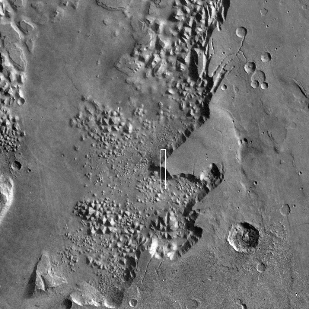
Mars Odyssey Infrared Image of The Hydroates Chaos Region of Mars
(Enterprise Mission Enhancement)
You've got to hand it to us. When we're right, we're right.
Just as we told you yesterday, NASA today held a press briefing regarding the first data returned to Earth from Mars Odyssey 2001 spacecraft. As expected, what was presented was, quite frankly, nothing less than Earth shattering (well, Mars shattering at the very least). And, as expected, the NASA scientists presenting the data made absolutely no issue of the incredibly bizarre images and data they presented. They just acted like it was ho-hum stuff.
It was hardly that.
Almost from the beginning, many of the scientists at the briefing seemed a bit nervous and uncertain. Dr. Phillip Christensen, especially, seemed edgy as he presented images from the infrared camera.
Small wonder.

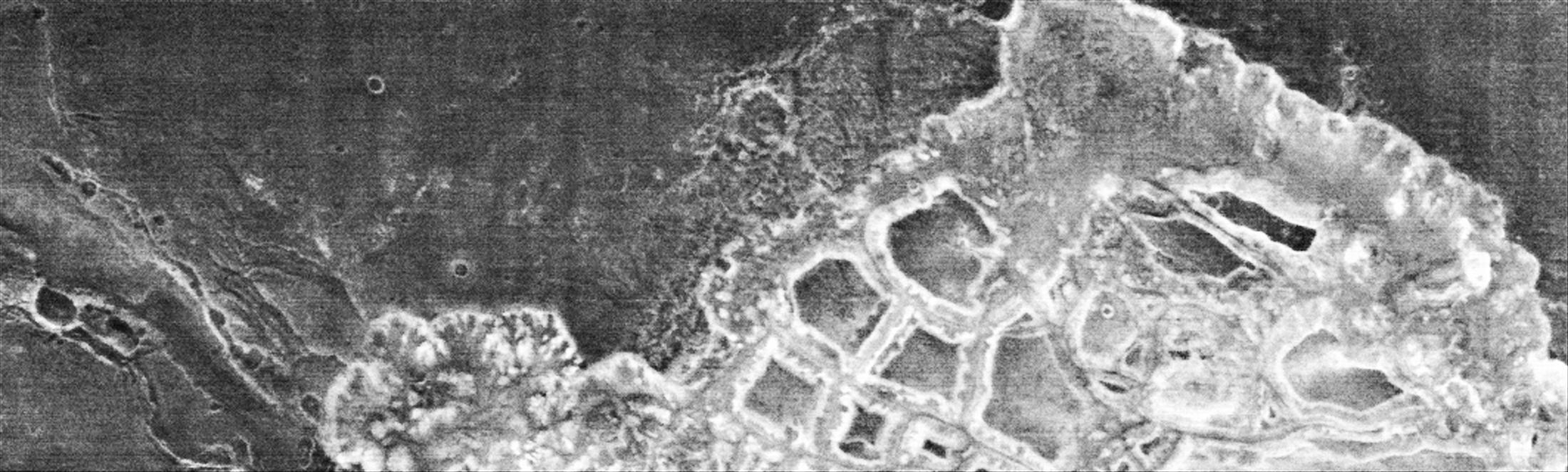
The most significant image presented was of the Hydaspsis Chaos region of Mars. If that sounds familiar, it should, it is just a few miles from the Hydroates Chaos Region of Mars (0.9 north, 34.3 west vs. 2 degrees north, by 29 degrees west), the location of the stunning Phobos 2 image we posted in our story yesterday. So, as we expected, we got an IR image of virtually the same area exactly 13 years to the day from the moment Phobos 2 took its picture.
Cute, huh?
And what a picture. As Christensen haltingly displayed the image to the assembled media, he made no mention of the stunning regularity of the terrain -- especially considering it's dubbed "Chaos"!
Infrared close-up. Bright areas are warmer, darker areas are
colder. North is right in this image.
What's most striking initially is the incredible consistency of the "channels" between the "sand covered mesas" (how does sand stay on top of a flat "mesa" that is buffeted by 300 MPH winds from time to time?) in the image. The channels all seem to be about the same width, and remain incredibly consistent for miles. The mesas themselves are shockingly geometric, not really what one might expect from a fluvial erosion process.
But the Devil of course, is in the details.
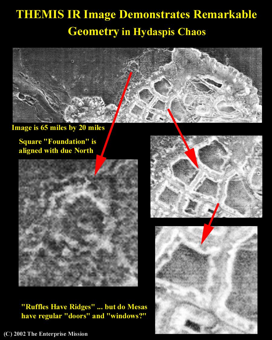
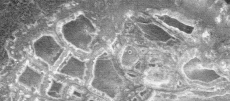
"Quick and dirty" close-up enhancements, done just hours ago, show some very unusual features of these "mesas." There are regular, geometric "notches", or even openings, in some of them, and others show signs of being buried foundations for larger objects.
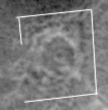
A little further up in the image is a strange looking "crater" plastered on top of a dark rectangle with incredibly square edges. Considering that this is not aligned with the image scan, but is aligned with actual North/South, we're inclined to doubt this is an image artifact or natural formation. We're also reluctant to conclude that the "mesas" are just that, and we'll reserve judgment until we have a chance to look for a visible light image of the same area. Unfortunately, this was not provided at the press briefing, as is customary, so it is tough to find such an image on short notice. However, we're reasonably sure that the Viking image below is of the same area, with the "mesas" in question near the top (the Phobos 2 image area should also be within the boundaries of this image).
The visible light camera on Odyssey should be able to provide color imagery at least 50% better than the best Viking, so hopefully we'll be able to pinpoint the exact location of this IR image eventually.
But as cool as the IR data was, the Gamma Ray Spectrometer data was even more exciting, at least to us. The GRS has a very coarse resolution and isn't fully deployed yet, but the team, led by Dr. William Boynton, gathered some data anyway while the instrument was still in its "parked" position.
Of the data, the most crucial was the information gathered on "High Energy Neutrons". These types of Neutrons are typically absorbed by hydrogen -- a key component of water and water ice -- so by measuring areas with little or no "HEND" return, it is possible to determine just if, and how, water is distributed on Mars.
High Energy Neutron map from today's press briefing. Blue areas indicate presence of very few neutrons of this type, indicating the presence of liquid water or water ice. South Polar cap is in the center. Other blue areas correspond to Tharsis and Arabia bulges, precisely as predicted by Mars Tidal Model.
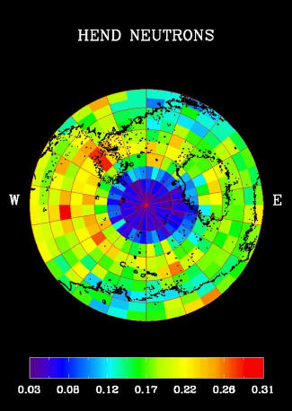
As it turns out, there is a hell of a lot of water, or water ice, on Mars (NASA has argued it is ice, but already Viking scientist Gilbert Levin has declared victory and argued persuasively it is liquid water, not ice) . Most of it is clustered (as expected) in the South Polar cap, but huge amounts of it are also present on two specific (and bi-modally opposed) areas of the planet --
-- the Tharsis and Arabia bulges.

Most of you will recall that these are the two areas where the so-called "water stains" we first reported on back in July 2000 were found in greatest abundance. Thanks to the work of Jill England and Efrain Palermo, who mapped the global distribution of the "stains," we discovered that they clustered preferentially around these two enormous bulges in the Martian crust. This observation led us to conclude that the bulges were in fact artifacts of a former tidal lock relationship between Mars and a parent planet, and that the water stains were the remnants of an ancient ocean, bi-modally distributed and held in place by the tidal forces. We then published these findings in an 46 page paper posted on our site last year.
Because of our specific prediction more than six months ago in our paper, that Odyssey would find exactly this anomalous (beyond our model) water distribution, we can state categorically that these findings constitute absolute, inviolable confirmation that our model is correct. It also proves that the work done by Palermo and England is correct, since the water distribution corresponds precisely where they have found what are now proven water stain images.
What was stunning was that neither Boynton nor any members of the assembled press, either because of ignorance or timidity (is there any American institution that has fallen into a greater state of disrepair than the Fourth Estate?), made the slightest note of the fact that the water -- inexplicably for the established conventional models of Mars evolution -- was distributed on two such prominent features of the Martian landscape. This does not change the fact that there is nothing -- absolutely nothing -- in any conventional model that can account for this distribution. The only explanation that fits the data is our Tidal Model.
Even after they had hyped the data to be presented as a "whole new Mars," and "tremendously exciting," not one of the scientists bothered to explain just why any of this constituted a "whole new Mars" --
--and nobody asked!!!!
This astounding lack of curiosity by the press to as just what made this data so exciting just played right into the NASA strategy we predicted last night. NASA's policy is clearly now one of disclosure -- but unacknowledged disclosure. Only a thorough inquiry by the press can loosen up the lips of these project scientists, but since they seem reluctant or incapable of questioning the Agency, as usual, that task is left to us. But now we can set about the task with both barrels loaded, and our powder dry.
Welcome to our world, NASA.