A Closer Look at a Distant Place
Twin Peaks-Mars Part II
After about five months of reviewing images from the Mars Pathfinder mission, including striking, new, high-resolution images released November 4, 1997, it now seems reasonable to update some of my observations regarding the twin peaks. The following discussions are generally centered around the same topics (shapes of the hills, breaks in slope, orthogonal patterns, etc.) as those presented in the original `A Closer Look at a Distant Place' posted on the `enterprisemission' web site.
Although in an early NASA Pathfinder press conference Dr. Peter Smith a Principal Investigator for the mission, originally postulated a couple of geologic scenarios for creation of the twin peaks. As yet, I am unable to find any follow-up, in-depth discussion of the geology by NASA as promised at that press conference by Dr. Smith. At the time of the press conference, Dr. Smith indicated that among NASA priorities regarding the mission, the geology of the twin peaks was of great interest, and information regarding same was forthcoming. However, the specific scientific measurements and analyses seem to concentrate among other things on such findings as high Silicon content of some of the materials near the lander, which somehow was translated into high quartz content, which in turn was postulated as meaning some of the rocks are `andesite like'. Unusual in my estimation, as andesite is notably lacking in quartz. Regardless, this seems to me as though it's an example of multiple, compounded errors in judgment attempting to fit snippets of information into what may be outdated theses. Albeit trite and overworked the phrase `can't see the forest for the trees' seems to have some application.
With the release of the recent high-resolution images some of the questions raised in my earlier analysis are answered, but some questions remain, and indeed, others arise; especially with regard to `south peak', the one to the left in the image. It now seems as though much of the detail that I discussed with regard to orthogonal structure in `north peak' and the apparent absence or at least muted nature of similar structure in the peak to the south, was simply a function of the south peak being somewhat farther from the camera with the attendant loss of resolution. Now, with the newly released November 4 images, the same striking orthogonal structure can be seen in the south peak as well. South Peak and its attendant orthogonal structures, although apparently subjected to catastrophic degradation, retains a degree of complexity, and organization that is striking.
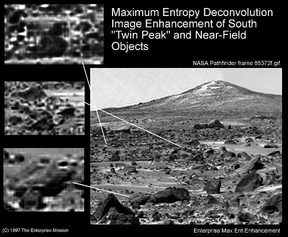
In my initial study I went to some length discussing various breaks in slope along the edges of both peaks. Regarding south peak, the break in slope is especially noticeable along the left edge. The new images clearly show why this is so. There is a clear `stair-step' set of well defined orthogonal features, much like large blocks that can be seen descending the slope. These features are plainly evident below the horizon (essentially beginning at the break in slope), are orthogonal in form, and are oriented in such a way as to make difficult any explanation, of which I am aware, that could ascribe them to computer compression artifacts. The `blocks' are uniform in nature, are not randomly strewn, but rather `stacked' in a regular identifiable pattern.
Orthogonal patterns, and blocky `textures' are readily found in nature. However, in my experience, they tend to be associated with features that, on a larger scale than the individual `blocks', display similar symmetry. In other words, the shape of an overall structure is in a very general way reflective of the shapes of smaller components that make up the overall structure; said differently, you wouldn't typically find in the natural, physical world, square or rectangular blocks being the constituents of largely triangular structures. Triangular (or conic) structures do occur in the physical world, but almost inevitably as a result of erosion or some other outside force that has altered the original shape. If one can accept that, then it is hard to explain why relatively well defined, orthogonal blocks would be evident along the edge of an apparently conical structure. After all, the edges are subjected to the greatest potential for erosion which creates the conical shape in nature. Yet, at south peak we have an edge of a triangular (or at least conical) hill comprised of sharply delineated orthogonal blocks. This remains difficult to explain based solely on geology and geomorphology.
The new images of south peak also show some striking vertical structures that are complex and irregular in their location about the slope, yet not chaotic. What do I mean by that? Perhaps an analogy would help to clarify what I am trying to describe. Consider a picket fence. If some of the pickets were removed in a random way, and some of the pickets were re-nailed at varying elevations making their tops and bottoms uneven, that would leave the fence with a `gapped tooth', up and down, `complex', type of appearance. Yet the fence would still be easily recognizable as a fence, even though its is irregular, but certainly is not chaotic. That is what I am trying to describe with regard to these vertical features on the face of the south peak. They appear to trend up and down the face of the peak as well as across the face. Their height appear to diminish with distance (perhaps just a relic of perspective), and some have what looks like inverted `L' shaped extensions at their tops. They appear to be somewhat `delicate' or spindly--all things considered--and are to me totally anomalous with regard to any geologic or geomorphic process. Regardless, how such features could be generated naturally is not in my experience; perhaps others can explain.
I find that trying to describe the geology or geomorphology of the twin peaks is a less than trivial task. Could it be that the peaks themselves do not lend themselves to geologic descriptions because geology may not provide the appropriate set of tools with which to shape a description? Based on the apparent lack of any in-depth, public, geologic discussion of the peaks by NASA, perhaps they too have reached a similar conclusion. Without some definitive answers to the questions I raise regarding the observed features I have discussed, the serious researcher is left to their own devices without any input from the one agency that could provide the answers; or have I simply not yet looked in the right place?
So that I might not fall into the `not see the forest for the trees' trap by concentrating too closely on one or two features, I have chosen to analyze not only the peaks themselves, but features more readily discernible in the middle and foreground of the high resolution images, as well as in the same area of image 80881. This ongoing analysis continues to raise some questions regarding even more fundamental geologic or geomorphologic considerations.
In previous studies I have mentioned `pointy stuff'--not very scientific but at least descriptive. Not only is the `pointy stuff' anomalous, so are the blocky objects that appear in somewhat localized areas in 80881 and in the high resolution images. This is the reason why the apparent anomaly. If indeed the materials in the foreground and middle ground of the images are a product of transport during massive, catastrophic flooding from the highlands hundreds of miles distant, then how is it that the orthogonal blocks so evident in 80881, and similar orthogonal structures in the high resolution image of the south peak, seem to have retained relatively sharp edges, and little damage to corners? Furthermore, if wind and the attendant `sandblasting' is the principal erosive force acting on these features, why have they retained their linear edges, whereas other items appear to be smoothly rounded, and locally eroded. Is it possible that these features appeared after the flooding, and not as a result of the flooding? Or perhaps we are looking at features of vastly different composition that are differentially susceptible to some sort of corrosion, rather than erosion? If all of the materials are essentially of the same or similar composition i.e. rocks, then they should erode similarly, even if at perhaps different rates, given the same erosive agent. They obviously don't. It is a little bit too much for this investigator to assume that wind would erode orthogonal blocks of the same material and leave them scattered about the countryside in a myriad of orientations. It is also difficult to accept the postulated transport distance with minimal damage to the edges of the same blocks.
Above I broached the possibility of corrosion as opposed to erosion. This is a major consideration in light of the following discussion. The planet Mars is `red' and that has been recognized for some time. On Earth, the red coloration is typically attributed to an oxidation product of iron. There are many red beds throughout the world, probably most noticeable of which are those of the Triassic, or at least the Mesozoic--a time in our past that was generally, based on the fossil record, much wetter, and more lush than now in the places where these red beds are found. The major corrosive agent that creates the red coloration seems to be oxygen. The question is: Was oxygen the principal corrosive agent on Mars at some time in the past, and if so, where did it come from, and where did it go? As yet, I do not have any pat answers to those questions.
Research into the topics discussed above is in progress, but to sum up findings to date I make the following conclusions:
1) There are more similarities between the structure
and composition of North Peak and South Peak than I first thought.
2) The similarities between the two peaks center around an understanding
of the orthogonal structures present on both features which present an
anomalous arrangement of organized, complex geometries and symmetries.
3) It is not yet clear that all of the features that we are seeing
on the floodplain were transported from the Martian Highlands hundreds
of miles away, to their present resting place. (Some of the features
may have come from the peaks)
4) The overall shape of the south peak being conical is not readily
resolved when you consider that the surface of the cone is a series of
orthogonal blocks stacked in a pyramidal shape--a situation that I believe
argues strongly that we are not aware of similar terrestrial analogs that
are naturally occurring.
5) NASA, in the absence of any definitive treatment of the geology
of the twin peaks may have reached the conclusion, that geology may not
be the appropriate tool with which to describe the features. Perhaps
architecture and engineering are more appropriate.
Given the above conclusions, if I were to not have the opportunity
to look further and continue my research, I would at this point be about
90% certain that the twin peaks and much of the material strewn about
the floodplain, is not of natural origin with regard to well known and
understood geologic, and geomorphic principles.