Honey, I Shrunk the Face...!
By Richard C. Hoagland
1998 The Enterprise Mission
 On April 5, 1998, NASA, JPL, and Dr. Michael Malin, Principle Investigator
for imaging on the Mars Global Surveyor spacecraft, collaborated in the
first major effort since the Viking missions to secure a new image of
the Cydonia Mensae region of the planet. This site has been the center
of a controversy which has simmered for over a generation: did NASA, over
20 years ago, find -- and then ignore -- bonafide evidence of extraterrestrial
ruins ... right next door? The first of three scheduled image strips that
are supposed to answer that 20-year old question, after being taken Sunday
morning, was officially released by NASA 36 hours later -- Monday morning,
April 6.
On April 5, 1998, NASA, JPL, and Dr. Michael Malin, Principle Investigator
for imaging on the Mars Global Surveyor spacecraft, collaborated in the
first major effort since the Viking missions to secure a new image of
the Cydonia Mensae region of the planet. This site has been the center
of a controversy which has simmered for over a generation: did NASA, over
20 years ago, find -- and then ignore -- bonafide evidence of extraterrestrial
ruins ... right next door? The first of three scheduled image strips that
are supposed to answer that 20-year old question, after being taken Sunday
morning, was officially released by NASA 36 hours later -- Monday morning,
April 6.
 Immediately, a major controversy erupted -- over both the extraordinarily
poor quality of this initial Mars Surveyor image of Cydonia, as well as
the technical history of the "raw" data underlying that new image; the
latest evidence being that the image released Monday might not be "raw
data" at all--
Immediately, a major controversy erupted -- over both the extraordinarily
poor quality of this initial Mars Surveyor image of Cydonia, as well as
the technical history of the "raw" data underlying that new image; the
latest evidence being that the image released Monday might not be "raw
data" at all--
But in fact, a second generation, reduced-resolution copy
of the original Mars Surveyor "Mars Orbiter Camera" Cydonia photograph!
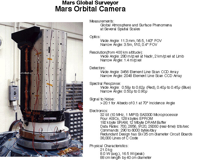
 The Mars Orbiter Camera -- above], according
to data published by the camera's Principal Investigator, Dr. Michael
Malin, in its "narrow-angle mode" is composed of a single line of detectors
-- a "2048 Element Line Scan CCD Array." The Camera produces images by
electronically "cross-track sampling" the array, while the physical motion
of the spacecraft around the planet moves the entire line of detectors
over the Martian surface at right angles to that scan [left].
The Mars Orbiter Camera -- above], according
to data published by the camera's Principal Investigator, Dr. Michael
Malin, in its "narrow-angle mode" is composed of a single line of detectors
-- a "2048 Element Line Scan CCD Array." The Camera produces images by
electronically "cross-track sampling" the array, while the physical motion
of the spacecraft around the planet moves the entire line of detectors
over the Martian surface at right angles to that scan [left].
Inevitably, each individual CCD element in such an array
possesses slightly varying sensitivity compared to its neighboring elements,
across the width of the detector. Thus, any image produced by the "line-scan
CCD array" will inevitably display a series of irregularly-spaced, vertical
bright and dark lines -- like scratches on an old print of "Casablanca"
-- stretching the length of the entire image at right angles to the scan
(below).
Normally, these vertical irregularities are removed from the final image by appropriate computer processing; however, in "raw" or incompletely processed images, these "lines" can serve as unique "detector fingerprints" of that particular CCD array; no two line-scan cameras will imprint the same spacing, intensity, or number of such lines on any of its images. Thus, like matching bullet markings in a murder investigation through a "ballistics test," comparing lines on various CCD line-scan camera images can uniquely determine crucial aspects of those images -- including which camera took which image.
The next day a listener (Fred Hoddick), acting on our conversation about these "CCD idiosyncracies" (as applied to Dr. Malin's camera), began a serious investigation of the earlier Mars Surveyor imagery archived on Dr. Malin's Website [link to Malin's Website]. His results, sent to Enterprise for verification, can only be described as "startling."
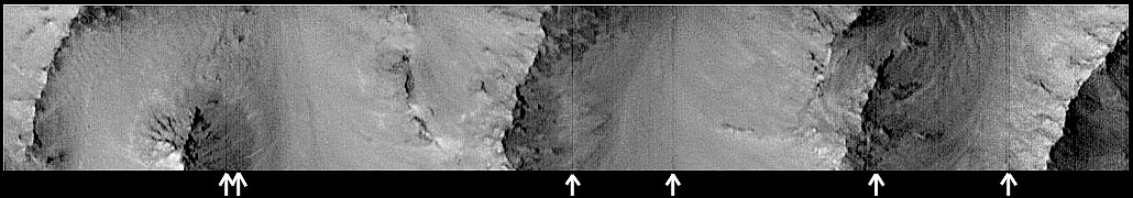
Fred Hoddick discovered that, indeed, Dr. Malin's Narrow-Angle Mars Orbiter Camera imprints a unique "line-scan fingerprint"on every Mars Surveyor photograph; one such image he investigated -- "MOC568174924.8003" -- was acquired by the Mars Surveyor spacecraft on orbit 80: a close-up section of the spectacular "Vallis Marineris,' the so-called "Grand Canyon of Mars." In comparing the "line-scan signature" visible in narrow-angle image "8003" with the pattern of faint lines seen in the "raw" version of the MGS Cydonia image "22003" (see close-up comparisons, below), Hoddick indeed made a major, startling discovery--
That the spatial dimensions of the Mars Surveyor image of Cydonia released by JPL are only half of what should have been acquired!
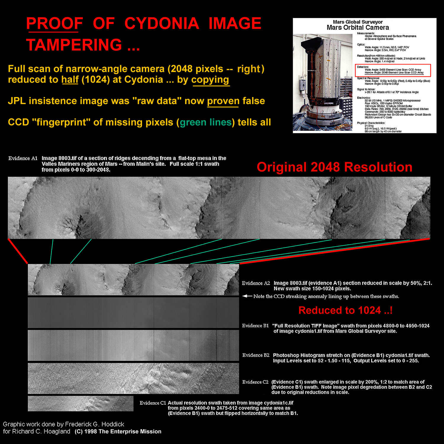
By following the green lines in the diagram and the "image slice" comparisons with earlier MGS frame "8003" (above), it can easily be seen that the final display-resolution of the so-called "raw" Cydonia image "22003" is only half what should have been acquired; the documentation supplied with Dr. Malin's camera (see above) clearly states that the full resolution of a Narrow-Angle frame is supposed to be--
2048 picture elements wide.
 Thus, the "raw" frame displayed on all the NASA Websites only presents
half the spatial resolution data apparently originally imaged by the camera
... radically reducing our ability to detect (if not unambiguously identify!)
any artificial sub-structures present in the image.
Thus, the "raw" frame displayed on all the NASA Websites only presents
half the spatial resolution data apparently originally imaged by the camera
... radically reducing our ability to detect (if not unambiguously identify!)
any artificial sub-structures present in the image.
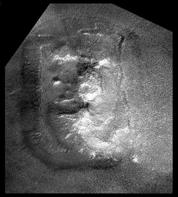
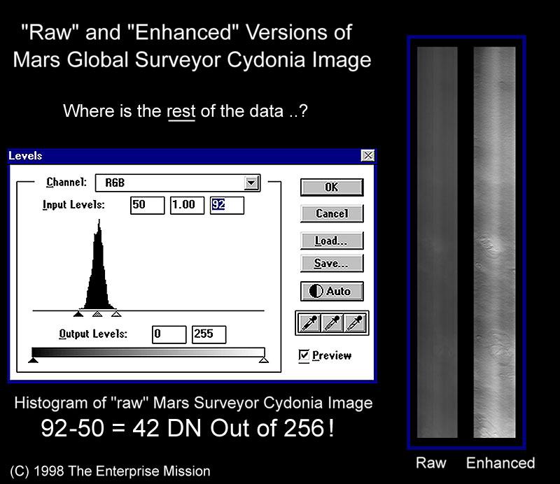
When this blatant spatial "image tampering" is added to the extremely limited grey scale presented in the same MGS "raw" image (see graphic, right) -- which demonstrates that only about 42 grey values are represented out of a possible 256 -- the result is an extremely "noisy" imaging enhancement (right-hand strip). Because of the "morning light" aspect of this MGS Cydonia photography (as compared to the "late afternoon" lighting of the original Viking Cydonia images), this reduced number of grey levels further distorts the "raw" Mars Surveyor Cydonia image ... without a great deal of effort, effectively eliminating meaningful comparisons with the previous Viking data. This comparison is further hampered by NASA's choice of the spacecraft imaging angle -- oblique -- as opposed to Viking's overhead "frontal" view (below).
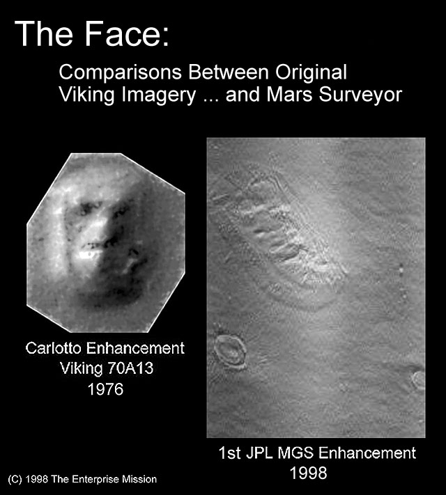 Finally, NASA's curious 1st choice of imaging enhancement tools for this
bland image -- "High-Pass filtering -- effectively eliminated almost all
remaining "grey scale information" in this initial Surveyor picture of
Cydonia -- reducing NASA's first version of "the Face" from Mars Surveyor
to a black and white "cartoon" ... what Art Bell termed whimsically (and
somewhat presciently ...) "the Catbox image."
Finally, NASA's curious 1st choice of imaging enhancement tools for this
bland image -- "High-Pass filtering -- effectively eliminated almost all
remaining "grey scale information" in this initial Surveyor picture of
Cydonia -- reducing NASA's first version of "the Face" from Mars Surveyor
to a black and white "cartoon" ... what Art Bell termed whimsically (and
somewhat presciently ...) "the Catbox image."
No wonder Dan Rather, after one look Monday afternoon,
pronounced it "just another hill ... case closed!"
Michael Malin's response to the posting of our "mysteriously reduced-resolution" discovery came quickly:

Mars Global Surveyor Mars Orbiter Camera
Why is the image of Cydonia only 1024 pixels wide?
This question has been asked a great deal over the past few days. The field-of-view of the MOC is 0.44 , and at the range of the Cydonia image, this translated to about 3.1 km (1.9 miles). The viewing angle was about 45 , so the projected width of the field was about 4.4 km (3 mi). The narrow angle detector is 2048 pixels across, so the intrinsic resolution was about 2.1 m/pixel. The maximum images size (in bytes) is 9.8 MBytes, or 2048 X 4800 pixels. At 2.1 m/pixel, this permitted a down-track field of view of 11 km. Considering the uncertainties in pointing of the spacecraft, this 11 km downtrack dimension was considered insufficient to insure a reasonable chance of hitting the target.There are two ways of extending the downtrack dimension. First, we can use "lossless" compression to extend the distance by a factor of about 1.8. We do this with most of the MOC images. However, losses within the communication system occasionally create black bands (accounting for the loss of about 7-15% of the data) through the images. The MGS Project felt such losses would not be tolerable in the Cydonia images. The second way to increase downtrack dimension is to decrease resolution. If you sum the pixels two by two (that is, replace four pixels--two across by two down--with the average of the four), you can extend the image downtrack by a factor of four. This then changes the dimensions of the image from 2048 X 4800 to 1024 X 9600, and the images covers the same 4.8 km width but extends somewhat over 44 km downtrack. The resolution is lower (4.3 m/pixel vs. 2.1 m/pixel), but the image covers much more ground.
Since this resolution was still substantially better than the best Viking image (by about a factor of ten), the Project decided this was the best compromise in coverage and protection against data loss.
Nice try, Michael -- but no cigar.
After Malin's "response," I spoke with Dr. Thomas Van Flandern, former Head of the Celestial Mechanics Branch of the U.S. Naval Observatory, and a world authority on orbital mechanics. He confirmed my own impressions regarding NASA's main difficulties in its attempted "targeted Mars observations": that the primary navigation problem in securing Mars Surveyor re-imaging of Cydonia (as well as that of Vikings 1&2, and Mars Pathfinder) was "cross-track" (east/west) error, not uncertainties in "downtrack" (north/ south) spacecraft positioning. This was due to the MGS discovery (during the attempted rephotography of Viking) of east/west errors in the map positioning of Mars' "prime meridian" of up to 10 miles!
Thus, to extend the downrange "footprint" of Surveyor's imaging, from slightly under 7 miles to 26 miles, in an ostensible effort to guarantee successfully re-imaging "the Face" -- but at the cost of cutting the surface resolution in the Camera in half -- simply doesn't make sense; by NASA's own acknowledgments, the primary uncertainty in knowing the location of the targets was at right angles to this "increased imaging footprint." For a north/south, polar orbiting spacecraft such as MGS, increasing the "downrange" imaging would have zero effect on the (acknowledged) major cross-track (east/west) errors.
(Such a strategy, however, would make sense if you wanted to decrease the odds of actually recognizing something "interesting" in your field of view ... if you succeeded.)
 And the spectacular success of the JPL Navigation Team confirms this:
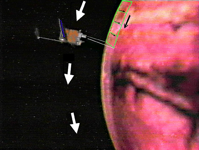
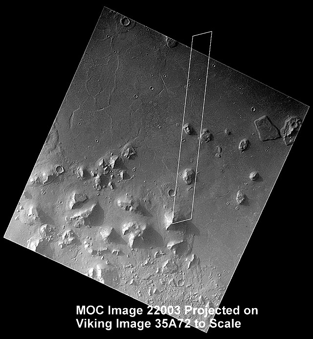
after all of Malin's "explanation," the actual location of "the Face"
in the image JPL released (right) is almost dead center of the "downrange"
footprint, and just left of the east/west "cross-track." (In the words
of one of Malin's own associates on Monday afternoon: "We nailed it!")
And the spectacular success of the JPL Navigation Team confirms this:
after all of Malin's "explanation," the actual location of "the Face"
in the image JPL released (right) is almost dead center of the "downrange"
footprint, and just left of the east/west "cross-track." (In the words
of one of Malin's own associates on Monday afternoon: "We nailed it!")
And other "nagging inconsistencies" also remain ...
If "trading off" imaging resolution for a larger photographic footprint was a deliberate pre-Cydonia strategy reached by the entire Project ... why didn't anyone at NASA (including Michael Malin) tell us before the Cydonia attempt?; why did they wait to offer an explanation for this "surprise" ... until after we discovered it?
This pattern of grudgingly responding to "anomalous details" surrounding the Cydonia rephotography -- and only after they've been pointed out -- is not only increasingly suspicious ... it is highly uncharacteristic of prior NASA behavior as a whole; NASA used to be the one government agency which apparently loved releasing "truck loads" of details about its most arcane activities (some reporters complained, especially during Apollo, about too much detail): everything from the weight of the crawler which carried the Saturn V rocket to the launch pad ... to what the astronauts ate for breakfast ... two days before the launch!
But on the rephotography of Cydonia, NASA's usually copious flood of technical detail has mysteriously dried up ...
Responding to the major criticisms that greeted the first "raw" Cydonia image -- that it simply was too dark -- Dr. Malin posted on his Website (but only after we had presented our histogram analysis -- above) his own assessment, data claiming that the MGS raw image in fact "wasn't all that dark ..."; Malin attempted to compare [link to Malin's Website] the new MOC data of Cydonia with the 22 year-old Viking image histograms, insisting that in truth "the MOC data actually have more grey levels than the Viking images ..." There is only one small problem with Dr. Malin's analysis--
In order to support his claim, Malin had to compare "apples and oranges": the raw "high-sun angle" MOC "morning light" image (22003) to the raw "low-sun angle" 35 A series of Cydonia images from Viking. And the sun-angle difference between the Viking imagery he used and Mars Surveyor's image ... is almost a factor of three lower..!
The Viking image Malin chose to highlight (35A70) was taken just before local "Martian sunset" -- with long shadows (~10 degrees), of an intrinsically dark, relatively contrastless scene; in stark contrast (pun intended ...), the raw Mars Surveyor Cydonia "strip image" was taken at about 10:00AM "local Cydonia time" -- with a sun-angle comparable to the high-sun angle (~30 degrees) of the 70A series of raw Viking frames ... which (although he published a revealing histogram from 70A13) Dr. Malin for some reason conspiciously chose not to focus on ...
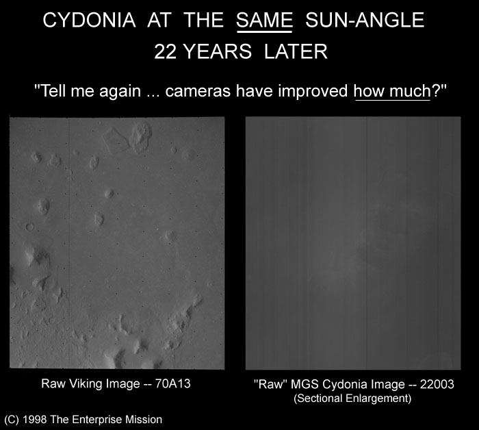 A simple comparison tells why: the visual scene brightness between the
two equally-lit images (see right) reveals an apparently completely different
scene; the
raw Viking image is clearly -- even to the naked eye -- much brighter,
and has far more crucial contrast, than the Mars Surveyor record of the
same scene 22 years later, with ostensibly a far better privately-developed
camera!
A simple comparison tells why: the visual scene brightness between the
two equally-lit images (see right) reveals an apparently completely different
scene; the
raw Viking image is clearly -- even to the naked eye -- much brighter,
and has far more crucial contrast, than the Mars Surveyor record of the
same scene 22 years later, with ostensibly a far better privately-developed
camera!
The difference is literally "night and
day!"
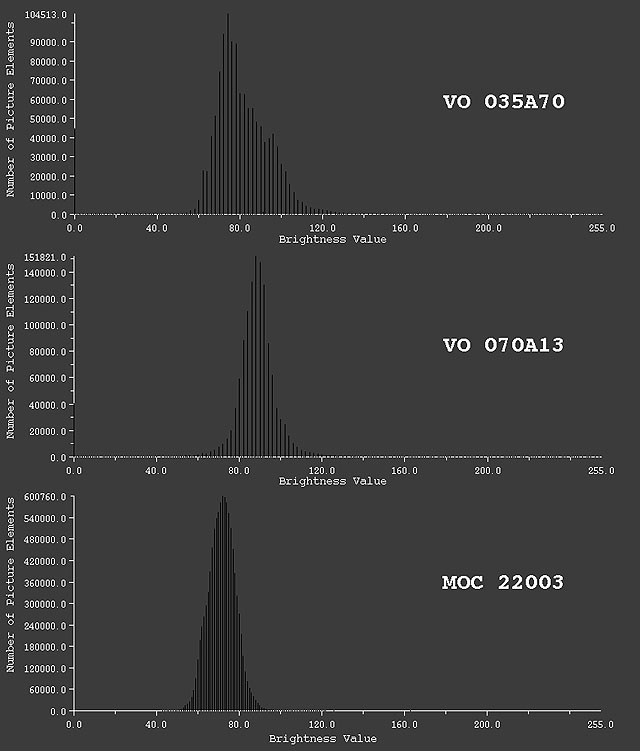 The histogram comparisons reveal the numbers behind this startling comparison
(left); not only are there simply more shades of grey in the image taken
with the "primitive," 20-year old "vidicon tube" TV technology of Viking
(with the sun at essentially the same elevation angle above the horizon!),
but you don't even need a computer to measure it--
The histogram comparisons reveal the numbers behind this startling comparison
(left); not only are there simply more shades of grey in the image taken
with the "primitive," 20-year old "vidicon tube" TV technology of Viking
(with the sun at essentially the same elevation angle above the horizon!),
but you don't even need a computer to measure it--
Just look!
Another of the "Malin explanations" for why the Mars Surveyor image is so dark was "Martian weather."
After initially
writing"... fortuitously, the area imaged was relatively clear," he
then immediately contradicted himself by also stating "the low contrast
of the raw MOC high resolution image ... suggests haze or fog over much
of the area."
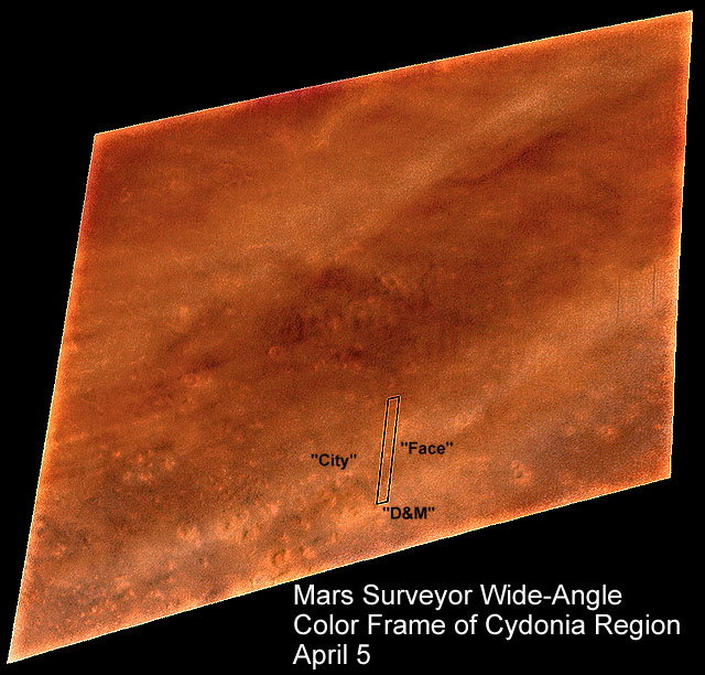 Of the two main problems with this explanation, the first can be seen
in the simultaneous wide-angle, color MGS image that was taken of the
larger Cydonia region that same morning (right). The intrinsic brightness
of this image -- which is caused by well-known "Lambert scattering" from
clouds and haze -- belies the anomalous "darkness" of the "raw" Cydonia
high-resolution frame (outline).
Of the two main problems with this explanation, the first can be seen
in the simultaneous wide-angle, color MGS image that was taken of the
larger Cydonia region that same morning (right). The intrinsic brightness
of this image -- which is caused by well-known "Lambert scattering" from
clouds and haze -- belies the anomalous "darkness" of the "raw" Cydonia
high-resolution frame (outline).
The second problem with MOC 22003, given this wide-angle confirmation of at least some haze over Cydonia that morning, is the fact that the 2048 Narrow Angle Camera CCD detectors (see Camera graphic -- above) have a spectral (color) sensitivity from about 5000 Angstroms (green light) to below 9000 Angstroms (in the infrared). Infrared radiation effectively cuts through haze--
So ...
Why was the long-awaited April 5 Mars Surveyor image of Cydonia so damned dark -- compared to a much more primitive Viking television image of 20 years ago ... 70A13?!
All this notwithstanding, we are left with a growing suspicion: that this first Mars Surveyor, extremely poor quality, Cydonia image ... might not in fact be all that "raw"...
One of the main problems with accepting NASA's assertion that it is, is the growing litany of "ad hoc" explanations NASA has offered after the fact for increasing numbers of technical discrepancies we have discovered and documented with this image -- such as Dr. Malin's somewhat tortured description (above) for why "lossless compression" wasn't used this time within his camera, because of a possible loss of between "7 and 15% of the data ..." But, instead, a certain, 400% reduction in total surface resolution was somehow deemed "acceptable."
What, prey tell, is the relationship between applying a "lossless" compression algorithm in the camera on-board Mars Surveyor ... and experiencing an overall spacraft "communications loss?"; how does reducing image resolution (as a substitute for this on-board "lossless" data compression) thereby reduce those "losses within the communication system [that] occasionally create black bands ..?"
And doesn't reducing overall data acquisition by a certain 400 percent (the effect of the 4-to-1 pixel averaging described by Dr. Malin!) seem a disproportionate response to a potential communications problem which might result in losing a mere " 7-15%?"
(Incidentally, I presume these pesky MGS "communications losses" are in the transmission of the imaging data to Earth, not some internal spacecraft problem between systems. If that is, indeed, the case, in every previous planetary mission I have ever known, losses in telemetry to Earth have been made up by either redundant error-correcting codes, or, by simply retransmitting the same data a second time. And, even if the problem is internal, with no other data in the camera buffer for April 5 except the Cydonia image, why couldn't Dr. Malin simply have retransmitted the same image later ... thus making up for any losses in the first transmission? As far back as I can remember, such redundant procedures have been standard on all previous NASA planetary missions.)
And finally, there is the little matter of the "corrected caption" on JPL's own Website.
as stated on: Mon 04/06/98 10:30 AM PDT Image dimensions: 1024 X 19200 pixels, 4.42 km X 82.94 km
This was a typographical error for which we appologize [sic].
Actual image dimensions: 1024 X 9600 pixels, 4.42 km X 41.5 km
Somehow, it's hard to imagine anyone typing "19200" in place of "9600" -- even in a government contracted typing pool at JPL. But--
If the original transmitted imaging resolution from Dr. Malin's camera was 2048 pixels across, subsequently "downsized" on Earth to 1024, then the corresponding "downtrack" dimension would have been precisely 19200 pixels -- exactly what the original NASA caption read ... exactly consistent with our discovery that "MOC 22003" is somehow missing 400 percent of its expected resolution.
The only question remaining: was the resolution deliberately "traded off" at Mars in Dr. Malin's camera (as he claims), or was it quietly reduced in the production of a second generation copy -- the impossibly bad "raw" image we were given Monday -- of the original, high-quality 2048 X 19200 image ... here on Earth?
Several hours after the JPL release of the "raw" Cydonia MGS image, and several additional hours after the release of the "enhanced" ("Catbox") version that the media all took one look at ... and totally dismissed--
A new Cydonia image suddenly appeared on all the NASA Websites -- termed the "TJP Enhancement".
Presented by a NASA geologist officially attached to the Mars Pathfinder mission, this enhancement by Tim Parker was a staggering improvement over JPL's first "high-pass filter" version. Unfortunately, by the time Mr. Parker's partially rectified, grey-scale corrected version -- confirming a startling "face-like" image at Cydonia -- was posted on NASA's official Websites all around the world.... no one in the media was listening (or, apparently, even watching NASA's Websites).
Where did this remarkable "new" Cydonia image come from? Was it merely another "enhancement" of the previous "raw" image released that morning (as Parker insisted in his own "enhancement notes" accompanying the image) ... or, was it drawn from data much closer to what Mars Surveyor actually transmitted back to earth?
We may never know.
Which only underscores the point I've been attempting to illustrate all week:
That, without appropriate and meticulous documentation of the entire process -- from taking the photographs at Mars, to receiving, enhancing and displaying them back here on Earth -- no one can make a scientific assessment of what's waiting at Cydonia ... In terms of Mars Surveyor, judging from our experience this week, we are still "light years" from gaining access to such crucial, verifiable documentation.
So far, unlike any other area of Science, on the subject of potential Life on Mars we're simply being asked by NASA (and its contractors) "take our word ..."
When I was at CBS, covering Apollo, a correspondent in our unit once wise-cracked in frustration that, " NASA' simply means Never A Straight Answer ..."
I guess it still applies.