A NEW MODEL OF MARS AS A FORMER CAPTURED SATELLITE:
BI-MODAL DISTRIBUTION OF KEY FEATURES
DUE TO ANCIENT TIDAL STRESS?
Richard C. Hoagland
(Principal Investigator,
Enterprise Mission)
Michael Bara
(Executive Director, Formal
Action Committee on Extraterrestrial Studies).
ABSTRACT
Conventional models of Mars, based on measurements by initial Mariner unmanned spacecraft, found an arid, apparently ancient environment without current liquid water. This prompted subsequent, highly negative assessments regarding Mars history, and the difficulty for the origin and/or evolution of higher forms of life. Later, the unmanned Viking missions (as well as the 1997 Pathfinder Lander) seemed to confirm this barren model. Complex, sometimes contradictory geologic theories to explain this desolate Mars environment have been proposed, based on a wide variety of observed surface phenomena and features. A new model that reconciles major puzzling contradictions among past models is now put forth, using new observations from MGS high-resolution images of Mars and a reevaluation of certain Viking era experiments. Small-scale surface features are identified which, it is proposed, are the direct product of wide spread ancient and recent bursts of subsurface liquid water. These water stains are shown to cluster (beyond statistical chance) in an unmistakable tidally-determined, bi-modal distribution on the planet: centered near the Tharsis and antipodal Arabia bulges. A revaluation of Mars ancient history is therefore proposed, suggesting that Mars (well after solar system formation) was captured into synchronous orbital lock with a larger planetary companion (Planet V), accounting for the clustering of present day water bursts around the former beds of two bi-modally distributed Mars ancient oceans as a direct result. The current Tharsis and Arabia mantle uplifts are shown to be an inevitable additional fossil signature of such former tidal stresses, induced by a close gravitational relationship with Planet V. Other heretofore inexplicable Martian surface features are shown to be consistent with such a simple "tidal model": Valles Marineris (as an eroded ancient tidal bore, formed immediately post-capture); the presence of the extremely flat terrain covering the northern hemisphere (via deposited sediments from the once tidally supported oceans, when released); and the current trench or "moat" around the Tharsis bulge (from relaxation of Tharsis back into the mantle, after tidal lock was broken). The long-mysterious Line of Dichotomy is explained as a remnant of a blast wave of debris from this sudden severing of the former orbital lock relationship with Planet V, due to either a catastrophic collision or explosion. Chemical signatures of this extraordinary destruction event on Mars are shown to be consistent with the model; including the distribution of olivine preferentially below the line of dichotomy; the presence of primitive mantle and core materials such as iron and sulfur in unusual abundance on Mars surface; and the concentration of proposed water stains in areas bereft of olivine. Mars unusual magnetic field striping is now shown to be another unique southern hemisphere signature of this destruction event, caused by standing P and S waves reverberating through the planets crust as a result of the massive simultaneous impacts from Planet V debris. Recently published research showing unprecedented outflow channels from the Tharsis and Arabia bulges are shown to be consistent with the sudden relaxation of the two tidal oceans, as is the sculpting of huge amounts of material by fluvial processes north of the Arabia bulge. Two possible mechanisms for the destruction of Planet V and the breaking of this tidal lock are outlined. Finally, a new timeline for Mars geologic evolution is proposed that is consistent with these observations, placing these events between capture ~500 MYA and the destruction of Planet V at 65 MYA.
Introduction
Mans fascination with Mars has led
to many fanciful and romantic notions about the planets genesis.
Early popular (and even some scientific) speculations focused
on a planet populated by exotic creatures if not warring advanced civilizations;
these were based in large part on Lowells turn-of-the-Century model
of a harsh and frigid Mars, one that was still habitable, though dying. It was not until the 1964 Mariner 4 mission
that the general public and the scientific community got their first
close-up view of the real Mars -- as Mariner 4 flew by at a distance
of 6,118 miles. The 21 images
telemetered back to JPL surprisingly revealed a cratered terrain more
akin to the lifeless lunar surface than anything on Earth.
With these first insitu spacecraft Mars data, hopes for finding
anything approaching another Earth elsewhere in this solar system
were permanently dashed. Subsequent missions confirmed that the Martian
atmosphere was much too thin and the temperatures too low to allow for
the presence of surface liquid water, eliminating almost any remaining
hope of finding current life.
Eleven
years later, biology experiments conducted in 1976 by the Viking Landers
(including one termed the Labeled Release Experiment, or LRE), produced
positive results for life bearing organisms in the samples.
[1]
However, these findings were directly contradicted
by other instruments results, which indicated that the biology data
were false positives, generated by a non-biological chemical reaction
with the Martian soil.
[2]
Among the principal reasons cited for consensus
against the LRE was the absence of available liquid water on the Martian
surface a key prerequisite
for life. This general dismissal
of the LRE results was immediately challenged by the LREs Principal
Investigator, Gilbert Levin. Levin
[3]
showed that liquid water could flow on the present
day Martian surface, if the available water was restricted to the lower
1-3 km of atmosphere, rather than being evenly distributed throughout
its depth. Meteorological data
from Mars Pathfinder later confirmed the Levin model for atmospheric
water distribution.
[4]
One
remarkable development in this regard has been the rediscovery of 25-year-old
lost NASA data from Levins own experiment.
Joseph Miller, a neurobiologist at the University of Southern
California, recently presented evidence that the radioactive C02 release
that was the heart of Levins experiment exhibited a clear 24.66-hour
Martian diurnal cycle precisely the circadian rhythm to be
expected of living Martian microbes in the soil.
[5]
If confirmed, this would strongly indicate
current microbial organisms on Mars despite a quarter-century of disclaimers
and the apparent dearth of liquid water.
In
striking contrast to the current apparent aridity of Mars, analysis
of images from Mariner 9 and Vikings later Orbiters did reveal evidence
of large and catastrophic ancient water flows on Mars.
They also revealed evidence of a violent geological past -- with
huge volcanoes, extensive cratering in the southern hemisphere, and
a massive canyon system (Valles Marineris) stretching almost one-quarter
of the way around the planet.
Despite
evidence of wide-spread water flows on Mars, the general scientific
consensus now is that any liquid water on the planet has been confined
to the very distant past (circa 3 plus billion years -- GYA), when a
much denser atmosphere allowed it to flow freely across the surface.
The presence of large numbers of eroded craters in the south
is cited as proof that the planet has been geologically dead for at
least 3 billion years -- the time since the last heavy bombardment
of the inner solar system.
[6]
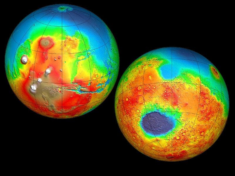
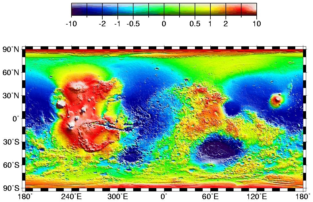
Figure 1 - MOLA colorized image of Mars showing the heavily cratered southern highlands (yellow and orange) and the smooth, sparsely cratered northern lowlands (blue and green).
Other
surface features present more difficult problems for geologists. There
are vast differences in crater densities between the northern and southern
planetary hemispheres. In the North, medium-sized craters are rarely
seen, with significant distances between them. This is in distinct contrast with the South, where craters are so
numerous that they overlap each other, making it difficult to distinguish
between individual impacts. This
stark difference is mysteriously emphasized by a Line of Dichotomy:
a separation line running around the circumference of the planet at
about a 35-degree angle to the Equator.
The southern, heavily cratered side of the line, is also (mysteriously)
nearly 30 kilometers (on average) higher than the northern sparsely
cratered lowlands.
Somewhat
limited by existing theories of solar system formation, planetary geologists
have tried to explain these major discrepancies on Mars in terms of
familiar models. Since the northern hemisphere accounts for
50% of the land mass but only 7% of the craters, the latest idea is
that Mars must have lost its primordial crust in the northern hemisphere
to an ancient
period of vigorous convection and high heat flow
[7]
early
in Martian history, at a time
well after the last heavy bombardment period.
However, the lack of smaller craters on the northern plains (based
on relative dating of similar cratering statistics from the Moon) paradoxically
implies a relatively recent date for this proposed event.
An Alternative Model of Solar System Evolution
In
1978, Naval Observatory astronomer and celestial mechanics expert, Thomas
Van Flandern, put forth the idea (based on an original model by
Olbers) that a relatively recent exploded planet in the asteroid belt
between Mars and Jupiter was responsible for the origins of most comets
and asteroids in the solar system.
[8]
This notion, called the Exploded Planet Hypothesis
(EPH)
[9]
, has found little support in the planetary science
community, but its lines of evidence since its initial publication over
twenty years ago have become increasingly compelling.
Part and parcel to this hypothesis is the idea that half Mars
visible surface was devastated by this proposed explosion event, neatly
accounting for the cratering dichotomy between the northern and southern
hemispheres, and the loss of a once dense and possibly life sustaining
atmosphere.
More
recently, writer Graham Hancock has popularized an alternative catastrophic
theory, which supports the conventional view that the north was stripped
of several layers of primordial crust.
[10]
Hancock argues that a large comet or planetoid
somehow wandered into the Roche limit zone of Mars and was drawn into
the planet in the Hellas basin, effectively tearing away the older surface
of the northern hemisphere via secondary bombardment, and depositing
the remnants of its shattered bulk into the southern highlands. Hancocks idea is based on Donald W. Patten and Samuel L. Windsors
research,
[11]
who surmise that this object was in fact a rogue
planet they call Astra, described in their book The Scars of Mars.
There are however numerous problems with the Astra concept
for instance, it cannot account for the presence of the asteroid belt,
while the EPH does so intrinsically.
The authors of this paper believe that the EPH is the much stronger
hypothesis (if appropriately modified), and that it has already demonstrated
a capacity to survive serious falsification efforts, qualities not shared
by Astra.
Extension of the EPH
Recently, Van Flandern has extended the EPH to include
the notion that several planets (Pluto, Mercury, and Mars) are actually
former moons of current or destroyed planets. Evidence to support this hypothesis is extensive,
but for our purposes we will focus exclusively on the evidence for Mars. Of these lines of evidence, we will address
here only a few as relevant to our proposal.
A more complete analysis will be left to a followon paper. Some of the evidence, as compiled by Van Flandern:
Dorman
& Woolfson (1977), writing in the Philosophical Transactions of
the Royal Society of London, resented a model called the Capture Theory
of Planetary Formation. They proposed that Mars was once an original
(not captured) moon of one of two colliding protoplanets in the early
accretion solar system phase.
[12]
They even provided one specific piece of evidence
to support their idea that Mars began as such a satellite: Mars density
is much closer to that of some of the Galilean satellites than it is
to Venus, the least dense inner planet.
This implies a genesis more in common with Io, Europa and Earths
Moon than with the terrestrial planets.
To quote Woolfson (1984):
As part of the [Capture Theory] scenario, it has been suggested that Mars was originally a satellite of one of the colliding planets. The densities of the terrestrial bodies and some larger satellites are shown in support of this suggestion (Figure 2). Connell & Woolfson (1983) have ascribed the hemispherical asymmetry of Mars, like that of the Moon, to abrasion by high-speed ejecta from the planetary collision of that face of the satellite turned toward its primary. This will give rise to a thinning of the crust and for Mars such features as the centre-of-mass centre of figure offset are well explained by this. If Mars as a satellite was in synchronous rotation about its primary then this mechanism would suggest that its spin axis should be contained in the plane of asymmetry, but it is actually 55 degrees [the 35 degree line of dichotomy, minus 90 degrees] to that plane [emphasis added].
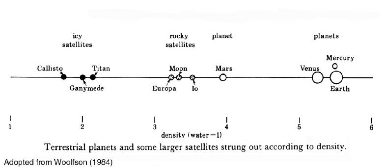
Figure 2 - Terrestrial planets and larger satellites listed according to density. Mars is much closer to Earths Moon, Io, and Europa in density than it is to Venus, the first major terrestrial planet listed.
Van
Flanderns EPH Model proposes that there were formerly two massive planetary
bodies in the current orbits of Mars and the Asteroid Belt, respectively. Both exploded. The first (Planet K) detonated in the orbit of the current Belt
several hundred million years ago.
The second (Planet V) exploded near the present day orbit of
Mars, some 65 million years ago (MYA).
In Van Flanderns theory, additional impact damage was done to
Mars when a much smaller second former moon of Planet V exploded
in Mars vicinity 3.2 MYA. In
our modification of the EPH, we will show that it is not necessary to
invoke a literal planetary explosion to produce all the subsequent
effects Van Flandern has proposed, including the formation of asteroids
and comets, and the escape of most of the remaining mass from solar
influence. In doing so, we will
draw upon new data not available when Van Flandern originally formulated
his EPH ideas, specifically, observations of certain Extra Solar planets
that follow orbits similar to what we are proposing led to Mars initial
capture as a satellite, and then the destruction of its foster parent,
Planet V.
The relevance of water
If Mars, prior to its capture (in our
model) formerly had a denser atmosphere that provided for liquid water
on the surface, it is likely that this water dependent on the amount
-- was distributed in lakes or oceans, much as it is here on Earth. If this was the case, there should still be pockets of this water
trapped beneath those former lake or ocean beds, relatively close to
the surface, dependent on how long ago the water actually flowed. If extensive fields of this frozen or (sometimes)
liquid water were discovered near the surface, this would strongly imply
such former lakes or oceans were the source.
Besides
Levins atmospheric model, the best evidence for current liquid water
near the surface of Mars (until recently) was provided by Dr. Leonard
Martin of the Lowell Observatory. Martin, in 1980, compared two images of Mars
taken from the Viking Orbiters that clearly showed an erupting water
spout.
[13]
This implied active geothermal heating of a
source of water not too far below the current Martian surface.
In June 2000, Michael Malin and Ken Edgett of MSSS published a paper in Science [14] , proposing that grooved features on cliffs and gullies on Mars were fossil evidence of prior erosive runoff from liquid water. They placed the events as recently as 1 MYA, but conceded the bursts could also include present day occurrences.
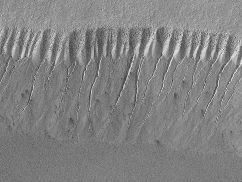
Figure 3 Proposed fossilized water runoff channels. (MSSS/NASA)
In 1998, one
of a growing number of independent researchers, Byran Butcher, noticed
and published on the Internet a curious dark area. He casually suggested it might be a coffee stain, water, or a shadow.
[15]
In July 2000, the authors published a much
more specific model, based on an MOC image of an unusually dark, highly
elongated stain emanating from an exterior point source on a crater
wall, proposing that it was a current water flow consistent with the
model Malin and Edgett had put forth a few days earlier.
[16]
They quickly found numerous additional examples.
Figure 4 Proposed point source liquid water burst image from MO4-00072 (MSSS/NASA)
Subsequent
to this, Palermo, England and Moore also found that surface stains
were inconsistent with aeolian features, mass wasting or other non-fluvial
processes.
[17]
At the suggestion of one of the authors (Hoagland),
Palermo et-al then proceeded to systematically map the locations of
these seep images relative to Mars surface coordinates, to see if
there was a global pattern to their distribution.
As a control, they also mapped randomly-selected non-stain
images until a representative and statistically valid sampling had been
completed.
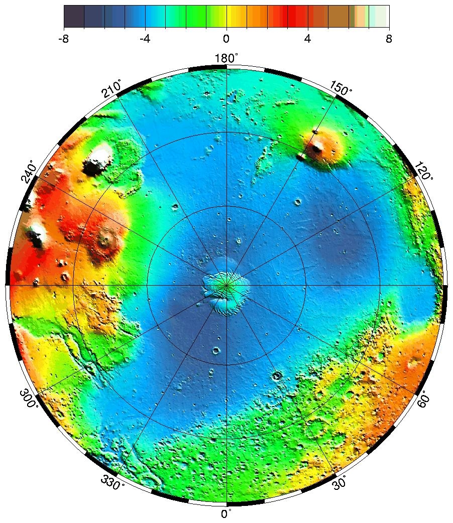
Immediately, two striking global patterns emerged: both pointing to present day liquid water as a source of the stains or seepages. In the first pattern, the map showed that seepage images seem to appear preferentially near equatorial latitudes, mostly between 30 degrees North and South; none were found above 40 degrees North and South. This implies that the phenomenon is restricted to warmer areas of Mars, which would be expected if these were truly water flows. An equatorial pattern is also inconsistent with the dust avalanche model put forth by Malin and NASA as an explanation for these features. [18]
Figure 5 Map showing flow image distribution.
The second, more
important pattern discovered was that the water flows seemed to cluster
preferentially around two pronounced geological features on the Martian
surface: the Tharsis and Arabia mantle uplifts (bulges -- Figure 5). The theoretical factors behind this second (and very pronounced)
bi-modal stain distribution pattern are the primary subjects of this
paper.
Mars as a Tidal Locked Moon of a Companion Body
The authors are proposing in this paper
that Mars, at some point earlier in solar system history, was captured
by one of two larger planetary bodies orbiting near the present day
orbit of Mars. This scenario
is an extension of the Capture Theory model of solar system formation
put forth by Dorman & Woolfson (1977), as well as Van Flanderns
Exploded Planet Hypothesis (1978).
It is also based on current observations of significantly elliptical
orbits for many newly-discovered Extra Solar planets around nearby stars,
as reported by Butler, et-al.
[19]
One relevant example is the Jupiter-massed
planet orbiting the nearby K-type star, Epsilon Eridani. With an orbital period of 6.9 years, an orbital
eccentricity of 0.6, and an average distance from its star of 3.4 astronomical
units (AU), this planets orbit would take it as far out as Jupiter
and as close as Mars if it orbited in our own solar system.
[20]
It
is our proposal that two previous planets in the vast gap between
the current orbits of Jupiter and Mars, with orbital eccentricities
far less than the Epsilon Eridani planet, after several billion years
were gradually perturbed into a series of close encounters.
This eventually resulted in the low-probability but possible
three-body capture of a third object, the formerly freely orbiting
Mars, and millions of years later, the actual collision of the two larger
planets. As noted, such theoretical
former solar system members have been referred to as Planet K and
Planet V in Van Flanderns original EPH model, the latter estimated
to possess approximately 4-5 Earth masses.
We
propose that, like theoretical models invoked now to explain some Extra
Solar System observations of formerly interacting planets,
[21]
a rare multi-planet encounter occurred late in solar
system history between two planets formerly occupying the current gap
between Jupiter and Mars: two massive terrestrial planets termed K
and V. As a result, Mars was robbed of a critical portion of its solar
angular momentum, allowing capture in an extreme elliptical orbit as
a new satellite of Planet V.
An
alternative scenario involves only one former solar system member
Planet V.
Given
the parameters of existing solar system members -- distance, density,
and mass, especially Mars low density compared to the other terrestrial
planets (Figure 2) -- it seems reasonable to assume that if two additional
Earth-massed planets had formed between Jupiter and Mars, they would
have incorporated significantly more water than did Earth.
And, given the increased likelihood of multiple glancing collisions
in the early planetesimal phase for this region of the solar system,
[22]
they probably possessed multiple natural satellites
as well. An encounter of Mars with such a system, billions
of years after its formation (as we are proposing), would thus have
a reasonable probability of encountering a satellite as well. This type of encounter has a much higher probability of happening
than the previous scenario presented (the three-body interaction of
Planet K, Planet V, and Mars). But,
this second type of encounter could also result in Mars being captured
by Planet V via the ejection of one of Planet Vs own moons. Calculations examining similar scenarios have been performed in
connection with the anomalous Neptune system which consists now of
a major planet-sized satellite (Triton) in retrograde orbit, and a smaller
moon (Nereid) in a highly elliptical one.
This has been viewed for years as prima-facie evidence for a
highly unusual Neptune encounter earlier in solar system history with
an outside object in heliocentric orbit, which reversed Tritons orbit
and ejected a previous moon from the system entirely.
That escaped satellite is now known as Pluto.
[23]
Figure 6 Mars captured by the larger Planet V and brought into a tidal lock relationship, with gravitational bulges developing on opposite sides of Mars, 90 degrees to the spin axis of Planet V. Bulges precisely correspond to the Tharsis and Arabia bulges, 180 degrees apart.
Regardless of the precise methodology of capture, the subsequent, strong tidal relationship between Mars and the more massive Planet V (Figure 6) would have resulted in a further, rapid loss of Mars spin angular momentum, from a free rotation period in solar orbit on the order of ~12 hours down to the presently observed ~24. This estimate is based on models of Earths primordial rotation slowed by early lunar tides ( Figure 7). [24] In the model, inevitable tidal evolution not only ultimately circularized Mars orbit around Planet V, it resulted in Mars finally rotating/revolving around Planet V synchronously, in approximately 24 hours -- with one side always facing Planet V, as Earths Moon does today.
Figure 7 - Growth increments of fossils and tidal sediments on Earth record
a significantly shorter day as one moves further back in time.
It is the authors
central proposal in this paper that it was this verifiable Mars tidal
lock relationship with Planet V that accounts for a host of previously
inexplicable and even contradictory Martian surface features, that otherwise
will remain perpetually mysterious.
This begins with the otherwise baffling present-day Tharsis and Arabia antipodal uplifts on the planet, which are located precisely 180 degrees opposite (Figures 8 and 9). In this tidal model, the Tharsis bulge -- a huge upwelling in the mantle and crust of Mars, unique in the solar system is explained as a combination of the extended gravitational tidal influence of the larger Planet V acting for a significant period of time on that hemisphere, in concert with pre-existing internal mantle upwellings. As would be expected from such a tidal situation, a smaller but still significant anti-bulge would inevitably be raised at the antipodal location to Tharsis -- which accounts for the Arabia uplift precisely 180 degrees around the planet.
|
|
|
All formerly fluid or partially fluid bodies in the solar system, including the inner moons of Jupiter and Saturn, show signs of such tidal evolution. Io, in particular, has significant bi-modal tidal bulges, similar to the model we are proposing now for Mars. [25] We additionally postulate that other heretofore inexplicable geologic features, such as Valles Marineris and the Elysium Mons, were also an extended result of this former tidal mechanism. The authors also propose that, when this tidal lock relationship was severed -- by the events directly leading to the destruction of Planet V -- Mars rotational polar axis obliquity, relative to the plane of its satellite orbit, dramatically shifted. This sudden obliquity shift, as part of this rapidly timed sequence of events, is responsible in the model for the apparent discrepancy of the Line of Dichotomy blast wave being inclined about 55 degrees to that rotational axis -- instead of being focused on the Tharsis region itself (see details, below).
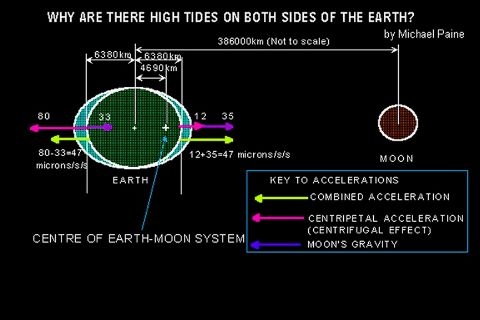
Example of typical anti-podal tidal bulge on Earth
Original capture model and consequences
After capture, as this close orbital
relationship between Mars and Planet V evolved and the orbit circularized
over hundreds of thousands or even millions of years, any surface water
of oceanic volume would have sloshed back and forth across the surface
of Mars twice every Martian day, just as lunar tides do here on Earth. We assert, based on this intrinsic tidal process,
that Mars at the time of capture had to have been a warm, wet world
with both a denser atmosphere and a copious supply of flowing liquid
water, otherwise it would not evidence the major surface signatures
of tidal movement we will demonstrate.
But first: as an
intrinsic aspect of this model, we begin by proposing that the puzzling
mantle uplift of Tharsis began long before this dynamic capture sequence
culminated. Once Mars was captured
and oriented with the pre-capture heavy side (Tharsis) pointed down
(toward Planet V), the uplift process was then further and extensively
augmented by the stretching gravitational forces of Planet V close
by. Further, we suggest that this process resulted
in the relatively brittle crust of Mars weakening at the eastern base
of the now stretched Tharsis rise, resulting in a series of radial fissures
opening up one of which was then radically enlarged to become the
Valles Marineris canyon system.

Figure 10 A typical terrestrial tidal bore wave making its way up a river basin.
In the model, this original tension crack was inevitably expanded by the erosive effects of a massive volume of directed tidal waters termed a tidal bore [26] (Figure 10) -- rushing back and forth (at several hundred kilometers per hour!) the entire ~ 1600 kilometer plus length of the original fissure, twice each Martian day, in direct response to the original spin rate of Mars and the massive gravitational tides caused by Planet V. Before Mars tidal lock with the larger planet was achieved, this enormous surge would have flowed, always westward, around the circumference of Mars in the direction opposite Mars spin, until it piled up against the immobile eastern side of the pre-capture Tharsis bulge. At that point, when high tide passed, the released waters would have rushed (under Mars gravity) back down the canyon system toward the east, scouring the floor once more, until the next high tide. This almost unimaginable force of rushing water, through an expanding canyon system of parallel fissures eventually opened up by the fluvial erosion, would have recurred twice each Martian day, possibly for several million years -- until Mars rotation was finally stationary relative to Planet V.
Figure 11 Valles Marineris, a heretofore inexplicable trough extending one quarter of the circumference of Mars, is the largest canyon in the Solar System. The authors submit that this a fluvial trench generated by tidal bore action during Mars captured satellite phase.
It
is our proposal that this scrubbing action eventually resulted in
a radical deepening of the original narrow cleft to form the present
day ~7-km-deep, ~4000-km-long canyon system known as Valles Marineris
a system (Figure 11) now stretching one quarter of the way around
the planet Mars.
This
assumes that Mars, like the other planets of the solar system, prior
to its capture had a prograde spin.
Thus, the tides induced by Planet V forced the rising and falling
waters to always assault the eastern side of Tharsis which
is precisely where Valles Marineris formed.
The newly-found bi-modal clustering of stains (current water flows) exclusively in the Tharsis and Arabia regions of the planet by Palermo (2001), 180 degrees apart, is an additional major indicator that this model is correct. This accounts not only for tidal bi-modal crustal deformation of the planet, as predicted by the satellite model, but also implies that major quantities of unevenly distributed fluid (water) once also existed on the surface. Presumably, this water primarily resided after tidal lock in two opposing tidal ocean bulges with possible dry land between -- because of the inevitable bi-lobed tidal forces experienced by Mars as an ultimately synchronously rotating satellite of Planet V.
The evidence argues that, once Mars lost its remaining
spin momentum and established this stable synchronous orbital relationship, this was not broken or adjusted
significantly until the catastrophic destruction of Planet V. The constant tidal tugging on the two opposing
hemispheres of Mars from this synchronous orientation now resulted in
a continual uplift of the Tharsis region, and to a lesser extent Arabia,
antipodal to the Tharsis rise. The
formerly racing tides would also then have stabilized, and the tidal
erosion of Valles Marineris would have totally subsided.
At this point, the only additional fluvial erosion processes
likely on the planet would have been wind-induced wave action and severe
storms. Evidence of the former should still present itself on some key surface
features not altered by the subsequent Planet V destruction.
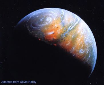
Figure 12 Artists conception of Mars as it might have appeared during its Garden of Eden period, after capture by Planet V.
One potential candidate for such erosive
signatures is Olympus Mons itself. Olympus Mons rises some 24 kilometers high
and measures 550 km in diameter, making it the largest shield volcano
in the solar system. According
to our model, a significant portion of this volcano most likely stood
above the water-line of this ancient Tharsis Ocean, and should still
display signs of aeolian wave action.
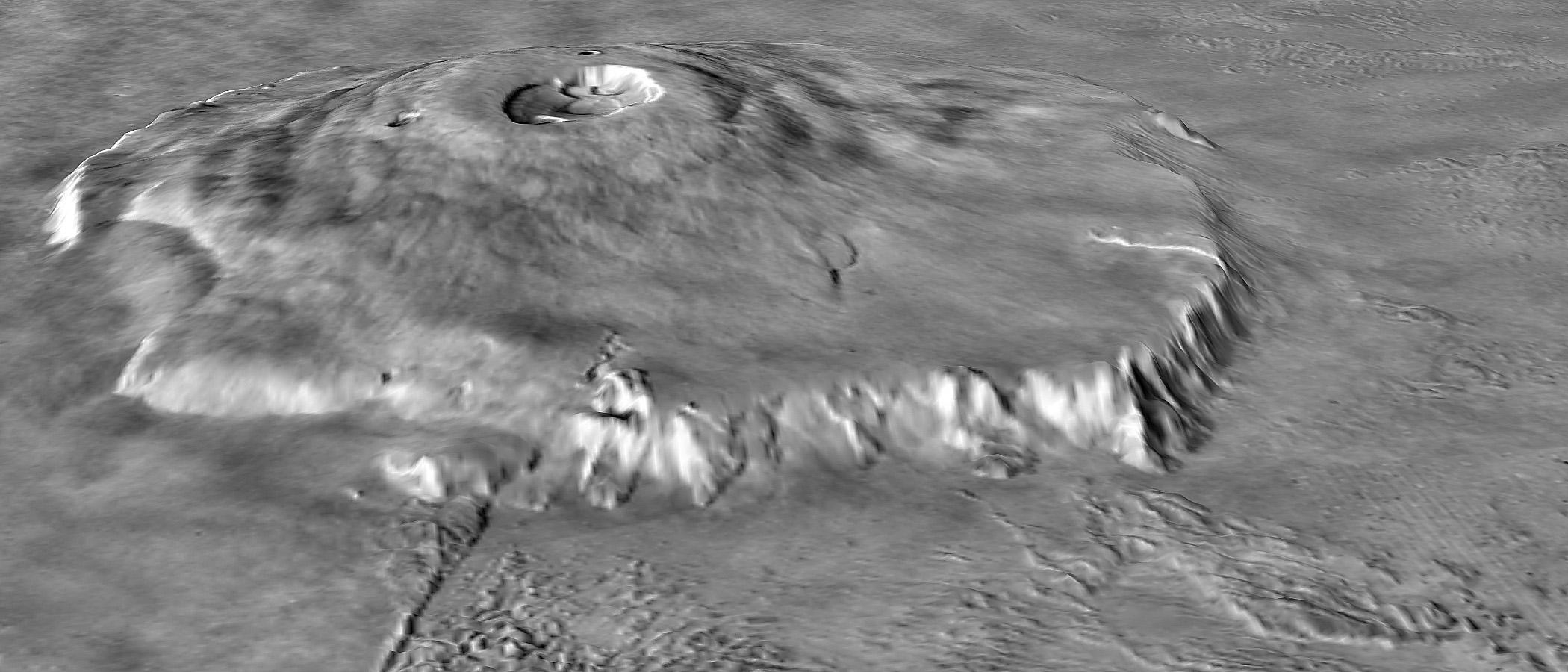
Figure 13 Olympus Mons 3D perspective image showing prominent vertical scarp at the base of the lower flanks (NASA).
Remarkably,
Olympus Mons is almost completely encircled by a very steep, nearly
vertical escarpment. This scarp ranges from between 2-10 km high,
[27]
indicating that it was carved out over time as the
volcano was pulled/pushed upward by the continuing tidal force of Planet
V aiding internal planetary uplift.
The vertical walls of the scarp suggest that it was created by
this proposed aeolian wave action, as it bears a strong resemblance
to similarly vertical, wind/wave action features on Earth.
Ironically, this idea was first proposed in a somewhat modified
form in 1973, by University of Pennsylvania geologist, the late Henry
Faul. Titled romantically The
Cliff of Nix Olympica (the pre-Viking name for Olympus Mons), the paper
was never accepted for publication because of the paucity of data.
[28]
The Viking and MGS missions have now remedied
that situation, and we hope that Henry Fauls remarkable idea is finally
given its appropriate hearing.
The White Cliffs
of Dover (Figure 14) are a prime terrestrial example of such features. These lime-rock vertical cliffs are created
by the action of the waters of the English Channel. High winds in the Channel create a constant bashing action on the
shore rocks, eventually beating the rocks to a vertical face. Similar features are seen across the Channel
on the coast of France.
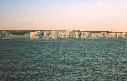
Figure 14 The White Cliffs of Dover, a vertical, aeolian wave action feature on Earth.
Further evidence that the Olympus Mons scarp feature is due to the wind-driven action of an ocean can be found in the fact that it envelops the entire mountain (Figure 15); if a hypothetical ocean surrounded such a rising tectonic feature, the wind/ocean patterns would be expected to erode a mostly uniform scarp such as the one we see.
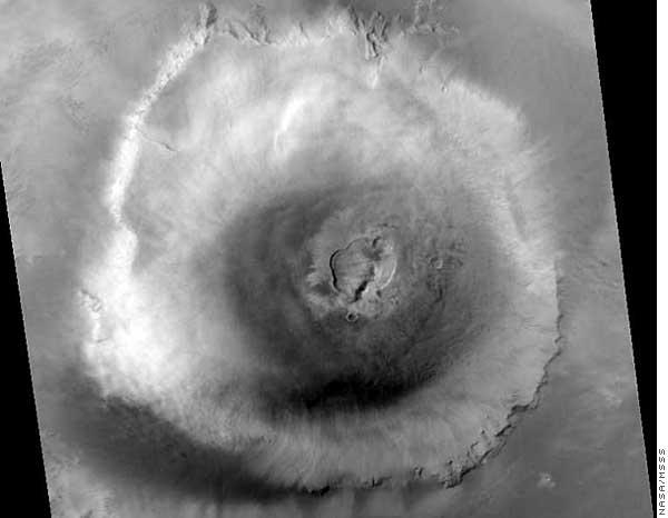
Figure 15 Overhead view of Olympus Mons from Mars Global Surveyor. Prominent vertical scarp nearly encircles the base (NASA/MSSS).
It is also likely
the scarp was formed after Mars assumed synchronous tidal lock around
Planet V, since it does not appear to be a result of directional tidal
forces. If the scarp was tidal, it is likely the cliffs
on its circumference would be significantly more pronounced on the eastern
side. Intriguingly, Arthur Clarke
several years ago created a computer-generated image (Figure 16) depicting
precisely such an Olympus Ocean.
Although projected to a time when humans have terraformed the
planet Mars, his depiction especially the waters swirling around the
22,000 foot-high cliff around the mountain are eerily accurate to
our own model of a former tidal Mars.
[29]
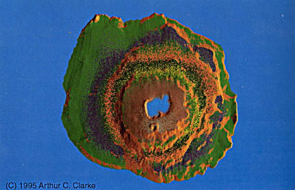
Figure 16 Arthur C. Clarkes projection of an Olympus Ocean lapping at the 22,000 foot-high-cliffs surround Olympus Mons
Stain Distribution
A major, long-term consequence of this eventual Mars synchronous rotation around Planet V is the present bi-modal distribution of subsurface water stains. The tidal forces from Planet V would have pushed water into sub-crustal fissures and cavities at right angles to the exerted tidal stress between Mars and Planet V (Figure 17). Over time, this would have driven additional Martian water in between the two tidal oceans deep underground and toward one of the two water poles at either end of the line connecting Mars with Planet V.
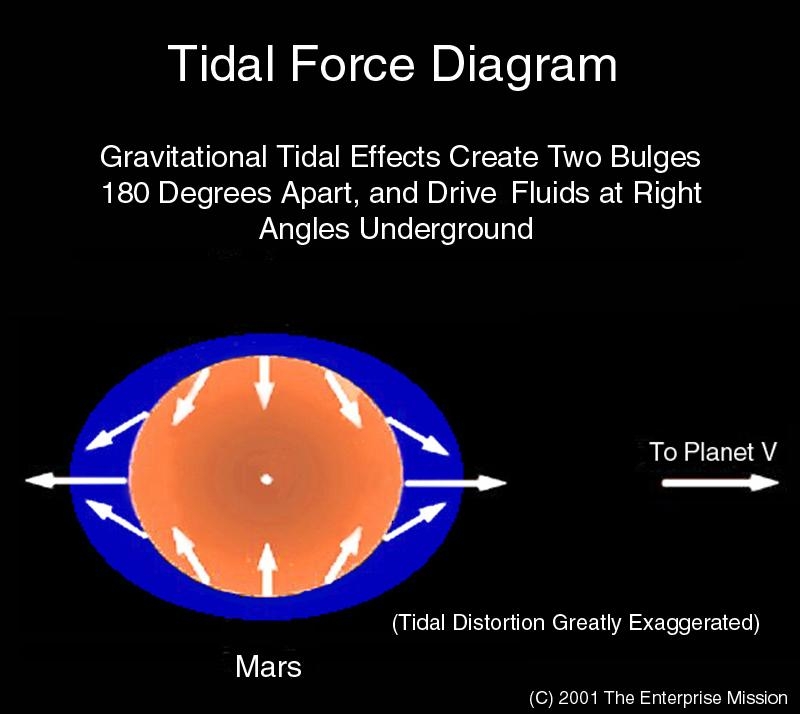
Figure 17 Water is forced into sub-crustal cavities in the ocean beds by the tidal forces exerted by Planet V at right angles to the lines of force.
This important
theoretical detail is neatly confirmed by the crucial observation that
the stain flow images are clustered only in the Tharsis region
and Arabia, exactly 180 degrees opposite.
Any water apparently residing in between these two locations
seems to have been driven underground by the proposed tidal stresses
on the planet. So deep, in fact, that it is now unable to leave any
surface indications between these two former tidal poles.
Another observation consistent with the idea that the stains reflect current water reservoirs just below the surface, relates to the line of dichotomy itself. Stains observed on Tharsis seem only to occur north of this line of demarcation. This implies that the smoother hemisphere to the north is the older geologically, as on Tharsis it possesses the majority of the subsurface water/surface stains now remaining from one of the two tidally separated oceans. If the material making up the more heavily cratered southern hemisphere is due to superimposed material on the smoother, more eroded original crust (Figure 18), then we would likely not now find much water near the surface in those regions even under the former Tharsis tidal ocean.
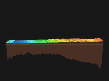
Figure 18 MOLA generated 3D topography strip showing the dramatic difference in crustal elevation between the heavily cratered southern highlands and the smoother northern lowlands. Possible water stain images appear only above the crustal line of dichotomy.
The
exception to this pattern would appear to be the location of the opposite
tidal ocean the Arabia Terra plateau, which is heavily cratered
as if from the Planet V event, but possesses the second highest number
of current water stain images (see Figure 5). Recent scans from MOLA
have shown that the crust is significantly thinner in Arabia than it
is in most of the cratered southern hemisphere,
[30]
accounting for the presence of relatively shallow
water seepages beneath this former ocean.
Additionally, researchers Brian Hynek and Roger Phillips from
Washington University in St. Louis, interpreting this new altimeter
evidence from Mars Observer, conclude that an enormous amount of surface
material was somehow excavated from the planet's western Arabia Terra
region.
[31]
We
argue that this entire region has been massively eroded," said
Hynek. "The region used to look like the rest
of the [southern] highlands, but a vertical kilometer of material
enough to fill the Gulf of Mexico has been relocated downslope and
spread out into the northern plains."
According to Hynek, the most likely erosional force of this magnitude
is flowing water. Lots of things can erode planets. Wind is very effective on long timescales.
Volcanoes, ice, and glaciers can all erode features, he said.
But on this large of a scale these are unlikely explanations.
Their puzzling observations are neatly explained by the sudden collapse of a former tidal ocean previously maintained by Planet V. When Planet V exploded, a massive wall of water would have been released in a few hours, rushing northward taking a good deal of Arabia Terra with it in the process exactly as Hynek and Phillips now conclude. This, of course, also explains the current surface presence of stain images in this region they are the exhumed underground remains of the subsurface waters from this former Arabia Ocean."
The Destruction of Planet V
We have freely
used the phrase in this paper when Planet V exploded to describe the eventual disappearance
of Planet V and the release of Mars back into a heliocentric (solar)
orbit.
In Van Flanderns original model, Planet K and Planet V disintegrated via literal explosions, leaving only a residue of smaller fragments (the asteroids and comets); most of the material from these (and previous) planetary explosions, according to Van Flandern, was completely ejected from the system by the highly energetic nature of the events themselves or subsequent encounters with Jupiter. In terms of the actual mechanism, some previously unknown physics process Van Flandern has argued, is responsible for destroying single planets well after their formation. This insistence on a heretofore unmodeled, mysterious energy release mechanism has played a major role in Van Flanderns less than enthusiastic reception by the planetary science community, in spite of the many other recent confirmations of his model. Since the evidence Van Flandern has marshaled for the after effects of this Event is far more important here than the precise destruction mechanism hes proposed, we believe a shift of emphasis could retain the best features in this instance, while avoiding the non-testable aspects of Van Flanderns original EPH model.
It
is our opinion that the eventual destruction of Planet V was occasioned
by a simple and direct (if not long overdue) collision with the other
proposed major planetary object in Van Flanderns celestial mechanics
reconstruction: Planet K. Post Apollo models for the origin of the Moon
have embraced a similar concept. As
the three leading pre-lunar landing theories for lunar origin were tested
on the returning Apollo samples and found to not fit the evidence, a
radical new theory was proposed. In
1975, Drs. William K. Hartmann and Donald R. Davis, writing in ICARUS,
suggested that the Moon was formed as a side effect of a catastrophic
glancing collision of the Earth with another major planetary object. Their idea was that a Mars-sized planetisimal
collided with the early Earth, spalling off enough lightweight crustal
material to recondense to form the Moon.
In 1984, the first planetary conference to specifically consider
all aspects of this revolutionary theory was convened, titled Origin
of the Moon.
[32]
It is our proposal that a similar event, simply delayed
by a quirk of celestial mechanics until very late in solar system history,
precipitated the destruction of two planets in the current Asteroid
Belt ~65MYA. This event, we suggest, thus liberated Mars from its temporary synchronous
orbit of Planet V to once again pursue a solitary if significantly
more elliptical than any other inner planet -- solar orbit.
Remarkably, at a June,
2001 Earth Systems Processes Global Meeting in Edinburgh, Scotland,
astrobiologist Bruce Runnegar of the University of California in Los
Angeles presented some striking independent evidence that something
major happened in the solar system ~65 million years ago.
Runnegar and his colleagues had previously identified evidence
of a 400,000-year cycle in ancient ocean sediments, indicating changes
in Earth's climate corresponding to natural fluctuations in its orbit.
To probe this cycles influence on Earth's climate over the past
100 million years, Runnegars team constructed computer models based
on known variations in planetary orbits, their proximity to the Sun
and their interactive perturbations.
In running the models, they found that the known fluctuations
of the solar system's dynamics remained constant going back to 65 million
years ago. Then, to their surprise,
the frequency of perturbations to the orbits of the inner planets suddenly
changed.
[33]
If
the orbits of Mercury, Earth and Mars were being shaken up at this time,
maybe asteroids were being shaken up too, says Runnegard.
Or, maybe they were being formed in a gargantuan collision.
Aspects
of this model echo another source of surprising information about the
solar system: cuneiform records from the earliest high civilization,
the Sumerian. Zecharia Sitchin has written extensively about the Sumerians
uncanny knowledge of possible collisional events from this earliest
period of solar system history.
[34]
With the latest discoveries of radically different
extra solar planetary systems and current theoretical efforts to understand
these systems in terms of potentially interacting planetary orbits,
the relevance of Sitchins Sumerian translations should take on new
meaning.
In our Mars tidal
model, the result of such an unimaginable collision of two massive planetary
objects (remember, at least 4-5 Earth masses each) would be almost indistinguishable
from a literal planetary explosion.
The effects of the collisional destruction of Planet V and K
on a nearby captured Mars, orbiting less than 100,000 kilometers away,
would have been almost inconceivable.
In addition to the discovery of suddenly shaky planetary orbits
at ~65 MYA, such an Event should have left a number of predictable surface
features on Mars itself other unmistakable signatures of vast destruction.
Signatures of a Catastrophe
Assuming that only the top 1% of Planet V and Ks lithospheres
survived this disruptive Event -- as accelerated chunks of various-
sized crustal debris moving outward from the site of the collision --
large amounts of much smaller materials from the exposed high temperature
mantles and cores of the respective planets would have been ejected
at high speed directly towards Mars in this Event. In looking for resulting evidence of their
impacts on Mars, we should expect to see signatures of rapid surface
heating and then freezing; catastrophic water and associated mudflows;
a major loss of atmosphere along with huge quantities of water; and
finally hemispherical cratering on Mars from a vast amount of blast
debris from Planet V.
Mars
shows all these signatures and more.
The
strongest direct evidence of a debris-filled explosion Event occurring
close to Mars, is the mysterious line of dichotomy separating the
northern and southern hemispheres at that angle of 35 degrees.
Logically, if Mars was in synchronous orbital lock with Planet
V when the explosion came, then evidence of a wave of impacts from
the destruction of the Planet should be plastered all over Mars one
side, at right angles to the incoming debris.
It is not. Instead, the line of dichotomy is aligned (~60
degrees) to the current Mars spin axis.
And the authors acknowledge that this presents some serious problems
for this entire model.
Without
the narrow orientation constraints now imposed by the Mars tidal model
presented in this paper, some previous workers have attempted to explain
away this serious geometric discrepancy by proposing a completely different
pole position for the pre-explosion Mars: an original rotational axis
almost 90 degrees to the current orientation.
Such a situation is termed polar wander, and involves the long-term
mechanical realignment of a planets spin axis (relative to surface
features) after a new mass distribution is imposed either internally
(long-term convective flow) or externally (material accreted from major
impacts).
[35]
This wander continues until a new rotational
equilibrium is established under the influence of the new mass distribution,
with a new resulting pole position.
The
nature of this new mass redistribution, which subsequently forced
Mars to assume its current pole position, was assumed in this case to
be the sudden addition of significant crustal mass from the disintegrating
Planet V. If Mars pre-explosion
spin axis had been perpendicular to this incoming wave of blast debris,
so this theory proposed, the momentum of the impacts coupled with the
unbalanced additional mass piled on the planets side, would have
initiated a polar wander scenario until Mars toppled over to reach
its current position of new rotational equilibrium, relative to its
current surface features.
Our tidal model,
and the evidence supporting it presented here, emphatically forbids
such an easy dynamical solution to this major problem. The alignment of Mars prior to Planet Vs destruction is now firmly
determined: it must have been
with the Tharsis/Arabia line aimed directly toward Planet V (Figure
6). The spin poles would then
have been at right angles to this immovable alignment.
So, the debris from the explosion should have smashed into
the planet at right angles to the current Mars Equator which
the line of dichotomy shows it clearly did not.
It has been argued
that some major debris huge ejected pieces of Planet Vs disintegrating
crust -- reached Mars first. That
these planet-busting impacts, which left the major scars known as the
Argyre and Hellas basins, literally rolled Mars over on its side
before the blast wave of smaller (but more numerous) debris arrived. This however, is not at all likely. The smaller pieces would have been accelerated
fastest, and would have arrived first
followed by the
largest pieces last. Simple
Newtons Laws:
F = MA.
So, what is our
solution?
We propose that as it was approaching Planet V toward its ultimate collision, Planet K passed close by Mars in its orbit around Planet V (Figure 19). This close encounter gravitationally interfered with the tidal lock between Mars with Planet V. In fact, it began a radical, gravitationally induced reorientation of the entire Mars spin axis relative to Planet V. This was NOT internal polar wander relative to surface features, but an entire change of the obliquity of Mars (spin axis tilt) relative to Planet V.
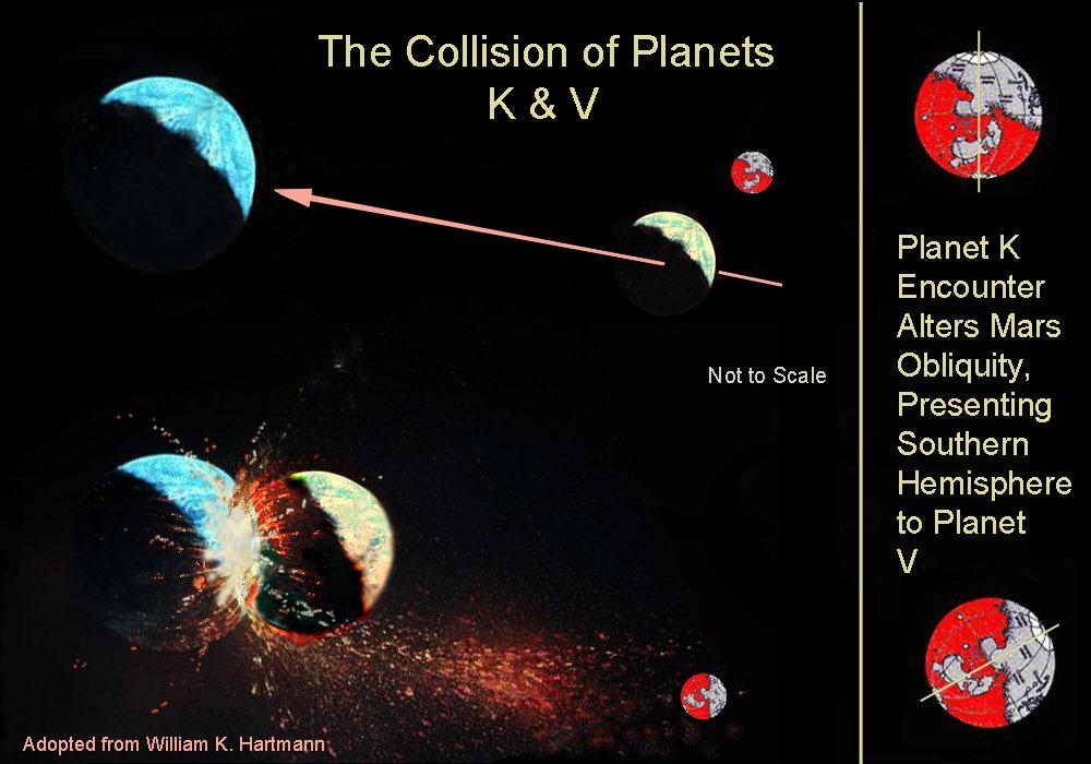
Figure 19 Proposed collision event of planets V and K. Close approach of planet K alters Mars obliquity, resulting in a debris splatter pattern 60 degrees to previous (and current) spin axis.
After initiating
this first major change in Mars orientation in perhaps several hundred
million years, Planet K continued inward toward its catastrophic rendezvous
with Planet V. This impact initiated
an almost inconceivable release of energy the equivalent of Van Flanderns
EPH explosion and the shattered fragments of the crust of both worlds,
accelerated by the enormous blast, began their spherical, outward journey
through the solar system. Some
of them, a tiny fraction of the total mass of both exploding planets,
in the space of a few hours eventually reached Mars.
But, by the time the first major wave of fragments had arrived,
Mars had tipped over by some ~60 degrees, presenting almost the entire
southern hemisphere to the explosion. Thats why the line of dichotomy is tilted
by that ~60 degrees, relative to Mars spin axis. In fact, as Mars continued to heel over and larger, slower fragments
continued to arrive, this was when the material which partially covered
Arabia Terra reached the planet. Shortly
after that, the largest, continent-sized fragment -- which created the
2300 kilometer wide, 5 kilometer deep Hellas basin, the largest on the
planet Mars impacted south of Arabia Terra (Figure 20).
[36]
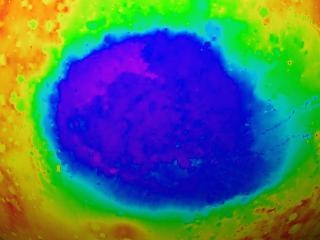
Figure 20 Hellas 2300 km impact basin
Approximately 12
hours since the collision of Planets K and V had now elapsed.
The effects on
Mars of such an unimaginable collision/explosion right next door would
not be limited to massive, visible impacts on the surface. The effects of countless megatons of smaller, accelerated mantle
and core material from Planets K and V, entering the Martian atmosphere
at hypersonic speeds, would literally superheat that atmosphere and
then blow a major fraction of it into space.
Any surface waters would literally boil from the shockwaves and
radiant heating of incoming high-velocity debris, and a major fraction
of that water would then join the atmosphere in its escape.
With the immediate loss of a significant percentage of the atmosphere,
temperatures on the surface would plummet, resulting in any remaining
liquid water quickly freezing. Shallow
underground reservoirs would remain liquid for a longer interval, before
also becoming ice.
It is a snapshot of these bi-modal, formerly flash frozen water concentrations at the moment of catastrophe the locations of the two former Martian tidal oceans -- that the current stain images now seem to be confirming.
Chemical Signatures of a Collision Event
Several current geochemical puzzles
regarding Mars are solved with the introduction of this Martian satellite
model. When Viking carried
out the first insitu surface composition measurements in 1976, one of
the puzzling results was an unusually high percentage of sulfur in the
soil. Compared to an average surface abundance on
Earth of 0.07%, Viking reported a Mars sulfur abundance of over 3% --
43 times more. Similarly,
iron on the surface of the Earth is 3.8%, while on the surface of Mars
it measures over 15%.
[37]
Models for planetary
formation generally agree that iron and a host of other heavy elements
sink to the centers of newly forming worlds to form high-temperature
cores.
[38]
Another generally agreed upon core constituent,
present to approximately 10%, is sulfur as FeS. In the awesome collision of two such massive planetary bodies, it
is inevitable that copious amounts of these high-temperature materials
would be ejected directly into space.
It is our proposal in this paper that not only did this occur,
but that Mars swept up precisely these abundant core materials; which
is why they now exhibit such unusual and misleading abundances in the
surface materials mantling the planet.
Recent Surveyor
composition data from the Thermal Emission Spectrometer (TES) has revealed
that this anomalous sulfur is in the form of sulfates, as opposed to
iron sulfide the form of the original FeS we are proposing.
It is obvious, in our model, that the original FeS falling out
of space became oxidized, turning into sulfates.
A similar fate seems to have befallen the anomalous iron that
also rained on Mars from this catastrophe.
For
Mars presents us with a greater paradox than sulfur.
We must ask a far more basic question: why is it so red? Mars redness, we now know from TES data,
[39]
results from the extensive drifts of iron oxide
strewn across the surface. A
fundamental question then becomes: if the original iron source was metallic
iron, from the exploding/colliding planets cores, where did the free
oxygen come from to eventually oxidize that iron down on Mars?
Even primordial free oxygen, capable of oxidizing iron in geological
strata termed banded-iron formations and red beds on Earth, it is
agreed, derived from one main source: growing biological activity.
[40]
In
the iron-rich, rusted sands of Mars, are we seeing striking evidence
of similar biological activity? Did
the rain of iron falling from the sky from the destruction of Planet
V encounter an atmosphere containing copious free oxygen bringing
to a tragic end a biological Garden of Eden era for the captured
Mars?
Mars Global Surveyor surface composition data indicates another major surface anomaly on Mars that supports this tidal model. Using the information from TES, Robert N. Clarke and Todd M. Hoefen, of the U.S. Geological Survey, have reported the identification of widespread abundances of olivine [(Mg, Fe)2 SiO4] on the Martian surface (Figure 21). [41] As olivine (an iron-magnesium silicate) quickly weathers into other minerals in the presence of liquid water, its surprising abundance according to all conventional Mars models would indicate that the planet has been cold and dry for the last several billion years. Its widespread presence, according to Clark, seems to effectively preclude former models of a warmer, wetter Mars.
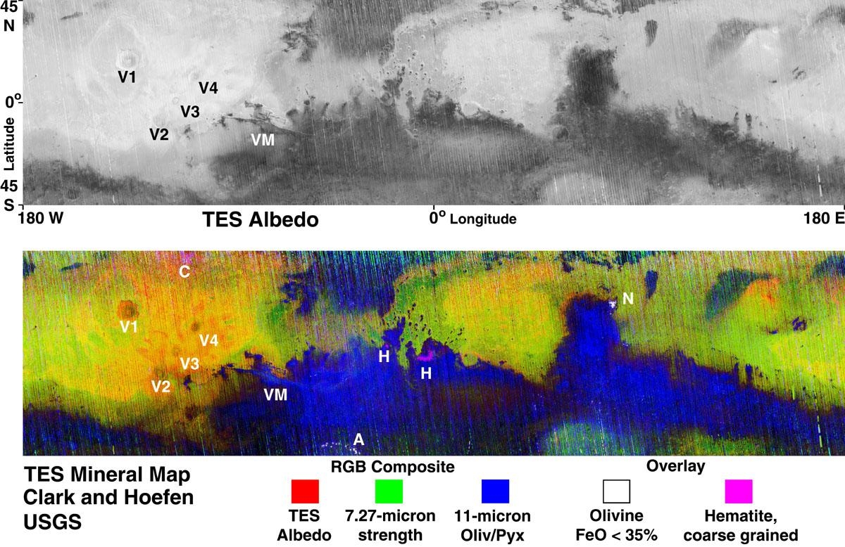
Figure 21 - Mars global Olivine distribution (Blue) (USGS).
Our
interpretation is quite different: that the source of Mars olivine
(like its anomalous iron and sulfur) is totally external -- also
coming from the destruction of Planet V, rather than from conventional
internal ancient volcanism.
Because
olivine is thought to be a major component of the mantles of the inner
rocky planets, its dispersion into space in a major planetary collision
would be inevitable. Like the anomalous presence of iron and sulfur
in the Martian surface soils (in our model, from the collisionally-exposed
planetary cores), we now propose that the unexpected global abundance
of olivine is also precisely in accord with the hypothesis presented
here: that a collision/explosion of two major Earth-type planets released
enormous quantities of mantle material directly into space.
And that Mars inevitably swept up a significant amount of this
rapidly condensed material. Because
Mars climate radically changed immediately after this Event, and its
remaining water froze, the presence of large quantities of unweathered
olivine on Mars can only be another striking signature of. Mars former
existence as a satellite of Planet V -- which (the olivine confirms)
was then catastrophically destroyed.
If our model is correct, there should be two additional observations strongly
supporting this assertion. First,
the olivine that TES detected should be primarily concentrated in the
areas defined as being from the blast wave pattern of Planet Vs destruction. Second, the current water stains should cluster
in areas with low current olivine detection.
Point number one: examination of the global
olivine distribution map from TES (Figure 21), shows that over 90% of
this important mineral is concentrated in areas south of the
line of dichotomy on Mars where impact debris from Planet V is also
concentrated. Again, olivine in this amount would normally be found in unweathered
volcanic fields newly erupted from the planetary mantle. Since the standard model for explaining Mars
heavily cratered southern hemisphere assumes a very ancient surface,
this presents a fundamental problem.
On a planet otherwise exhibiting abundant evidence of extensive
water flows and its attendant weathering of olivine, how can the current
surface distribution of this mineral support an ancient southern
hemisphere? The answer is: it cant. Thus, we take this
wide-spread olivine as strong confirmation that a) the source of this
material is new, and b) is external to Mars underlying
landscape; more precisely, that its simply accreted mantle material
from the disintegration of Planets K& V.
Point number two: by overlaying Palermos stain global distribution
with the USGS TES mineral map from Clark and Hoefen, we can easily assess
the second correlation. As one
can see (Figure 22), the water stain image clusters occupy almost
exclusively areas with little or no olivine.
This is also entirely consistent with the model weve proposed,
that these stains are evidence of current, extensive, ground-based liquid
water.
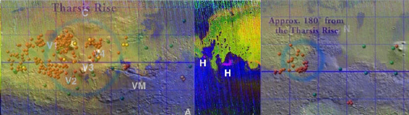
Figure 22 Water stain map superimposed over Olivine distribution map.
Further
corroborating evidence for this dramatic sequence of events comes from
additional TES data. As reported
in SCIENCE,
[42]
two
distinct surface spectral signatures have now been identified on Mars
from low-albedo regions of the planet.
Comparisons with spectra of terrestrial rock samples indicate
that the two compositions are a basaltic mix dominated by plagioclase
feldspar and clinopyroxene, and an andesitic (silicic) composition dominated
by plagioclase feldspar and volcanic glass.
The distribution of these two distinct mineral compositions is,
again, split roughly along the planetary dichotomy line.
The basaltic composition is confined to the heavily cratered
terrain in the south, and the more silicic composition is concentrated
in the northern plains.
This separation of Mars into two distinct mineralogical regimes, composed
now of two very different surface materials one considered primitive
(because the chemistry is simple), and the other complex (because
its formed by extensive weathering of lighter, differentiated crust
materials) is in fact another remarkable confirmation of the tidal
model. In the conventional geological history of Mars,
the discovery of a basaltic (primitive) volcanic rock composition
of the (below the line of dichotomy) southern hemisphere, indicates
as we have noted that this part of Mars is considerably older than
the rest of the planet. The
theory is that it in fact dates back to the earliest history of Mars,
when the first massive basaltic volcanism was forming surface crust.
In this view, the (presumed) remnants of the last heavy meteor
bombardment are also represented on this primitive southern hemisphere,
by the extensive cratering below the line of dichotomy. This overwhelmingly
crater-covered landscape, in this theory, simply confirms the idea that
this is truly ancient 3+GYA original Martian crust.
The tidal model, and its associated Planet V destruction,
takes the same data and presents a radically different reconstruction.
In our view, this bi-modal surface composition
is actually another major confirmation of the tidal model. The massive cratering and basaltic (primitive)
composition of the southern hemisphere stems directly from the same
external source that left the mysterious olivine, iron and sulfur
strewn across the planet: the primitive, infalling mass of basaltic
mantle and core materials which have covered Mars to a
depth of almost 30 kilometers from the exploding Planets K & V.
The more weathered northern plains, according to TES data, also
confirm contrary to all the conventional Mars models -- that it is
in fact the older hemisphere of Mars, and was long exposed to
the erosive and weathering effects of liquid water
if not perhaps
free oxygen.
The last major signature of Mars former existence as a tidally locked satellite of Planet V, and the sudden catastrophic change in that condition, comes from a close examination of the Tharsis bulge itself.
Roger J. Phillips, of Washington University, and several colleagues, recently published an extensive new study of this massive Martian feature. Phillips reports that the Tharsis rise is the result of 300 hundred million cubic kilometers of lava -- enough to cover Mars 2 kilometers deep, if spread evenly across the planet -- that somehow became concentrated in one place on Mars. This calculation is far greater than previous estimates from past studies. [43]
Around much of the Tharsis rise is a puzzling, low-lying area called the Tharsis trough (Figure 24). Phillips says, "Imagine that Mars is a beach and that the Tharsis mass load is your fist. As your fist pushes into the beach ball, there is a bulge created on the opposite side of the ball (the Arabia bulge), and a depression or trough surrounds your fist (the Tharsis trough)."
The authors -- in light of the tidal model presented in this paper -- have a very different interpretation of these associated features.
.
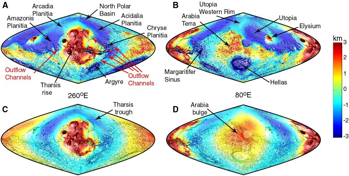
Figure 23 The Tharsis Trough (MOLA).
The authors in light of the tidal
model presented in this paper -- have a very different interpretation
of these associated features.
As
noted earlier, it is endemic to the tidal model that both the Tharsis
bulge and its 180-degree smaller counterpart, Arabia, are classic signatures
of tidally distended fluids.
The enormous bulk of Tharsis cited by Phillips in this recent
study merely demonstrates how effective the tidal forces from Planet
V truly were, in allowing such an enormous mass of mantle material to
rise above the Mars mean datum against Mars gravity some 10 km above
the surrounding terrain. This
condition is termed hydrostatic equilibrium.
It
is intrinsic to this model that when Planet Vs partially supporting
tidal forces were suddenly removed, this enormous Tharsis mass was suddenly
dependent for its continued elevation solely on existing internal forces
within Mars. The result was inevitable: over millions of
years, Tharsis began to slowly sink back toward the center of Mars,
seeking to establish a new state of hydrostatic equilibrium. The Tharsis trough around this massive concentration of material
is merely the result of an inevitable depression in the Martian crust
around this ponderous mass (Figure 23), as that crust has broken and
sunk under the enormous (now unsupported) weight of Tharsis, attempting
to come to a new equilibrium condition.
As
for the Arabia bulge on the planets other side, contrary to Phillips
assertions, its uplift had nothing to do with this partial relaxation
of Tharsis back into the mantle. To
the contrary, as previously noted Arabias original uplift was a separate
tidal signature of Mars previous close association with Planet V.
After its destruction, Arabia experienced its own partial readjustment
toward Mars center, also in direct response to the removal of the previously
partially supporting tidal forces from Planet V.
One
side effect of this inevitable sinking process, of bringing Tharsis
and (to a lesser extent) Arabia into a new condition of hydrostatic
equilibrium with Mars, was the late creation of a whole new volcanic
rise at 90 degrees to both these former uplifts.
In looking at the map (see Figures 8 and 9), it is obvious that
the Elysium uplift is the direct result of the release of compressional
forces in Mars mantle, the slow sinking of the two former tidal masses
on both sides of Mars seeking a new equilibrium. Over time, the enormous potential energy released
within the mantle from the partial downward readjustment of Tharsis
and Arabia caused a pulse of major heating inside Mars where the internal
forces balanced. The result,
90 degrees in between, was the creation of a much later, much smaller
volcanic uplift -- Elysium Mons.
Magnetic Confirmation of Catastrophe?
For
many years the question has remained: does Mars (like all the other
planets measured) possess an intrinsic magnetic field? This question
is important to geologists and biologists alike.
For, if Mars has (or had) a sizable magnetic field, then
the evolution of the planet would have been far more benign for the
development of life. Mars Surveyor, beginning in 1997, finally gave
an answer to this question: no. The
core mechanism which would support an active Martian magnetic field
generation process, like in the Earth or Jupiter, has died -- leaving
only a remnant surface field from an ancient dynamo to be detected.
But what MGS did detect of this ancient Martian field is quite bizarre:
a remarkable series of magnetic bands, stretching across a huge swath
of the southern hemisphere, a quarter of the way around the planet (see
Figure 24). These irregular
east/west stripes measure about 100 kilometers wide and are up to 2000
kilometers in length. The stripes
represent areas of Mars ancient frozen field, recorded in magnetized
strips of Martian crust, alternating in polarity North/South until
they reach the line of dichotomy, where they then mysteriously dissipate.
[44]
Two important additional facts: the bands do not
extend into the northern plains; and, they also mysteriously stop at
the locations of the huge Argyre and Hellas impact basins.
When planetologists were initially confronted with this data, they likened the magnetic striping to an analog of magnetic banding seen in sea floor spreading here on Earth, a strong signature of plate tectonics. This view was reinforced by the location of the Mars magnetic banding: exclusively in the heavily cratered southern hemisphere (Figure 24). These workers immediately equated the banding (in their model) with the process being very ancient -- dating back to the original formation of Mars basaltic crust. The main problem with this model: the Mars banding is far larger than the suggested parallels on Earth, and there seems to be no point of symmetry from which the upwelling lava spread out in both directions, unlike undersea ridges here on Earth which are creating new seafloor in this process. [45]
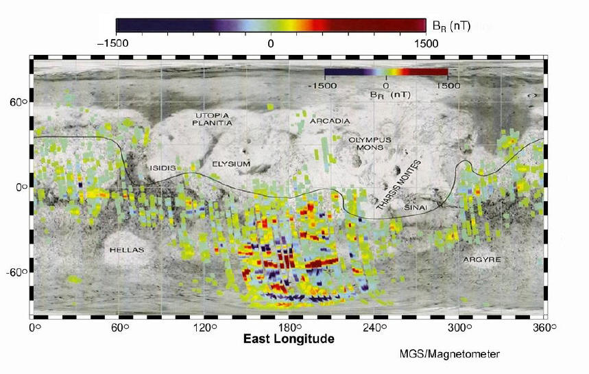
Figure 24 Mars magnetic field striping distribution. (NASA/MSSS)
We suggest a completely different origin. When the initial wave of
blast debris from K and V reached Mars, it proceeded to leave a vast
sea of molten rock across the southern hemisphere from the millions
of essentially simultaneous impacts.
The seismic effects in Mars from such an inconceivable event
can only be expressed in terms of the well-known Richter scale.
Calculations have been done expressing the conversion of the
expected impact energy of a colliding object into seismic shaking.
[46]
These calculations demonstrate that even the fall of a one kilometer object on Earth can locally create the equivalent of a 9.5 Richter scale earthquake, the largest ever measured. Imagine a rain of objects a million times greater -- ranging from a few hundred meters to several kilometers across all hitting Mars simultaneously. Even allowing for the lesser gravitational acceleration of Mars, and the lower initial velocity of debris from the near-by K & V collision when compared to Earth events, this wave of impacting debris would amount to an input of seismic energy roughly equivalent to a Richter Scale 15 Event across the entire planet.
The
closest recorded approximation of the physics of such an event may be
found during the Apollo lunar missions.
In 1969, after the Apollo 12 astronauts emplaced a seismic experiment
on the lunar surface, the ascent stage from their discarded lunar model
was deliberately impacted back on the Moon to calibrate the experiment.
According to the official NASA mission documents and press reports,
the Moon rang like a like a bell for over an hour after impact
[47]
One explanation was that the dry, upper layers
of the Moon efficiently transmitted the impact energy (equivalent to
1600 lbs of TNT) of the impacting LM, as a set of standing waves around
the Moon, first increasing and then decreasing in intensity as the energy
was reflected between two upper layers of the lunar crust.
We propose a similar phenomenon but at an incalculably greater
intensity occurred on Mars as a direct result of the barrage of impacts
that blanketed the southern hemisphere from the destruction of Planet
V.
We
suggest that the input of this much seismic energy, simultaneously across
the entire southern hemisphere of Mars, created a set of unprecedented
standing P and S waves within the crust, reverberating back and
forth between the Martian poles. In this hemisphere, literally melted from the
multiple, overlapping impacts, these resonant harmonics cooled the banded
sections first (in the rarefactions between the standing waves) -- resulting
in the existing background global magnetic field of Mars being frozen
in -- as a series of alternating bands of polarity within the heavily
iron-enriched rocks (Figure 24). (This well-known threshold, whereby
magnetic materials cooled below a certain temperature will retain a
background magnetic field, is termed the Curie point.
[48]
) As a further confirmation of our model, we
point to the anomaly of Argyre and Hellas.
The MGS magnetic survey discovered that the banding stops at
the site of these two major impact basins.
We propose a simple explanation for this important observation:
in keeping with basic Newtonian physics, which constrains these largest
fragments of Planets K&V to arrive last, it is consistent
with this model that when these massive, slowly-moving impactors arrived
and excavated their respective basins, their colossal collisional energy
destroyed the delicate standing wave conditions for preserving the
magnetic banding from the previous debris.
They also raised the local material above their Curie point again,
literally melting any cooling bands which had previously formed in these
locations. In this way, the
absence of magnetic signatures around these two major impact sites confirms
that they had to have arrived last.
We
therefore propose that the puzzling magnetic banding of alternate polarity
on Mars arose, not from any type of ancient Martian plate tectonics,
but as a direct result of the enormous seismic energy transferred to
the southern hemisphere by the countless massive impacts from the recent
(~65 MYA) destruction of Planet V.
We further submit that the complete absence of any similar phenomenon
elsewhere on Mars north of the impact line of dichotomy -- is compelling
evidence for this hypothesis. And finally, this key indication of Mars former
active magnetic field, inferred from the strength of the frozen field
magnetic bands -- approximately
1/400th Earths current surface field is more than sufficient
to have encouraged a viable Martian biological environment
in recent
times.
Another Moon?
In Van Flanderns original celestial
mechanics model for the EPH, his analysis of the orbits of long-period
comets strongly implied another, far more recent explosion event
than the one weve been discussing here.
[49]
Van Flandern proposed a second satellite
of Planet V as the cause of these new comets, which was destroyed in
a similar manner to Planet V, but after several million years. Calculations showed that after Planet V was shattered and its determining
gravitational field disappeared, Mars and this second satellite could
have gone into an orbit around each other. According to Van Flandern, such a second orbital
capture had about a fifty/fifty chance, of taking place.
[50]
That such a late
destructive event took place is well-supported by the comet orbit data
Van Flanderns analyzed. Whether
this event took place with this second moon orbiting as a satellite
of Mars is much more problematic.
It is our proposal in this paper that the logical mechanism of
destruction of such a second hypothetical satellite would have been
another world-shattering collision. Because of later interactions with Jupiter,
the primary debris of the original collision would have been diverted
into orbits which eventually crossed the orbits of all the other planets
in the solar system. This (according
to Van Flandern) is why there are so many recent impact craters on solar
system objects; they stem from the debris of this 65 MYA Event, mopped
up by subsequent collisions throughout the solar system.
As
an extension of this process, the most massive remaining fragment(s)
of Planet V would have remained near the new orbits of Mars and any
second wandering moon, but in a somewhat eccentric orbit.
In our reconstruction, consistent with the comet data indicating
a second fragmentation event, the inevitable collision of such a Planet
K/V fragment with this second moon likely took place 62 million years
after the destruction of Planets K & V. But, unlike Van Flanderns reconstruction,
we do not believe that such an event necessarily took place in the immediate
vicinity of Mars. Van Flandern
believes that Mars and the second moon had to have been orbiting each
other, primarily because the massive evidence of late water flows
on Mars and a presumed high water content for the composition of this
second moon. In our model, because of the tidal release
of vast reservoirs of Martian water after Planet V was gone (water not
known to Van Flandern when he first proposed his model), we believe
the fluvial signatures he ascribes to the destruction of this second,
Europa-type moon were all created 62 million years earlier,
in the immediate aftermath of the Planet V destruction at 65 MYA.
Effects Beyond Mars
The
catastrophic destruction of a moon or major planet either through
collision or explosion could not take place without leaving major
signatures far beyond its immediate vicinity.
One potential signature -- the peculiar orbits of the long-period
comets was the data that initially awakened Van Flanderns interest
in this subject. But there are
other indicators that now amply support the model of a former tidal
Mars, and the catastrophic destruction of its foster parent.
These
include the striking hemispherical dichotomies seen on several other
solar system objects, in particularly Iapetus, one of Saturns icy moons
(Figure 25). Iapetus orbits Saturn in 79.33 days. As the initial blast wave of high temperature,
carbon-rich debris from the destruction of Planets K&V spread out
across the solar system, it eventually swept past Iapetus. Because of the satellites slow, almost 80-day tidally locked rotation/revolution
around Saturn, the debris passing Iapetus in only a few hours -- impacted
essentially on the facing side of Iapetus resulting in one of the
most asymmetrical objects in the solar system.
[51]
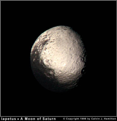
Figure 25 Saturns
moon Iapetus, pitch black on one side as if from a blast wave.
The
extraordinary events occurring at the end of the Cretaceous Period (~65MYA)
on Earth is also on this list. From
the sudden extinction of the dinosaurs and 50% of all other species,
to the world-wide layers of iridium and soot that are now evidence of
an extraterrestrial impact of unimaginable global scope, the destruction
of Planet V obviously also left its tragic mark as far away as Earth.
[52]
It is now apparent that the object which struck this
planet ~65 MYA and triggered a wave of catastrophic mass extinctions,
most likely occurred as a direct result of the impact of a large (~10
km) fragment from Planets K&V. But what of later impacts?
Several years after the Viking missions returned the first
Martian atmospheric and surface composition data, workers began using
this list of elements and isotopes to compare with meteorites found
on Earth.
[53]
In 1985, the first identification of a rare
form of meteorite (one of only 13 currently known, called SNCs) as
specifically coming from the planet Mars was published.
[54]
This identification was based on a claim of a perfect
match between trapped gasses in the SNCs with the Martian atmospheric
composition measured by the Viking Landers.
But this theory is not without its critics, among them Tom Van
Flandern.
This
highly misleading paper ["Meteorites: Evidence of Martian origins"]
is the original source of the assertion [that there are meteorites on
Earth from Mars], quoted often in the media of late
Non-meteorite-experts may be forgiven for not considering what
was not shown.
·
The log-log plot [of the gasses compared
to Vikings findings] hid the size of the discrepancies for individual
gases.
·
Gases were selectively plotted only
for cases of relative agreement.
·
No comparison plots to show how well
the same data fit gas compositions for other source bodies, or
solar system averages in general, was presented.
... carbon dioxide (CO2) is the most abundant gas on Mars by far. Yet
its relative abundance in the meteorites is but a tiny fraction
of its abundance on Mars
The
case for a Martian origin [of SNC meteorites] is really a case based
on a lack of a suitable alternative [emphasis added].
[55]
In other words, without the model of colliding/exploding Planets K&
V, the only possible origin for such anomalous meteorites --
in the minds of most researchers -- is the planet Mars. With the substantive evidence for other, destroyed planetary bodies
in this region of the solar system now implicit in the Mars tidal
model weve presented serious alternatives for the origin of currently
identified Martian meteorites present themselves.
The recent discovery of trapped salt water, as small inclusions
in some meteorites
[56]
is an obvious (if astonishing to mainstream planetologists)
confirmation of a) the Mars tidal model presented here, and b) the catastrophic
destruction of its former parent planet.
If current meteorites derive from the recent collision/explosion
of multiple Earth-massed planets in the solar system and/or escaped
moons, the water from such bodies could easily be ocean water
[as on Earth, and as also projected by one of the authors (Hoagland)
to currently exist on Jupiters moon Europa].
[57]
This water, trapped within some rare meteorite
structures, would be expected to contain salt (sodium chloride) from
run-off minerals dissolved from potential continental portions of the
former planet(s). The existence of a water-soluble salt in this meteorite
is astonishing, wrote R.N. Clayton of the University of Chicago.
[58]
For all conventional (primordial) high-temperature
models of asteroid formation, this discovery truly is impossible.
Only the trapping of Mars as a former satellite, and its release
with the disintegration of Planets K&V, contains this specific discovery
as an implicit aspect of the model.
In a further note, Carleton Moore of Arizona State University reported in
the July 2000 issue of Meteoritics & Planetary Science the discovery
of anomalously high chlorine levels (one half of
the sodium chloride of ordinary salt) in the Martian meteorites
(the SNCs) in ASUs collection, as opposed to normal levels in the asteroidal
ones. The anomalous presence of water-derived salts
has also been reported in NASAs most controversial Martian meteorite
ALH84001 center of the reported discovery of fossil bacteria in
1996. Moore and his team, in re-analyzing their meteorites,
concluded the excess chlorine could easily have resulted from saltwater
leaking in. Moore sees these
elements as potential tracers of an early Martian ocean, infused with
salt compounds much like Earths own.
[59]
This elevated presence of salts and salt compounds
in the SNCs, as compared with other meteorites, in our model simply
comes from another ocean one on Planets K or V.
Thus, the elevated presence of water-soluble salts in
SNCs is also remarkably consistent with the model weve presented.
In the same vein, when the bright comet Hale-Bopp made its brief but spectacular
visit to the inner solar system in 1997, an unusual new cometary signature
was observed (although a previous bright comet, in 1957, had also exhibited
this feature.
[60]
In addition to the usual twin tails exhibited
by comets an ion tail of molecular fragments dissociated by the sun,
and a dust tail of small particles emanating from the coma --- Hale-Bopp
displayed a remarkably third tail comprised entirely of neutral
sodium.
[61]
The discoverers were at a loss to explain this unique
feature, simply saying in their announcement
there is no obvious
explanation at this moment of how the observed sodium tail is formed.
One of the authors (Hoagland) immediately realized that this
signature, while extremely puzzling to most astronomers and planetologists,
was totally consistent with the EPH hypothesis, and could easily be
explained by an unseen parent molecule within the new tail: sodium chloride.
In other words, if Hale-Bopp was another fragment of the disrupted
planet/moon that Van Flandern initially pointed out over twenty years
ago, then the discovery of sodium strongly implied that this comet parent
body also had an ocean and Hale-Bopp was simply another fragment
of that planet. He promptly informed Van Flandern of his hypothesis.
[62]
A New Mars Timeline
One
of the serendipitous features of this model is that it now allows an
independent assessment of the relative ages of various features and
phenomenon on Mars. All previous efforts to date surface features have
had to rely on relative ages, based on crater counts, normalized to
cratering statistics and radiometric ages from the Moon.
[63]
The tidal model provides the first truly independent
means of calibrating, from a radically different perspective, the geological
history of Mars, if not other bodies in the solar system (see below).
Thus,
a new Mars chronology can now be tentatively proposed.
It is divided into three main periods: the time from solar system
formation to Mars capture by Planet V; the period of Mars existence
as a tidally-locked satellite of Planet V; and the interval post-Planet
Vs destruction to the Present.
Period I -- The earliest era of Mars history
Period I in our proposed new timescale -- remains the most uncertain
and ambiguous. In terms of the
model presented in this paper, one key reason is the presence of widespread
cratering due to the nearby explosion/collision of Planets K and V. This pattern of hemispherically devastating
impacts, coupled with the massive fluvial changes to the northern plains
that immediately followed, have all but eliminated records of earlier
Mars features from which reliable reconstruction of its history prior
to capture would be possible. The
nature of the collisional/explosive Planets K&V Event also effectively
destroyed the ability to use relative cratering as any reliable estimate
of age, on Mars (and many other satellites and planets).
As previously noted, debris from this incalculable planetary
catastrophe would not only have bombarded Mars, but also would have
spread throughout the solar system, irrevocably changing cratering statistics
and any crater-based age determinations on a host of other worlds.
Despite this major
obstacle, there do seem to be some remaining clues to dating ancient
Martian surface features. Recent
publication of MGS evidence of deep and widespread sedimentary layering
indicates a long period of warm, wet climate.
[64]
The presence in some areas of over 1000 evenly
spaced rock layers (presumably from standing water deposition) also
implies that these sedimentary deposits were controlled by cyclic climatological
events. And this, in one model,
then implies some kind of ancient, regular, polar obliquity shifts and
resulting periodic increases in atmospheric density, from changing solar
insolation of the Martian poles.
[65]
Since this kind
of cyclic obliquity shifting would be prohibited after Mars
capture as a tidally locked satellite, it is proposed here that these
conditions only could have occurred when Mars was freely orbiting the
sun as an isolated world. This
implies that Mars enjoyed a considerable period of warm, wet climate
early in solar system history, before its capture by Planet
V, and before the internal radioactive energy sources of Mars died.
In this new chronology, Mars long primordial period of isolated,
heliocentric existence -- Period I ended with the multi-body capture
of Mars by Planet V.
Period II -- In this chronology, Period II dates
from the capture event itself, to the destruction of Planet V. Surface evidence of this major phase of Mars
geological evolution includes the beginnings of radial crustal fracturing
around the Tharsis uplift; the beginnings of and rapid tidal enlargement
of Valles Marineris from one of these equatorial rifts; the despinning
of the planet until a tidal lock of ~24 hours was achieved; the beginnings
of the lesser 180-degree Arabia Terra uplift, opposite Tharsis, as a
direct consequence of the establishment of tidal lock; and the eruption
of vast quantities of N02, CO2 and H2O into the Martian atmosphere as
a direct result of the accelerated uplift of the tidally-distended Tharsis.
A significant increase in water availability, warming temperatures
occasioned by an increased greenhouse process, and bi-modal pooling
of this water into two stable east/west oceans, would have marked
what might be termed this Garden of Eden phase of Martian evolution.
If Planet V possessed
one or more additional moons, as Van Flandern has proposed, their location
in the same system as the tidally captured Mars, would have occasioned
an internal Martian heating similar (though less intense) to that currently
seen in the Io/Europa situation.
[66]
Thus, for as long as Mars was a satellite of Planet
V, internal energy from a tidally disturbed orbital condition, in addition
to its own dying reserves of radioactive elements, would have kept its
core alive, its magnetic field at full strength, and its atmosphere
constantly replenished. This
idyllic planetary situation Period II -- would have ended abruptly
some 65 MYA, in the collision of Planets K &V.
Period III The last phase of Martian history
would have begun with the destruction of Planet V and the release of
Mars back into a solar orbit. With
the sudden relaxation of its previous tidal lock from Planet V, all
the waters collected in Mars two bi-modal oceans would have rushed
toward the lowest areas again mainly the northern plains.
This unprecedented tsunami situation not only would have scoured
vast portions of the planets crust from Tharsis and Arabia and relocated
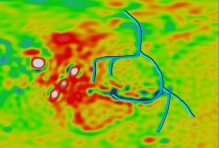
Figure
26 Outflow water channels beneath and north of Valles Marineris (MOLA)
These previous
sedimentary layers as vast mudflows across the north, the rush of waters
would have carved enormous
new outflow channels in that crust away from Tharsis and Arabia
exactly as we see.
As they plunged down the Valles Marineris system and headed north,
some of these now catastrophically released waters would have buried
older outflow channels, from the earlier phases of Valles Marineris
creation (Figure 26), under kilometers of additional sediments -- also
confirmed by the new MOLA observations.
[67]
Recent MGS observations have uncovered additional striking evidence supporting this catastrophic collapse of the former Tharsis ocean, this time northwest of Arsia Mons. Writing in the June 2001 issue of the Journal of Geophysical Research, [68] University of Arizona researcher James Dohm has billed his teams new findings as the largest flood channels in the solar system, caused by catastrophic floods of enormous magnitude some 50,000 times the flow rate of the Amazon. Located southwest of Olympus Mons (Figure 27), the newly-discovered channels are 10 times the size of Kasei Valles, the largest previously known outflow channel system on Mars. Measuring as wide as 200 kilometers, in our view only
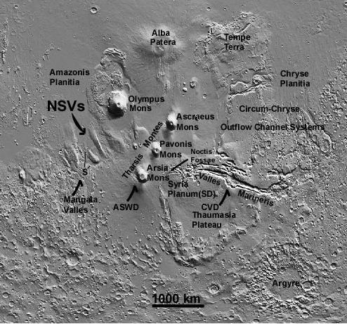
Figure 27 New flood channels on Tharsis (NVS) -- 10 times larger than any previously discovered, draining northwest.
Strikingly consistent with this model is the bi-modal distribution of all the Martian outflow channels. If the oceans weve projected were bi-modally distributed, as we now state categorically, then the outflow channels emptying those oceans when the tidal lock collapsed would also be expected to have a bi-modal distribution in the geologic record. Again, this is exactly what we see. Examination of the channel distribution maps from MGS (Figure 28) reveals that catastrophic outflow channels draining the two potential tidal oceans are unquestionably also bi-modally distributed -- around the periphery of both the Tharsis and Arabia regions, exactly as the tidal model would predict.
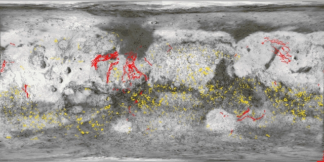
Figure 28 Image map showing bi-modal outflow channel distribution from Tharsis and Arabia ocean beds.
Apart from
the immediate (and catastrophic) relocation of Mars oceans, the slow
geological relaxation of Tharsis (and to a lesser extent Arabia) back
into the mantle after their partial tidal support was suddenly removed,
would have begun in Period III as well.
This would have created over the following millennia an inevitable
downward warpage of the crust around this massive, now unsupported uplift,
called the Tharsis trough (Figure 23).
This inevitable settling would have also triggered additional
volcanic activity both in those regions, and at 90 degrees. The latter we have now identified with the late creation of Elysium
Mons.
The
catastrophic arrival on Mars, a few hours after the Planets K&V
collision, of the first debris wave, is marked by the peculiar line
of dichotomy of shoulder-to-shoulder impact cratering that has so
puzzled planetary geologists since 1971.
These first impacts would have begun a long period of Mars continually
mopping up material left from the catastrophe near its resultant solar
orbit; estimates for this interval depend on how rapidly the huge quantity
of dust and larger crustal fragments would have either collided with
Jupiter (or other solar system planets), or would have been completely
ejected from the solar system by encounters with these bodies.
Those estimates range from a few million to perhaps 100 million
years.
[69]
Because
of this vast orbital reservoir of condensed core and mantle materials
from the Planets K&V collision, Mars would have continuously swept
up new supplies of olivine and iron-rich sulfur compounds from space
for millions of years. This process would have continually replaced
previously fallen materials weathered from surface exposure to liquid
water stemming from irregular periods of Martian volcanism, triggered
by the continuing slow collapse of Tharsis and Arabia. In this way, Mars surface history after the collision ~ 65 MYA
the beginning of Period III -- would have been a complex tale of episodic
warm, wet periods in which these primitive materials could be destroyed,
followed by cold and arid intervals in which they could once again accumulate. This episodic environment likely has extended
to the Present, triggered by this residual internal volcanism from the
continued settling of Tharsis, as well as major obliquity shifts and
their periodic warming and release of current polar reservoirs of C02
and H2O.
In our model, one direct consequence of this accreted, sulfur-rich
surface environment is the mysterious stains themselves. Appearing initially as extremely dark, flow-like
features on sloped surfaces, it is our proposal that stains are created
in Period III by underground liquid water, wetting surface sulfur-rich
materials. On the current sands
of Mars, composed of iron oxides and trace sulfur compounds, this would
initially produce sulfuric acid.
The acid would then reduce the iron-sulfur mixtures to an extremely
stable, dark black compound -- ferrous sulfide (FeS) -- which would
remain visible for years after this initial wetting.
[70]
Eventually, this black iron sulfide stain
would be converted back to reddish iron oxides, via the simple process
of oxidation (Figure 29). This
would come from the trace amounts of free oxygen continuously liberated
from Mars predominantly carbon dioxide atmosphere by solar ultraviolet
radiation.
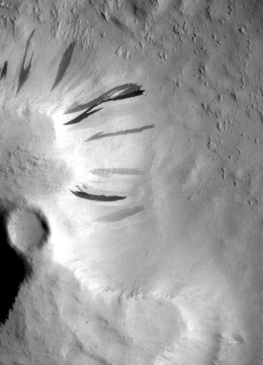
Figure 29 Dark (fresh) flows alongside lighter faded (older, oxidized) flows (USGS).
Another
validation of the tidal model may lie in the recently published work
of Kuzmin R.O. and E.V. Zabalueva Vernadsky.
In June, 2000 the two geochemists from the Institute of Geochemistry
and Analytical Chemistry, Russian Academy of Sciences, presented a paper
at NASAs 31st Lunar and Planetary Science Conference on the possibility
of liquid water on the current Martian surface.
They proposed that the presence of water-soluble salts in the
Martian regolith should influence the melting temperature of any ice
currently trapped in the upper layers of this icy, porous soil.
In the presently observed climate of Mars, such icy soil conditions
(they contend) would be expected only above 40-45 degrees North and
South (the ice, in this model, long having evaporated closer to the
Equator, in the billions-of-years history of Mars).
In the Russians calculations, the salts presence even in this
high-latitude ice-containing-soil could produce a liquid water phase
(seasonally) in a broad range of negative temperatures.
[71]
In
the tidal model, the last major source of liquid water flowed across
Mars only 65MYA -- not billions.
Therefore, groundwater would not have had sufficient time to
sublimate from the current Martian soil in regions close to the Equator.
In these equatorial regions, according to our model, now lie
the 180-degree seabeds of two former tidally-locked oceans, whose underlying
sediments would be expected to contain a very high percentage of exactly
these essential water-soluble salts needed to keep subsurface
water liquid under current Martian temperatures.
Thus,
the equatorial location of the stains (30 degrees plus or minus),
and their clear bi-modal 180-degree distribution, also strongly suggest
supported by the Russians calculations -- that stains do in fact
represent current aquifers of liquid, briny water from those
former twin Mars oceans.
It
is now undisputed that the catastrophic events which brought the Cretaceous
to a close ~65 million years ago, and resulted in the elimination of
the dinosaurs, also made it possible for mammals to eventually overrun
the Earth. And, some 62 million years later at the time
of the postulated collision/explosion of the 2nd moon of
Planet V, which (according to Van Flandern) resulted in comets like
Hale-Bopp -- one of those lines of mammals was just beginning to assume
eventual domination of the Earth the primates that would one day lead
to us.
These
events, we now believe, were inexorably set in motion by the destruction
of Planets K&V.
But
what of Mars itself? How long
did Mars spend as a satellite of Planet V in Period II -- before the
latter was destroyed? Was there time enough for life to actually
originate upon the planet, and if so, when in Period I, before
its capture -- or in Period II, sometime after?
If life did evolve on Mars, what can the tidal theory tell us
now about its subsequent development?
Are there any clues contained in the Martian tidal model which
could reveal if and when a biological capture clock for Mars was ever
started?
As stated earlier, we now know from MGS of the existence of massive, regular sedimentary layers across major sections of the planet. From these we can logically infer that Mars experienced a protracted period of systematic climatological change, most likely in response to cyclic alterations in its spin axis obliquity which laid down sediments in response to these repeating environmental cycles. [72] Clearly, this period refers to Mars orbiting the sun as a single planet -- as such significant obliquity excursions, according to the work of Lasker et al. (1993) strongly indicate that major obliquity excursions would have become impossible during Mars tenure as a tidally captured satellite. [73]
Calculations
of Mars current isolated obliquity shifts by Wisdom et al. (1995)
[74]
reveal chaotic excursions up to 60 degrees, and periods
on the order of 3-5 million years.
These would inevitably result in drastic changes in Martian atmospheric
density and temperature, as polar ices melted and refroze thus easily
producing the extensive sedimentary deposition layers MGS has now discovered.
[75]
Taking one MGS observation of a thousand individual
layers, and multiplying by the amount of time in each potential long-term
cycle (~3-5 million years), we arrive at one estimate of the span of
time represented by this pre-capture phase of Martian evolution: several
billion years. This, in effect, is equal to the ~ 5 billion
years since the formation of the solar system.
[76]
From this we can now estimate that the time
Mars spent as an isolated planet, before capture in other words,
the length of Period I -- was probably most of solar system history.
So,
when did Mars capture occur?
Based
on extensive new calculations published in recent years, it appears
that chaotic instability of the solar system orbital dynamics can
set in even after several billion years.
[77]
These calculations, however, have been performed
without consideration of two former missing planets (this model).
It is therefore likely that our solar systems stability would
be even more chaotic with their addition to the model particularly,
if (as we and Van Flandern propose) they once inhabited the current
region between Jupiter and Mars. This
is due to Jupiters disproportionate effect (from its excessive mass)
on all long-term stability considerations.
If
basic solar system physics is now questionable, even after billions
of years of apparent orbital stability, then it is also theoretically
possible for the rare planetary event weve proposed in this paper
to have occurred: the close encounter of Planet V with Mars, with the
subsequent ejection of another satellite -- required to remove sufficient
energy for capture. Which again raises the crucial question: when did this occur?
The
capture of Mars by Planet V -- through the mechanism of the ejection
of another satellite -- presents a possible independent means of dating
this seminal event. Such an ejected satellite initially would have
assumed its own moderately eccentric orbit of the sun resulting in
relatively rapid resonance encounters with either Jupiter or Earth. These close approaches, especially with Jupiter,
would have radically altered its initial heliocentric orbit, resulting
either in eventual complete ejection from the solar system or eventual
catastrophic impact with another planet.
It
is our tentative proposal here that such an impact did occur
-- with Venus as the target. Because these two events are linked the Mars
exchange of a satellite with Planet V and its eventual Venus impact
this sequence of events may in fact allow a date as to when
the capture of the planet Mars by Planet V occurred.
Venus
is a unique planet. Although
often described (because of size and composition) as a sister planet
to the Earth, in fact the two planets could not be more different.
From its atmospheric composition (~ 97% CO2) to its impenetrable
clouds of sulfuric acid (more anomalous surface sulfur
), to
its surface temperature (~900 degrees F.), to the pressure at the base
of the atmosphere itself (92 times the Earths), Venus current environment
is as opposite from the environments of Earth and Mars as one could
possible imagine. And, unlike the rotational periods of Earth
and Mars and their direction of rotation, Venus spins in the opposite
direction and takes 243.01 days to make one complete rotation.
[78]
Magellan
spacecraft radar data from its 1990-1994 survey of the planet revealed
a surprising geological discovery: some catastrophic event appeared
to have completely erased the normal range of impact craters
expected from Venus earliest eons.
The planet appeared, instead, to have been completely resurfaced
in a geologically brief period via a violent paroxysm of planet-wide
volcanism. The provisional dating
of this event: ~500 MYA.
[79]
It
is our proposal in this paper that these three phenomena the
cataclysmic global melting of Venus; the reversal and slowing of its
spin; and the capture of Mars by Planet V -- are the result of the same
causal sequence of events: the ejection of a Planet V satellite at the
same time Mars was captured, and the ultimate collision a few million
years later of that massive moon with the second planet from the sun.
This collision not only radically changed the orientation
of Venus spin axis to its current retrograde rotation, but the
energy of the event essentially melted the entire Venusian surface.
The extremely puzzling anomalous sulfur abundance seen on Venus
(as well as equally disturbing quantities of argon-40, and even chlorine
in the atmosphere perhaps a signature of a former Venusian ocean?)
[80]
is thus a direct result, in this model, of the impact
of a major silicate satellite from planet V -- propelled into
Venus a few million years after the exchange of Mars at the inner edge
of the (eventual) location of the Asteroid Belt.
This
causal chain, if we are right, thus dates Mars capture to ~500 MYA.
Remarkably,
the major biological event of terrestrial evolution was occurring
coincident with these phenomena: the sudden appearance (in less
than ~40 million years) of all the current advanced life forms
on this planet, called the Cambrian Explosion.
[81]
This was followed by ~500 million years of
subsequent evolution of those life forms, ultimately resulting in the
human species.
If
this reconstructed timeline is correct, then the extent of Period II
on Mars a warm, wet capture interval, fed by volcanic activity stimulated
by Mars tidal situation as a satellite of Planet V -- was essentially
the same as that for the appearance and development of advanced
life on Earth. This timeline now has profound implications
for the independent evolution of intrinsic Martian life.
From
the evidence we have assembled, we now know that that large oceans existed
during Period II on Mars (otherwise, there would be no vast flow channels
when their tidal lock was suddenly released); that an atmosphere dense
enough to permit a greenhouse effect to keep that water liquid also
had to exist (otherwise, there would have been no liquid water in
such vast amounts); and that such an atmosphere had to have contained
(at least toward the end) abundant amounts of free oxygen (otherwise,
the iron currently dispersed across the Martian surface would not
be in its highly oxidized condition).
These observations all parallel the simultaneous development
of an equivalent environment suitable for the evolution of advanced
life forms on Earth: time, temperature, liquid oceans, and an oxygen-rich
atmosphere.
It
is thus our tentative conclusion, based on the model presented here,
that the tidal epoch of Mars Period II -- may have led directly to
a separate, spectacular evolution of indigenous Martian organisms. In fact, there is nothing in this data to preclude the ultimate
appearance of intelligence itself.
We
only have to be willing to seriously look.
Predictions
The Mars
tidal model weve presented offers a host of future, short and long-term
observations by which to judge the full potential of the theory.
In October, 2001, NASAs next unmanned Mars mission 2001:
Mars Odyssey arrives. By December,
it will have been aerobraked into its final, polar orbit and begun a
set of unprecedented surface observations.
[82]
Some of these will be directly related to the
viability of the Martian tidal model weve presented.
Odyssey
carries three new scientific instruments to Mars: THEMIS, a combined
visual/infrared camera; GRS, a gamma ray spectrometer; and MARIE, the
Mars Radiation Environment Experiment.
[83]
GRS is an instrument designed to detect gamma
ray emission and neutrons via cosmic ray-excited stimulation from 20
primary elements including silicon, oxygen, iron, magnesium, potassium,
aluminum, calcium, sulfur, and carbon.
It
is this GRS instrument which will furnish the first definitive
test of the Mars tidal model presented in this paper.
One of the elements
GRS will detect is hydrogen. Hydrogen
makes up two thirds of every water molecule. Thus, Odyssey will map for the first time (to
a depth of approximately one meter) the global distribution of hydrogen
on Mars, from which a global distribution of all subsurface ice and/or
liquid water will be inferred.
[84]
The Mars tidal
model specifically predicts, based on the currently observed bi-modal
stain distribution in the MOC images, that Odysseys GRS will confirm
a superimposed bi-modal distribution of subsurface hydrogen over
Tharsis and Arabia on Mars. From
this, a similar bi-modal distribution of ice and water on the planet
will be inferred. Only the tidal model can properly account for
this unexpected (to all other Mars models) expected global distribution.
But,
the Odyssey observations have the potential to confirm a good deal more.
That Planet V had
to be destroyed, thus releasing Mars from its previous tidal lock configuration,
is a given of this model. But,
if the destruction of Planet V and the release of Mars was not via
a collision of the two major planetary bodies (K&V), then the only
viable alternative is a genuine explosion.
One critical test
of this hypothesis will present itself via additional impending Mars
Odyssey/GRS observations of Mars. If
a major new energy source exists, based on a revolutionary physics capable
of literally destroying worlds, then one side effect of this should
have been the creation of a series of highly radioactive short-lived
elements in the wake of the Planet V Event.
It is strongly implied, based on the calculated energies required
to explode a planet that such a source would of necessity involve
nuclear level effects in which case the associated isotopes
might well mimic those found in similar catastrophic stellar detonations.
[85]
Because of the relatively recent time frame
for the proposed destruction of Planet V (~65 MYA), several elements
and isotopes from such a massive, anomalous nucleosynthesis in the vicinity
of Mars if it took place -- should still exist.
These may include the isotopes aluminum 26, lead 107, iodine
129, plutonium 244 and samarium 146.
With half-lives
ranging from a few hundred thousand to 150 million years, Odysseys
GRS should be able to detect gamma ray emission direct from some of
these primary anomalous isotopes, if they are present on Mars in significant
amounts. Other direct decay signatures would include
neutrons, as well as electrons and high-energy helium nuclei. The second Odyssey radiation instrument -- MARIE
should be extremely valuable in corroborating the latter anomalous
high-energy phenomenon currently emanating from Mars surface, if
they are in fact present.
The global distribution
of such radioactive isotopes (or their daughter products) should also,
in the model, conform to the observed TES data on anomalous mineralogical
distributions: divided again by the line of dichotomy. If present, most radioactives (or their products)
from the Planet V Event should still be found covering the southern
hemisphere consistent with an explosion, in this variation of our
model. Measurement of the remaining isotopic distribution,
compared to daughter products, should also unequivocally determine the
date of this Event.
Positive detection
of such short-lived radioactive elements on Mars would raise the stakes
enormously. For, not only would
the specific tidal model detailed here be resoundingly confirmed, but
a clarification of precisely how Mars former parent planet
was destroyed via a new physics, with all its attendant implications
-- would finally be forthcoming.
[86]
Verification of
longer term predictions of this model depend on more aggressive manned
and unmanned Mars missions. Example:
insitu measurement of the still occurring slow collapse of Tharsis back
into the mantle, from a network of seismic stations placed at strategic
points across the surface, should confirm the recent date of this
event -- ~65 MYA.
The tidal model
also contains a cautionary tale for future missions and investigations. In the current search for Mars elusive water
reservoirs, already some investigators (Malin et al. 1999) based
on a few high-resolution MGS imaging of very selected regions of the
northern plains
[87]
have rejected the idea of ancient oceans.
The absence of wide-spread, long-term oceanic features along
the margins of the northern plains for instance, fluvial-eroded scarps
-- argues in their presentations that Mars never supported long-term,
liquid, wind agitated waters on those plains.
And, in the current Martian models, if Mars ever had significant
amounts of standing water (oceans), they would have had to
occupy those currently-observed (from MOLA), low-lying northern plains.
But this is precisely
opposite what the tidal model argues: that Mars long-term oceans were
not centered around these current low-lying northern areas --
but around Tharsis and Arabia, with a vast gap of dry land (including
portions of the northern plains) between.
Only when the tidal lock with Planet V was broken, do we contend
that a vast amount of water rushed toward these low lying northern Martian
regions. But, such waters would also have quickly evaporated
and/or frozen leaving no time to etch classic oceanic signatures
across those plains.
The warning is
quite clear: without the correct Mars model, future missions and investigations
run the serious risk of looking in the wrong locations for the wrong
surface features to test the wrong geologic models.
Likewise, an aggressive
effort to locate fossils and/or evidence of former intelligence on Mars
must focus on the correct regions in this model. Such investigations, if properly conducted,
should ultimately lead to a confirmation of our now ~500 MYA timeline
for Mars parallel biological development with Earth the discovery
of a variety of truly advanced indigenous fossils (some of them quite
large), and/or even artifacts -- only possible if the tidal model
is substantially correct.
Conclusions
Richard Feynman
was once quoted as saying You know youre on the right track with a
new idea, if you put in fifteen cents and get two dollars back.
The
Mars tidal satellite model weve presented here is just such a two
dollar idea. It for the first time accounts for a number
of baffling, enduring mysteries about the Red Planet, while at the same
time remaining consistent with each new observation -- such as the recent
equatorially constrained, bi-polar dark stain phenomena, and MGS observations
of recent (<100,000 year) ice deposits near the Martian surface.
[88]
Previously
enigmatic Martian surface features are now elegantly and simply explained
by the significant tidal forces to be experienced in such a captured
orbit. These include a unique tidal erosion mechanism
for the largest canyon in the solar system Valles Marineris; the presence
of two antipodal bulges in the mantle and crust of Mars Tharsis
and Arabia raised by these major tidal forces over time; and the otherwise
inexplicable bi-modal distribution of current fluvial signatures known
as stains, as the fossil remnants of two former bi-modal tidal oceans.
The
Mars tidal model also accounts for the presence of vast surface and
deep, ancient water channels flowing northward from Valles Marineris,
and now Tharsis; the vertical scarp encircling Olympus Mons; the otherwise
inexplicable height and volume of the Tharsis volcanic uplift itself;
the location of the Arabia and Elysium uplifts (at 180 and 90 degrees,
respectively), from Tharsis; the formation of the Tharsis trench;
the extreme difference in crustal thickness between the hemispheres
above and below the line of dichotomy; the dramatic difference in
cratering patterns between these same two hemispheres; and the sudden
fluvial excavation of massive amounts of material from the Arabia Terra
rise.
It
also accounts for the otherwise inexplicable presence of high levels
of iron, iron oxides, sulfur and olivine on Mars all major signatures
of some kind of external collision/explosion event recently
in solar system history.
The
authors fully acknowledge that certain secondary aspects of the tidal
model may not be testable as yet. For
instance, it may not be possible to precisely determine what precipitated
the destruction of Planet V. Two
possibilities have been suggested here: either, a devastating collision
with another major object also formed in this general location of the
early solar system; or, the outright explosion, via a literal new physics,
of Planet V. Either mechanism results in the return of Mars to a free orbit of
the sun circa 65MYA, as mandated by this model, and leaves vital surface
clues (for follow-on missions, such as Mars Odyssey) as to this crucial
sequence of events.
However,
there is sufficient evidence now consistent with this model to strongly
infer the prior existence of a Planet V.
This is based on the clear signatures of its effects now visible
in the topography and geology of Mars, as well as other bodies in the
solar system. The lack of a currently verifiable mechanism
for Planet Vs destruction in no way diminishes the wide-ranging implications
of the striking evidence of its demise, nor the quiet surface testimony
of its profound effect upon the body we call Mars.
Finally,
there is significant evidence that Mars environment -- as a tidally
locked satellite for ~500 million years -- created conditions astonishingly
favorable to the evolution of advanced biology upon the planet.
Recent rediscovery of decades-old Viking data, indicating the
presence of microbes in the soil exhibiting a 24.66-hour Martian circadian
rhythm, leave wide upon the possibility of much higher evolution not
yet officially discovered. This includes the now distinct possibility,
based on the eerie parallel of Mars reconstructed 500 MYA of evolution
with the Earths, of even former intelligent inhabitants.
It is the opinion of the authors that the evidence of Mars as a tidal locked satellite is now sufficiently compelling to begin a major reassessment of our current view of Mars.
Acknowledgements
The authors would like to acknowledge the following groups and individuals for their invaluable contributions to this research:
The
Enterprise Mission Membership, for their continued invaluable support
of this research.
Ron Nicks, for important discussions of the concept.
And Jill England and Effrain Palermo, for the vital statistical analysis
on which the bi-modal "stain" model is based.
[1]
Recent
Results From the Viking Labeled Release Experiment on Mars Gilbert
V. Levin and Patricia Ann Straat, Journal
Of Geophysical Research Vol. 82, No. 28 September 30, 1977
[2]
Nussinov, M.D., Chernyak, Y.B. &
Etinger, J.L., Nature 274, 859-861 (1978).
[3]
Gilbert V. Levin and Ron L. Levin, Liquid water and life on Mars,
Proceedings
of SPIE - The International Society for Optical Engineering, July
20 1998, San Diego, California
[4]
Mars Pathfinder Mission Status, Jet
Propulsion Laboratory, NASA, daily website reports, July 9 Aug.
1, 1997
[7]
Internal Structure and Early Thermal Evolution of Mars from Mars Global Surveyor, Zuber, M. et al., SCIENCE,
March 10, 2000, Vol. 287, #5459, 1788-1793.
[8]
T. Van Flandern (1978), A former asteroidal planet as the origin of
comets, Icarus
36, 51-74.
[9]
T. Van Flandern (1993; 2nd
edition 1999), Dark Matter, Missing Planets and New Comets,
North Atlantic Books, Berkeley, 215-236; 178.
[10]
Hancock, Graham, The
Mars Mystery - The Secret
Connection Between Earth and the Red Planet, Crown Books, ISBN
0-609-60086-9
[11]
Donald W. Patten and Samuel L. Windsor,
The Scars of Mars,
[12]
Philosophical Transactions of the
Royal Society of London Series A, volume 313 (no. 1524), 5-18 (1984)
[13]
NASA Activities Dec. 1980, vol. 11,
number 12
[14]
Evidence
for Recent Groundwater Seepage and Surface Runoff on Mars, Michael
C. Malin and Kenneth S. Edgett. Science
[16]
Hoagland, R.C., Bara, M.H., Enterprise Mission Investigators
Confirm Existence of Present Day Water on Mars, July 18th, 2000
[17]
A
study of Mars Global Surveyor (MGS) Mars Orbital Camera (MOC) Images
Showing Probable Water Seepages. Are They Dust Slides as NASA Claims
or Proof of Water on Mars? Efrain Pallermo, Jill England and
Harry Moore, https://www.users.qwest.net/~vtwild/webpage/SeepsPaper.pdf
[18] Edgett, K. S., M. C. Malin, R. J. Sullivan, P. Thomas, and J. Veverka, Dynamic Mars: New dark slope streaks observed on annual and decadal time scales, Lunar Planet. Sci. XXXI, Abstract No. 1058, Lunar and Planetary Institute, Houston, Texas, March 2000. (poster presentation)
[20]
The
Race to Epsilon Eridani, Schilling, G., Sky and Telescope, June
2001
[23]
Woolfson, M., Mon. Not. R. Astron.
Soc. 304, 195-198 (1999); The
satellites of Neptune and the origin of Pluto, R.S. Harrington and
T.C. Van Flandern. Icarus 39, 131-136 (1979)
[24]
The Impact origin of the Moon,
by Roberto Bugiolacchi.
https://geowords.com/histbooknetscape/l17.htm
[27]
Wu, S. S. C.;
Garcia, P. A.;
Jordan, R.;
Schafer, F. J.;
Skiff, B. A.
Topography of the shield volcano,
Olympus Mons on Mars - Nature (ISSN 0028-0836), vol. 309, May
31, 1984, p. 432-435
[29]
The Snows of Olympus, Clarke A.
C., W. W. Norton & Co., New York (1995)
[30]
Zuber, et.-al, Internal Structure and Early Thermal
Evolution of Mars from Mars Global Surveyor Topography and Gravity Science Mar 10 2000: 1788-1793
[36]
Donald W. Patten and Samuel L. Windsor,
The Scars of Mars, pp. 19-21
[37]
The
Physical and Chemical Properties and Resource Potentials of Martian
Surface Soils, C. Stoker et al., in J. Lewis, M, Mathews, and
M. Guerreri, eds., Resources of Near-Earth Space, University
of Arizona, Tucson, 1993
[38]
Solar
System Evolution: A New Perspective, S. R. Taylor, Cambridge
University Press, 1992
[40]
Record
Of Oxygen From Ancient Atmosphere Seen In Rocks https://unisci.com/stories/20003/0804002.htm
[42]
A Global
View of Martian Surface Compositions from MGS-TES,
J.
L. Bandfield, V. E. Hamilton, P. R. Christensen, SCIENCE, March 3,
2000
[43]
Ancient Geodynamics and Global Scale Hydrology on
Mars, Phillips, R. et al., SCIENCE,
March 15, 2001
[47] Apollo 12 Mission Report, pp. 3-10 to 3-11, 9-39 to 9-40; Victor Cohn, "Moon Quake Caused by Lem Called 'Unlike Any' on Earth," Washington Post, Nov. 21, 1969; Gary V . Latham, Maurice Ewing, Frank Press, George Sutton, James Dorman, Hosio Nakamura, Nafi Toksoz, Ralph Wiggins, and Robert Kovach, "Passive Seismic Experiment," in Apollo 12 Preliminary Science Report, NASA SP-235 (Washington, 1970), pp. 39-53
[49]
T. Van Flandern (1993; 2nd
edition 1999), Dark Matter, Missing Planets and New Comets,
North Atlantic Books, Berkeley
[50]
Personal communication with the authors.
[52]
Alvarez, L. W., Alvarez, W., Asaro,
F., and Michel, H. V., 1980, Extraterrestrial cause for the Cretaceous-Tertiary
extinction: Science, v. 208, p. 1095-1108
[54]
R.O. Pepin, "Meteorites: Evidence of Martian origins",
Nature 317, (1985)
[55]
Are the 'Mars Meteorites' Really
from Mars? MetaResearch Bulletin, VOLUME 5 (1996)
[56]
SCIENCE 285, 1364-1365 and 1377&1379
[58]
SCIENCE 285, 1364-1365 and 1377&1379
[62]
T. Van Flandern (1997), Comet Hale-Bopp
update, MetaRes.Bull. 6, 29-32: [The author gratefully acknowledges
Richard Hoagland of the Enterprise Mission for this argument.
[63]
Impact
and Explosion Cratering, Roddy D. J. et al., eds, (1977) Permagon
Press, New York
[64]
Sedimentary
Rocks of Early Mars, Malin, M. and Edgett, K. SCIENCE, December
8, 2000
[65]
Water
on Mars, Carr, M., Oxford University Press, New York, 1996
[66]
See note 20.
[69]
McFadden L. A. (1989) in Asteroids
II (R. P. Binzel et al., eds.), University of Arizona Press,
Tucson
[70]
Chemist Mike Castle, personal communication.
[72]
op cit Sedimentary
Rocks of Early Mars, Malin, M. and Edgett, K. SCIENCE, December
8, 2000
[73]
: J. Laskar, F. Joutel & P. Robutel,
Stabilization of the Earth's obliquity by the Moon, Nature,
vol. 361, 1993, pp. 615-17; J. Laskar & P. Robutel, The chaotic
obliquity of the planets, ibid., pp. 608-12
[75]
ibid. Sedimentary
Rocks of Early Mars, Malin, M. and Edgett, K. SCIENCE, December
8, 2000
[76]
op cit.: S.R. Taylor, Solar System
Evolution: A New Perspective, Cambridge University Press, 1992
[77]
Laskar, J. "A numerical experiment
on the chaotic behavior of the Solar System" Nature,
338 (16 Mar 1989):237-238. 11b. Laskar, J. "The chaotic motion
of the Solar System: a numerical estimate of the size of the chaotic
zones." Icarus 88 (Dec 1990):266-291.
11c. Laskar, J., Joutel, F. and Robutel, P. "The chaotic obliquity
of the planets" Nature 361 (18 Feb 1993):608-612.
11dc. Laskar, J. Thomas Quinn, and Scott Tremaine. "Confirmation
of resonant structure in the Solar System". Icarus
95 (Jan 1992):148-152
[79]
Phillips et al. (1992), JGR 97:15,923-15,948;
Schaber et al. (1992) JGR 97:13,256-13,301; Strom et al.
(1994) JGR 99:10,899-10,926
[80]
Venus Revealed, p. 120, Grinspoon,
D. H., Addison-Wesley, New York, (1996)
[87]
Oceans or seas in the Martian northern
lowlands: High resolution imaging tests of proposed coastlines, by
M.C. Malin and K.S. Edgett, Geophysical Research Letters, v.
26, p. 3049-3052, 1999
https://www.msss.com/mars_images/moc/grl_99_shorelines/
[88]
Evidence for recent climate change
on Mars from the identification of youthful near-surface ground ice,
JOHN F. MUSTARD, CHRISTOPHER D. COOPER & MOSES K. RIFKIN Nature
412, 26 July 2001, 411-414