The Empire Strikes Back
As we fully expected, the response from NASA/JPL to our posting of Sir Arthur C. Clarke's comments on the "Glass Worms of Mars" was swift and merciless. Clearly, the Empire is determined to keep the lid on this as much as possible. It seems important to them to control the degree to which (and the swiftness with which) revelations are made about Mars. Clarke's end run around the normal channels of information release have clearly upset someone inside the Empire's high command, for they have acted quickly to squash not only the investigation of the data itself, but to prevent any other potential defectors from breaking ranks with the company line.
In order to accomplish this, they have launched a three pronged attack against the "Glass Worms/Tubes" data and anybody asking about it. The major thrusts of this offensive are presented in two e-mails being circulated around the internet from Dr. Bernard Haisch and Dr. David C. Pieri. They are as follows:
Ridicule - The first criticism (from Dr. Bernard Haisch) is harshly worded and directed at Clarke personally. The point of this attack is to serve as warning to anyone else in the planetary science community emboldened by Clarke's recent statements. The warning is obvious -- if we can use our power to ridicule and put down such a distinguished and respected man as Clarke, imagine what we can do to you and your funding.
Jedi Mind Trick - They are trying to convince the audience (you!) that you are not seeing what you are seeing. The assertion is that the tube is not convex but concave -- a valley. To support this they invite you to "convince yourself from the lighting of the impact crater that the illumination is coming generally from the left." In fact, it is mostly overhead -- the image was taken at about 2 PM Martian time -- and where the light is coming from is irrelevant anyway. This is designed to introduce doubt into the viewers mind about what he is actually seeing. And by the way, if that is an "impact crater," where is the ejecta blanket? Next, you are to "reverse" the perspective in your head. They know full well most people can do this, but the problem still remains -- why is the "reverse" view of the tube (as a concave trench) more accurate than the obvious positive relief we all saw when first looked at it -- and instinctively knew what it was? The only thing they can offer is their status as "experts" (remember, the assertions about the lighting coming from the left is irrelevant and the "impact crater" is wrong). In other words, you are supposed to put aside what your eyes are telling you solely on the pontification of an authority figure. You are not supposed to consider that as geologists, their first instinct (bias) -- even if it is absent a political agenda -- is to try to explain things in terms they can understand. This usually leads to exceedingly complex "natural" explanations involving "mind tricks" like the one they ask to perform here.
Counter Attack the Rebels - The last part of the Empire's assault is to go after the "Rebels" directly -- by attacking Enterprise. In his letter David Pieri says the following about the image presented on the Enterprise web site: "Also, the picture on the "Enterprise" web site is hopeless. Way overstretched, saturated, and doesn't show other relevant parts of the scene." The implication is that somehow we "tweaked" or cropped the image to get it to appear they way we wanted. This is nonsense. The difference between the original data and the version on the Clarke page is miniscule at best and has no impact on the resolution of key features (see below). In addition, when we have presented this image before we have always provided a link to the original image so that others could repeat our work and see for themselves. Again, this is just a political talking point -- trying to cast doubt in the minds of readers about the integrity of the data presented on the Enterprise web site. Pieri goes on to cite that these features are "dead ringer analogs to those in terrestrial deserts" but of course provides no such examples. We have heard this countless times in the months since we first put the image out but are still waiting for these comparison examples.
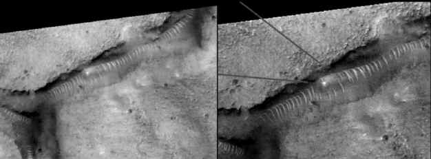
From MGS data (left) and Enterprise enhancement (right).
Other critics have sprung up in the last few days arguing that the "tubes" cannot be artificial because of "their nonuniform appearance: some appear shallow, others deep; the spacing and uniformity of the "arches" differs noticeably--not traits expected of an intelligently designed tunnel system." For starters, we are not saying that it is a tunnel system necessarily, that is just the best of many explanations at the moment. Second, criticisms such as these reveal a significant ignorance of engineering techniques. This non-uniformity of depth could simply be a consequence of the state of "disrepair" they might be in. Some are more filled in than others because more silt or dust has settled into the trenches, or the once coherent tube structure has collapsed. As to spacing and uniformity, the spacing would be different to accommodate differing topography, different characteristics of the surrounding soil, and various other design considerations like potential stresses on the structure. As a for instance, the denser the soil (or the deeper the "tunnel"), the closer the arches would be together to provide more strength. Assuming the arches would all be of uniform spacing and size is like assuming that all the fasteners (about 1 million of them) on a 747 are the same size, type, material, diameter, length and spacing. Let's say 3/16 diameter half inch long aluminum rivets. If aerospace engineers actually had to design with such constraints, we flatly couldn't make airplanes. The same rules apply to architecture. To assume that such a characteristic some how "disqualifies" something as artificial is silly and ignorant.
As you will see below, Enterprise consulting geologist Ron Nicks has prepared a reasoned geological response to some of these criticisms -- specifically, the easily-rebutted claim that these "ribbed patterns" are nothing more than "sand dunes." But we cannot be diverted too far into academic discussions of various abstract geological processes. The argument here is political, not scientific -- as demonstrated by the specific attacks on Clarke and Enterprise. That will continue to be the case. We will not allow ourselves to be pulled off message. The argument now is over which view of Mars that the public will hold -- that of the previous generation (a dead, cold Mars) -- or that of what the data is showing us (a living, breathing Mars). Both sides are now entrenched in their battlements and the war will be determined by great undecided masses in the middle -- who are the obvious target audience of these attacks. To them we have only this to say -- trust not what the establishment tells you -- but what you can know for yourself by examining all the data. We are confident of what you will see ... when your eyes (and minds) are truly open.
Below are the two e-mails from Dr. Bernard Haisch and Dr. David C. Pieri along with Ron Nicks response.
Hal Puthoff asked the following. What do you know about this image?
Nothing--before I looked at it on the web. Then I had the biggest technical laugh that I've had in weeks--without being too snotty. The quote from Arthur Clarke was priceless--boy did he ever get skunked!!
Here's what's going on, to me anyway: First take a look at the synoptic overview image and convince yourself from the lighting of the impact crater that the illumination is coming generally from the left. So what you're looking at is actually a valley, not a "...glass worm..." The bright striations across the feature are actually a series of transverse dunes (I suppose they also qualify as sief dunes) running along the bottom of the valley, more or less perpendicular to its axis. It is interesting that they are so bright, but that could be the effect of both an intrinsically high albedo from a source region different than the valley floor layer, OR just a phase angle effect from a sun facing slope directed more or less toward the camera. Note that a lot of other terrain irregularities from the upper plateau surface also exhibit a bright backscattering effect. This kind of dune train aligned along a valley axis has been seen before (I think even from Viking data) but definitely has been seen before in MGS data. Very interesting, but more from the point of view of people who worry about eolian transport and markings on Mars as indicators of paleo wind regimes...when you have dunes collecting like this, it means that the underlying surface has been fairly swept clean of loose material and that the interdune areas are sand or dust free...with the material piling up in dunes due to interactions between the terrain and the atmospheric boundary layer...the more-or-less constant spacing is an aerodynamic resonance effect (kind of like hydrodynamic standing waves) and is common in terrestrial deserts. Nevertheless, a very interesting and evocative pictures...but not really any more than that. I just love Arthur's comment!!! :-)
Dr. Bernard Haisch
California Institute for Physics & Astrophysics
366 Cambridge Ave. Palo Alto, CA 94306
Director, California Institute for Physics & Astrophysic(CIPA)
Scientific Editor, The Astrophysical Journal
phone: 650-327-6284 ext. 205, fax: 650-327-6294
3-10-01
Subject: More handwaving? Date: 3-9-01 From: Dave Pieri To: rcollins
Dear Robert
This is a professional interpretation based on having labored over literally thousands of Viking Mars Orbiter Images, hundreds of Mars Observer images, many, many, many Landsat, ASTER, and airphotos of the earth, having studied aeolian and fluvial geomorphology at the graduate level at two universities, and well over 20 years of aerial and orbital photointerpretation and optical and radar remote sensing here at JPL/Caltech--and years of field experience in a range of climatic zones from desert to arctic. Also, the subject of my Ph.D. thesis was (the first) systematic global study of martian valley networks, in which I looked at thousands of features, such as the one in the MGS image, over a period of years.
https://mars.jpl.nasa.gov/mgs/
Realize one critical fact--these are not "tubes"...the positive relief is an ILLUSION--the area is crossed by concave valleys. The transverse dune trains are emplaced on the valley floors--this is not new, either or Mars or the Earth. It even occurred at very small scale in the Viking Lander 1 site in Chryse Planitia...not all that far away from where this MGS picture was taken.
Look carefully at how the craters in the larger reference image are lit. Then look at the valley wall shadows. Seeing inverted relief is an easy mistake to make, even by an experienced photointerpreter--at first glance. That's why it's always important to check one's first impression against obvious features in the landscape to get oriented properly.
Also, the picture on the "Enterprise" web site is hopeless.
https://www.enterprisemission.org/images/arthur.jpg
Way overstretched, saturated, and doesn't show other relevant parts of the scene. I downloaded the original data at full resolution from Mike Malin's web site in La Jolla, then used a square-root stretch to even out the contrast. It's clear that these crescentic dune-lets populate the landscape--and occur in all the low troughs or valleys throughout the image (take a look at the subscene attachment). They are a variety of sief and nearly barchan dunes--dead ringer analogs to those in terrestrial deserts. Turn the image 180 degrees (vs. the "Enterprise" picture) so that valleys look like valleys and craters look like craters, not bumps. The 3D striated "glass worm" illusion vanishes, and we're left with a fairly mundane image, exciting only to those of us who have studied the morphology of the valley networks on Mars.
Dunes follow aerodynamic principles--therefore they DO often line up in really precise, repetitive ways related to aero/hydrodynamic streamlines and standing wave resonances.
David C. Pieri, Ph.D. Earth and Space Sciences Division Mail Stop 183-501 Jet Propulsion Laboratory 4800 Oak Grove Drive Pasadena, CA 91109 USA FAX: 818-354-0966 VOICE: 818-354-6299 dave@lithos.jpl.nasa.gov dave@aster2.jpl.nasa.gov
ADDENDUM
By Ron Nicks
Geologist, Terracon
- A GeoTechnical Engineering Company
Enterprise Mission Consulting Geologist
As is common in the milieu of honest scientific inquiry, I find myself in a position of expressing a dept of gratitude to a colleague who obviously disagrees with some, if not all, of my previous interpretations regarding "the worm-like feature" discussed in the body of my earlier article: "Opening a Can of Martian Worms ..."
He graciously has pointed out one very obvious geologic mechanism that he believes to be solely responsible for this evocative image, a mechanism that I freely admit I simply failed to address in my original article. So, out of respect for dissenting opinions, and borne of a genuine desire to understand, I offer the following brief further discussion regarding the emphatic assertion he has made -- that the subject MGS image shows little more than "sand dunes along a valley floor": known also in the trade as "a dune train."
Many of the recent MGS images from Mars do indeed show what appear to be "unusual" areas of windblown deposition. Unusual in the sense that, the various dune patterns represented seem to be generally pervasive on the planet Mars; whereas, one can find similar patterns on Earth, they are generally not quite of the same magnitude or scale. This isn't too difficult to understand, given the extent and violence of known "dust storms" that have been tracked by telescope on Mars for well over a century, culminating with insitu observations by spacecraft overhead and on the surface.
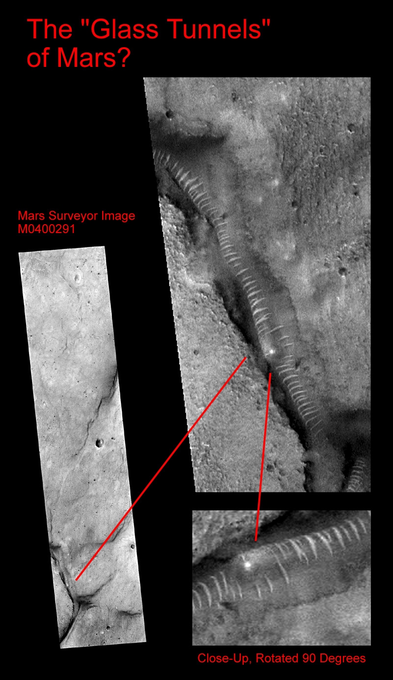
Nevertheless, let's look again at the subject MGS image (MO4-00291), and postulate that the bright "ribs," as I called them, are indeed nothing more than "dunes along the floor of a relatively narrow valley." This is for certain a totally reasonable postulation-after all, in my original article, I even passingly considered a biologic mechanism (which to me, is a lot more bizarre than an assessment of mere "sand dunes").
It is true that, in my previous written analysis, I did not address the potential for the "worm feature" representing a simple Martian dune train; it is also true that prior to committing my thoughts to print, I simply dismissed the idea as obviously geologically untenable. That is exactly the sort of "unscientific" approach that is so frustrating in much of the literature today, and I feel a bit embarrassed that I myself fell prey to the same arrogance.
So, let's look a bit more closely and see if perhaps the feature is not a "Dune" worm after all but rather, a simple Martian dune train.
Consider where this feature is located: near the bottom of (and embedded in the side of) a relatively narrow, precipitous incision (canyon) in the otherwise reasonably level surrounding Martian surface. The canyon also appears to have several "overhangs," locally. Now, ask yourself: "which direction did the wind have to be blowing, to create these dune-like features in this canyon?" Some investigators seem to be focusing on light angles, while totally ignoring the crucial wind direction -- when it's the wind that would create such deposition they are postulating not "the light." (And while it is true that light angles can sometimes give the illusion of "inverted topography", it's also true that it only takes a minimum of field and photo interpretive experience to recognize this possibility and readily adjust for the phenomenon).
The wind either had to be blowing "up" the canyon (toward the north-roughly toward the top of the image here), or "down" the canyon (toward the south). The "dune" forms themselves (if that's what they are) rule out a wind direction at any significant angle to the canyon axis - which is almost due north/south. If the wind was blowing "upstream," then the dunes would be arched in such a manner as their tips -- or the concave part of the "dunes" -- would be pointing, or facing "upstream." That is obviously not the case: in fact, just the opposite is true.
The wind had to be blowing generally "downstream" (from north to south) to create the shapes displayed in MGS image MO4-00291. Indeed, the shapes are quite consistent with all their concave sides pointing downstream. And that's fine.
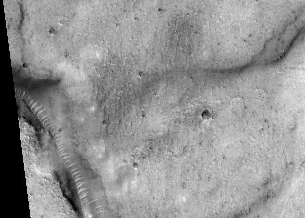
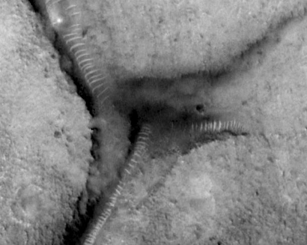
Now, what happens when the wind encounters another entrant into the main canyon -- a '"Y" in the canyon, or the proverbial "fork in the road?" This happens in two places in this canyon system -- one to the north of the bright "highlight" I have ascribed to some kind of object trapped inside the "tube," and one to the south (below).
Well, on encountering such a land surface configuration, one might expect considerable disruption of the previously coherent wind patterns. One might even expect to see considerable disruption in the dune chain itself, with a sudden shift to "chaotic" deposition -- as the eddy currents and wildly varying wind velocities at the intersection result in a truly random (as opposed to previously highly ordered) dumping of the airborne sediment load.
One might even expect that, as the wind blew over the precipice at the mouth of the entrant canyon (the 'Y'), heading south (remember) -- a "plucking effect" would tend to pick up additional sediments and then dump them unceremoniously "in a heap" at the toe of the intruding precipice! There is indeed some evidence of this, but from this image alone it is difficult to precisely determine it's extent -- because the mouth of the entrant canyon (coming in from the upper right - northeast), although partly shadowed, appears to be a very steep slope if not an actual vertical precipice.
However, if what can be seen at the mouth of that entrant is indeed chaotic dumping of sediments, then (because they are significantly dark) they must be of different composition than the "dune-deposited sediments" of high reflectance - which, remember, is being postulated as a more mundane explanation for the mile-plus long repetitive pattern in direct opposition to the structural "tube ribbing model" we have favored.
This seemingly insignificant observation -- a dark deposit at this crucial juncture of the "main" and "entrant" canyon -- flies directly in the face of the "opposition's" model: that the airborne materials making up the "dunes" in the main canyon all derive from some other area -- which visibly contains sorted sediments of significantly higher reflectance than the possible deposits at the base of this overhanging northern cliff.
So in reality, what do we see?
Especially at the southern "fork," we see a striking continuation of the "regular dune pattern" (on the other side of the main valley) southwest, right on past this crucial intersection. Furthermore, you can discern the same pattern spacing (the one extending up this second entrant canyon and ending at the canyon wall) at the toe of the precipice (albeit in shadow) -- with only a slight variation from the regularity of the established "depositional" pattern seen in the main valley. How is that possible?
I've run out of aerodynamic answers at this point.
Not only does the continuing regularity of the striking pattern at the "worm forks" pose a serious, non-trivial problem for the "dune advocates," so does the fact that if our assumption of the wind direction -- "downstream" -- is correct (and that is the only wind direction that makes any sense, given the curving geometry of the subject features themselves -- if they are dunes), then we are also beginning to get into serious trouble with that part of their model as well; because, in the entrant canyons (remember, entering from the upper right), the "ribs" or "dunes" are, in areas, approaching an orientation of nearly ninety degrees to those same features in the main canyon.
So, we now have this same wind, simultaneously blowing at almost right angles to itself - while blithely continuing to deposit the same, highly predictable "dune" pattern in two radically different directions!
I don't think so.
In closing, you might think hard about what you are being asked to accept from JPL and NASA as an "explanation" for this totally fascinating feature -- if you take for granted that these regular, curving "rib-like features" are in fact just simple "Martian sand dunes."
You are being asked to "understand" that what you think you see is an "illusion," and that there is a wind on Mars (as opposed to all our experience on Earth) that picks up a small amount of material (in comparison to the size of the canyon itself) from an area of sediments with visibly higher reflectance than that at the canyon site, and transports that material alone-no mixing with any other stuff -- to the subject canyon, and then proceeds to deposit its unique sediment-load down the entire canyon length, and then down the tributaries (that are high-angle entrants to that canyon) without so much as a significant "hiccup."
If you're willing to believe that, it should not be too great an additional "leap of faith" (for that is what this is) to believe that this same "magic Martian wind" actually has deposited these dunes locally in such a fashion that they appear to be crossing one another, yet each retaining its separate, integral shape (look carefully in the area of the bright "highlight" and "bulge").
Now do you understand why I never seriously considered "sand dunes" as any kind of scientific explanation for this remarkable tube-like feature - with its equally remarkable "supporting rings?"
One mystery still remains: do these investigators, with far more impressive academic credentials, actually believe in their "magic Martian winds?"